National Weather Summary for Monday, August 15, 2016
by David Moran, on Aug 15, 2016 12:07:02 PM
Thunderstorms are possible across the Northern Plains and Upper Midwest as a shortwave trough moves across the region. As an area of low pressure moves toward the Great Lakes, strong to severe thunderstorms will be possible across portions of the Ohio Valley and Mid Atlantic. A cold front moving across the Midwest on Tuesday may allow for a few strong to severe thunderstorms. To the east, an upper level low will move through the Northeast and Ohio Valley, allowing for the potential for thunderstorms. Heavy rainfall will be possible across portions of Arkansas and Texas along a stalled front Tuesday and Wednesday. By Wednesday, thunderstorms will be possible from portions of the Ohio Valley through New England.
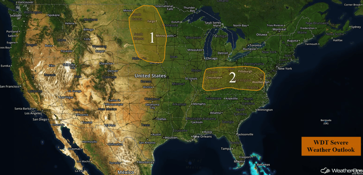
US Hazards
Region 1
As a shortwave trough continues to progress eastward through the High Plains and towards the Upper Midwest today, showers and thunderstorms are expected to develop later this afternoon and into the evening. With moderate instability and weak wind shear across the region, thunderstorms are forecast to begin to increase in coverage and intensity with a few isolated thunderstorms becoming strong to severe later this afternoon. There is a low risk for damaging winds as well as large hail with any thunderstorm that develops.
Major Cities in Region: Bismarck, ND, Fargo, ND, Sioux Falls, SD, Sioux City, IA
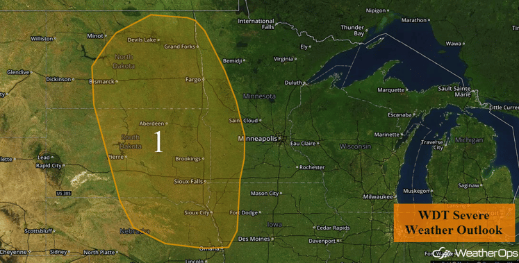
Region 1
Region 2
An area of low pressure near St. Louis is forecast to progress northeastward throughout the day toward the Great Lakes region. The associated warm front currently located across portions of southern Illinois eastward into the Mid Atlantic will also lift northeastward and become centered near portions of southern Michigan, northern Ohio, and central Pennsylvania by late tonight. As this warm front continues to move northeastward, warm moist air will spread across the region. Combined with moderate instability, thunderstorms will increase in coverage and intensity across portions of the Mid Atlantic and Ohio Valley. There will also be some moderate wind shear primarily located near the low in Illinois. As these thunderstorms begin to increase in coverage and intensity this afternoon, a few thunderstorms could be strong to severe with the main threats being damaging winds, however, an isolated tornado or two cannot be ruled out across portions of Illinois and Indiana.
Update 2:46pm EDT: Severe thunderstorms capable of hail and damaging winds are developing across portions of Maryland and West Virginia.
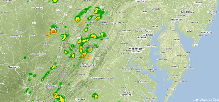
Radar 2:46pm
Major Cities in Region: Cincinnati, OH, Charleston, WV, Washington, DC
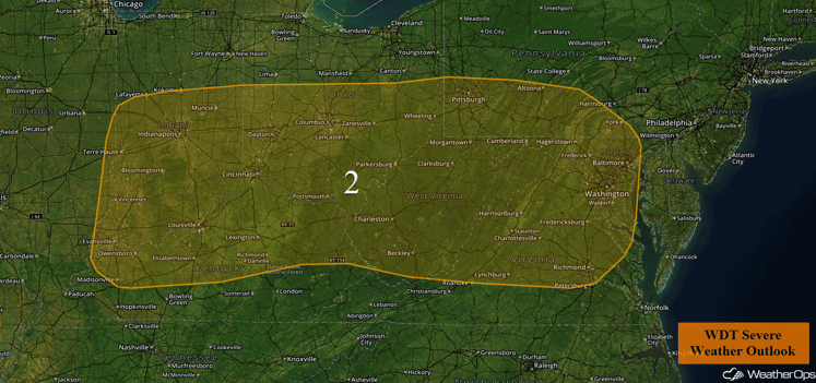
Region 2
Excessive Rainfall Possible from the Midwest through Texas
Scattered showers and thunderstorms are forecast to continue on Monday along a stationary front draped across the Central US. Excessive rainfall amounts of 1-2 inches will be possible from Texas into Ohio with the heavier showers. Additionally, an area of low pressure previously over the Lower Mississippi Valley will lift along the front and into the Missouri Valley. Showers and thunderstorms will be more numerous in the vicinity of the low and the heaviest rainfall totals through early Tuesday morning will coincide with its movement. Currently, the area at risk for more significant rainfall, including the potential for major flooding will exist across the Midwest region, over Illinois, Indiana, and much of Michigan in particular. In this area, local amounts of 3-5 inches may fall with an elevated risk for flooding.
Major Cities in Region: San Antonio, TX, Houston, TX, Shreveport, LA, Little Rock, AR, St. Louis, MO, Chicago, IL, Indianapolis, IN, Cincinnati, OH
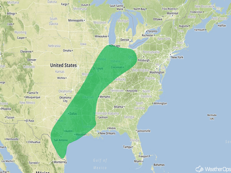
Excessive Rainfall Risk Outline for Monday
Strong to Severe Thunderstorms for Portions of the Midwest on Tuesday
A weak trough of low pressure is expected to bring a cold front into the Midwest on Tuesday. Despite weak shear, an unstable atmosphere may allow for the development of thunderstorms capable of large hail and damaging winds.
Major Cities in Region: Minneapolis, MN, Des Moines, IA, Cedar Rapids, IA
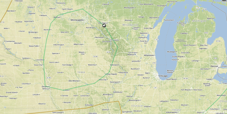
SPC Convective Outlook for Tuesday
Strong to Severe Thunderstorms Possible Tuesday across the Northeast and Ohio River Valley
An upper level low and attendant warm front are forecast to lift across the Northeast region with increasing showers and thunderstorms expected from the Ohio Valley into much of the Northeast. The presence of a stationary front may aid in thunderstorm development with a moderate threat for severe wind and large hail during the afternoon and evening hours. Favorable vertical wind shear may allow for rotation in storms with a lesser risk for a tornado or two. In addition to severe weather across the Northeast, rainfall totals of 1-2 inches and locally higher amounts in excess of 3 inches will be possible, especially across portions of Lower New England.
Major Cities in Region: Paducah, KY, Cincinnati, OH, Pittsburgh, PA, Philadelphia, PA, New York, NY, Boston, MA, Concord, NH
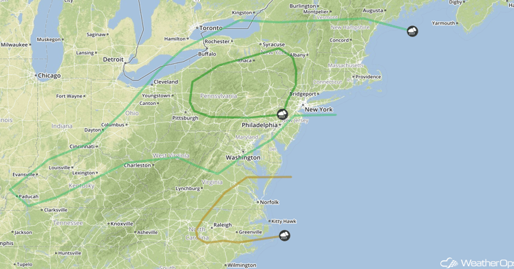
SPC Convective Outlook for Tuesday
Excessive Rainfall Possible Tuesday and Wednesday for Portions of the Southern Plains to Lower Mississippi Valley
A stationary front is forecast to extend across Arkansas and Texas on Tuesday, leading to a threat for excessive rainfall through early Wednesday. Rainfall totals are not expected to exceed an inch; however, even lower rainfall amounts could result in localized flooding impacts due to the dramatic amounts of rainfall received over the past several days. Two day rainfall totals of 2-3 inches with locally higher amounts.
Major Cities in Region: Dallas, TX, Houston, TX, San Antonio, TX, Corpus Christi, TX, Brownsville, TX. Shreveport, LA, New Orleans, LA, Jackson, MS, Memphis, TN
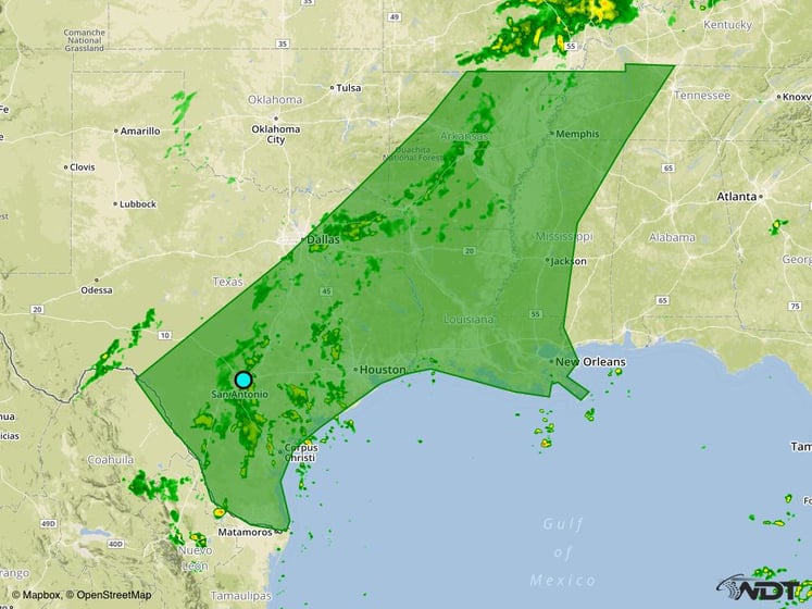
Excessive Rainfall Risk Outline for Tuesday and Wednesday
Strong to Severe Thunderstorms Possible from the Ohio Valley through New England on Wednesday
The area of low pressure that moved through the Northeast on Wednesday, leaving a stationary frontal boundary draped from New England Southward into the Ohio Valley. Isolated showers and thunderstorms will be possible with a low risk for isolated large hail and severe winds.
Major Cities in Region: Charleston, WV, Pittsburgh, PA, New York, NY, Boston, MA
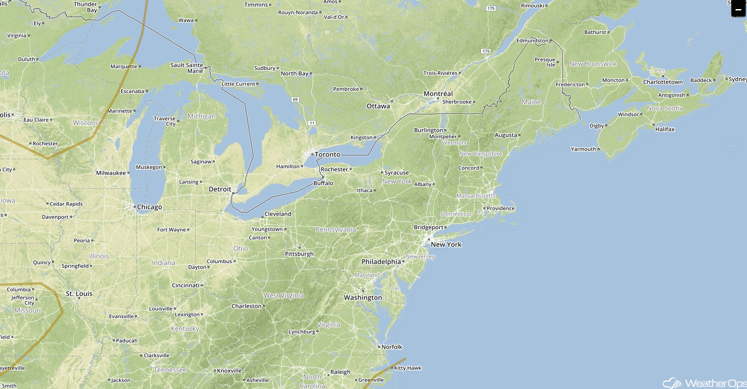
SPC Convective Outlook for Wednesday
This is just a brief look at current weather hazards. We can provide you site-specific forecast information for the purpose of protecting your personnel and assets. Try a 7-day demo right away and learn how timely precision weather information can enhance your bottom line.


