by David Moran, on Sep 21, 2018 11:07:04 AM
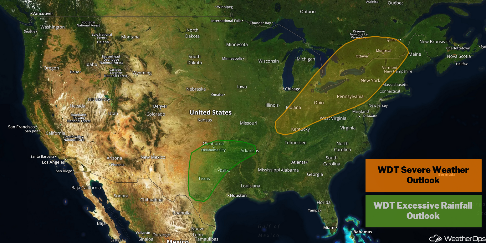
A cold front will be a focus for the development of thunderstorms Friday from the Ohio Valley into the Northeast. Excessive rainfall is likely across the Southern Plains ahead of a slow moving cold front.
- Thunderstorms from the Ohio Valley into the Northeast on Friday
- Excessive Rainfall Friday for the Southern Plains
- Risk for Excessive Rainfall from the Southern Plains to the Central Appalachians Saturday and Sunday
- Tropical Update
US Hazards
Thunderstorms from the Ohio Valley into the Northeast on Friday
As an intensifying area of low pressure lifts northeastward, the associated cold front will track eastward from the Great Lakes toward the East Coast. This front should promote scattered thunderstorm development from the Ohio Valley into the Northeast. Conditions will be favorable for the development of severe thunderstorms. Damaging winds will be the primary hazard, but large hail and a few tornadoes cannot be ruled out.
Major Cities in Region: Indianapolis, IN, Cincinnati, OH, Columbus, OH, Cleveland, OH, Pittsburgh, PA, Buffalo, NY, Albany, NY, Burlington, VT
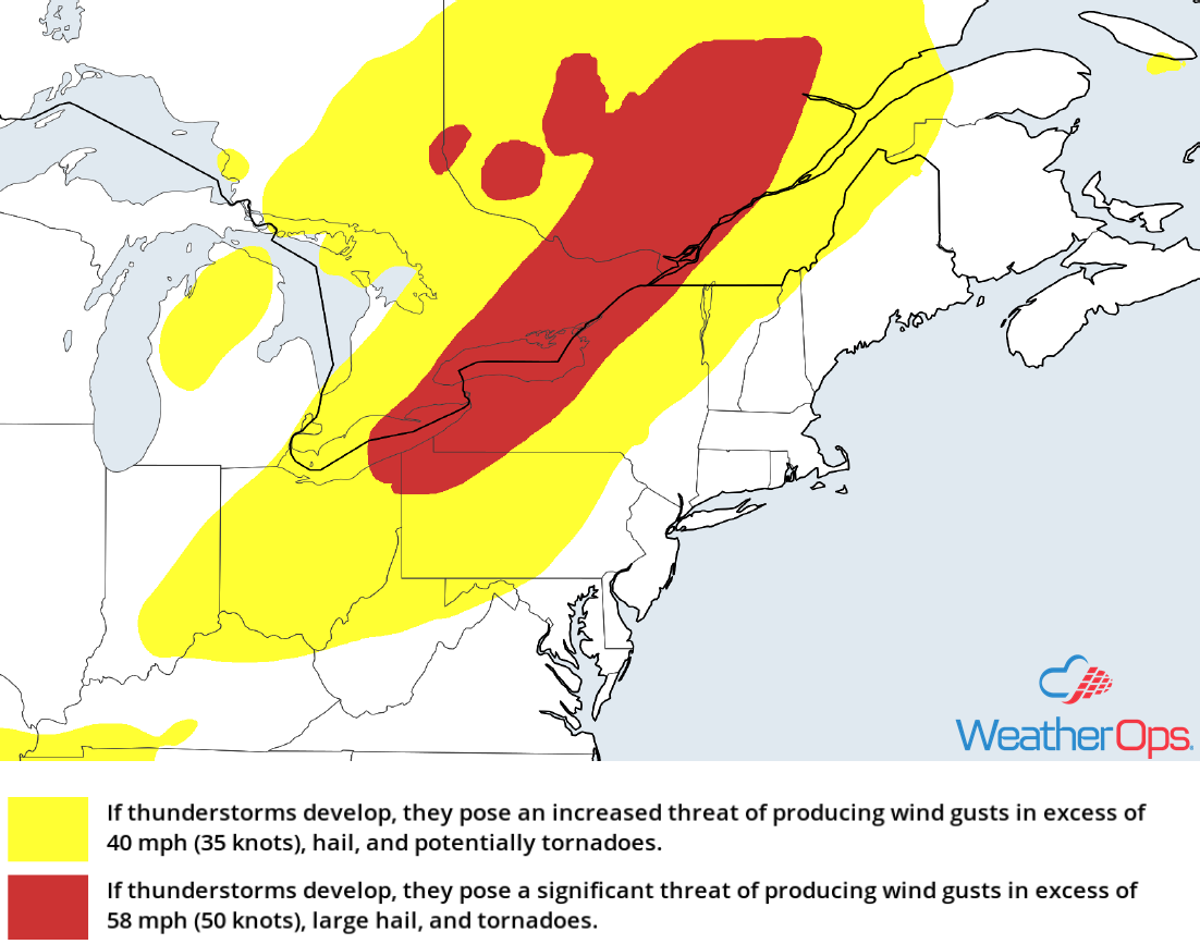
Thunderstorm Risk for Friday
Excessive Rainfall Friday for the Southern Plains
An area of low pressure and associated cold front moving slowly east and southeastward across the Southern Plains are expected to produce widespread showers and thunderstorms on Friday. This activity will bring a risk for excessive rainfall. Rainfall amounts of 2-5 inches with locally higher amounts in excess of 8 inches are forecast, leading to areas of flooding and flash flooding throughout the day.
Major Cities in Region: Wichita Falls, TX, Lawton, OK, Oklahoma City, OK, McAlester, OK, Fort Smith, AR
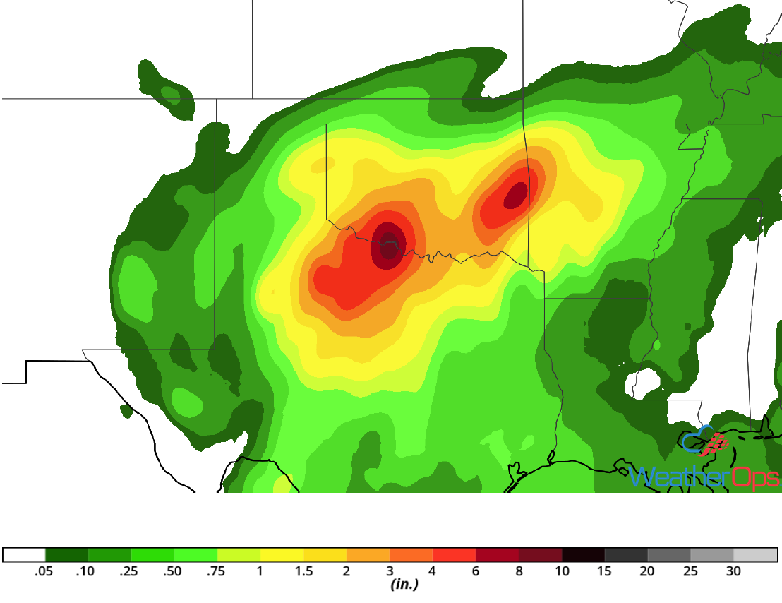
Rainfall Accumulation for Friday
Risk for Excessive Rainfall from the Southern Plains to the Central Appalachians Saturday and Sunday
A front stretching from the Southern Plains eastward into the central Appalachians will stall this weekend. As deep moisture spreads northward, scattered to widespread showers and thunderstorms can be expected both days along the front. This will lead to a risk for excessive rainfall; two day rainfall totals of 1-3 inches with locally higher amounts in excess of 4 inches are expected.
Major Cities in Region: Dallas, TX, Fort Smith, AR, Little Rock, AR, Paducah, KY, Lexington, KY, Charleston, WV
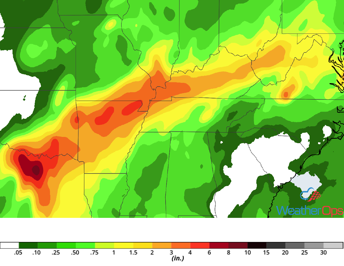
Rainfall Accumulation for Saturday and Sunday
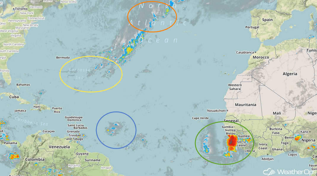
Tropical Update
Showers and thunderstorms associated with a tropical wave located about 600 miles southeast of the Cabo Verde Islands (green oval) are showing some signs of organization. The environment is expected to be conducive for slow development, and a tropical depression could develop early next week while the system moves westward at 15-20 mph.
A weak area of low pressure located about 600 miles east of the Windward Islands (blue oval) is producing disorganized showers and thunderstorms. The combination of dry mid-level air and strong upper level winds is expected to hinder any further development while this system moves west-northwestward at around 10 mph.
Enhanced Infrared Satellite
A broad area of low pressure located just southeast of Bermuda (yellow oval) is producing shower activity while it moves southward at 10-15 mph. Dry air and strong upper level winds is expected to inhibit any significant development over the next few days. However, conditions could become more favorable for development during the middle part of next week.
A non-tropical low is forecast to develop tonight midway between Bermuda and the Azores (orange oval). Conditions are expected to be conducive for the low to acquire subtropical or subtropical characteristics. A subtropical or tropical cyclone is expected to develop late this weekend or early next week while the low meanders over the central Atlantic Ocean.
A Look Ahead
The heavy rain over the central Appalachians this weekend will move into the Mid Atlantic on Monday. Showers and thunderstorms may develop Monday across the Northern Plains and Upper Midwest ahead of a cold front. By Tuesday, showers and thunderstorms will extend from the Great Lakes to the Mid Mississippi Valley. Light showers may develop across the Lower Mississippi Valley and Southeast on Wednesday. Another round of showers and thunderstorms may develop across the Northern Plains and Upper Midwest on Thursday.