National Weather Summary for Friday, October 27, 2017
by David Moran, on Oct 27, 2017 11:04:36 AM
Snow will continue for portions of the Northern Plains Friday as an area of low pressure moves through the region. Elevated winds and seas are expected for portions of the Gulf of Mexico as a cold front moves eastward across the Gulf.
- Snow Continuing Friday across the Northern Plains
- Elevated Conditions for Portions of the Gulf of Mexico through Early Sunday
- Risk for Thunderstorms Saturday across Florida
- Excessive Rainfall for the Northeast on Sunday
- Tropical Update
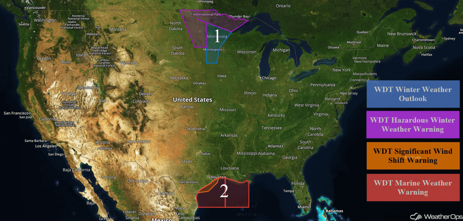 US Hazards
Snow Continuing Friday across the Northern Plains
Snow will continue through the day as an area of low pressure continues to move through the region. Across western portions of Minnesota, snowfall amounts of 1-3 inches with locally higher amounts in excess of 4 inches are expected. In addition, winds 30-40 mph with gusts in excess of 50 mph will allow for blowing snow, low visibilities, and low wind chills. Further east, snow accumulations of 2-4 inches with locally higher amounts in excess of 5 inches are forecast. The heaviest snowfall accumulations will likely be across portions of North Central and Northeast Minnesota where 4-6 inches and locally higher amounts in excess of 8 inches are expected. Winds of 20-30 mph with gusts in excess of 40 mph will lead to blowing snow, visibilities less than 1/4 mile, and low wind chills.
Major Cities in Region: Grand Forks, ND, Fargo, ND, Duluth, MN
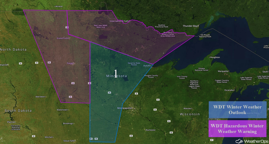 Region 1
Elevated Conditions for Portions of the Gulf of Mexico through Early Sunday
A strong cold front will move through portions of the Gulf of Mexico through early Sunday, bringing strong winds and elevated seas. Behind the front, winds will become northerly at 25-35 knots with gusts in excess of 40 knots. Swells near the shore will be 4-7 feet and 9-13 feet in the deeper waters. In addition, showers and thunderstorms will develop ahead of the front. In eastern portions of the region, winds will be 20-30 knots with gusts in excess of 40 knots. Swells will range 4-7 feet near the shore and 9-12 feet in the deeper waters.
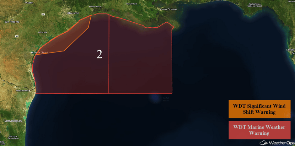 Region 2
Risk for Thunderstorms Saturday across Florida
A tropical low could develop on Saturday. Model guidance is indicating that Invest 93L could strengthen and become a weak tropical storm before it is pushed off to the Northeast on Saturday by an approaching upper level trough. As it passes to the northeast and transitions into a post-tropical low, tropical storm force winds and heavy rainfall are forecast for portions of Florida. Any thunderstorms that develop may become severe with a potential for isolated tornadoes. Rainfall amounts of 3-5 inches with locally heavier amounts in excess of 6 inches are forecast.
Major Cities in Region: Miami, FL, Palm Beach, FL
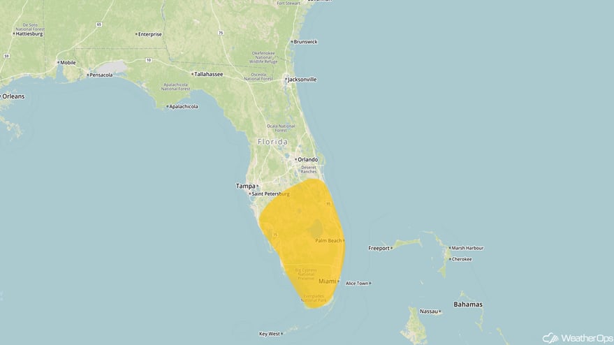 Thunderstorm Risk Outline for Saturday
Excessive Rainfall for the Northeast on Sunday
A complex system will be evolving along the East Coast on Sunday. A strong cold front moving into the Northeast will slow down and showers and thunderstorms will develop ahead of the front. Heavy rainfall is expected with totals ranging 3-4 inches and locally higher amounts in excess of 6 inches.
Major Cities in Region: Washington, DC, Philadelphia, PA, Albany, NY, New York, NY
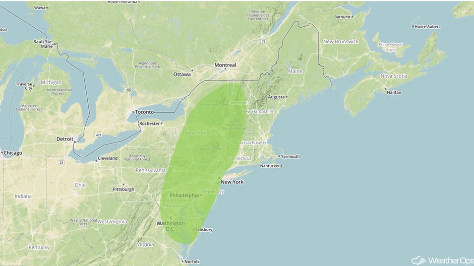 Excessive Rainfall Risk Outline for Sunday
Tropical Update
Shower and thunderstorm activity has increased and become more concentrated in association with a trough of low pressure over the northwestern Caribbean Sea. Environmental conditions are expected to be conducive for development today and Saturday. A tropical depression could develop as the system moves northward over the northwestern Caribbean Sea. Increasing upper level winds will make conditions less favorable for development when the system moves north of Cuba and merges with a cold front on Sunday. This disturbance is expected to produce locally heavy rainfall over the Cayman Islands, Jamaica, and portions of Cuba over the next day or two. These rains are expected to spread northward across portions of South Florida and the Keys on Saturday, and over the northwestern Bahamas Saturday night and Sunday.
 Enhanced Infrared Tropical Satellite
A Look Ahead
An intensifying area of low pressure will move into the Northeast, bringing the potential for widespread heavy rain from eastern New York into Maine on Monday. Rainfall amounts of 3-5 inches with locally higher amounts in excess of 6 inches are forecast. Rainfall should end over the region Monday night as the low moves rapidly into Canada.
This is just a brief look at current weather hazards. We can provide you site-specific weather forecast information for the purpose of protecting your personnel and assets and to assess your weather risk. Try a 7-day demo right away and learn how timely precision weather information can enhance your bottom line.


