National Weather Summary for Friday, October 20, 2017
by David Moran, on Oct 20, 2017 10:20:14 AM
Severe thunderstorms and excessive rainfall are expected from the Upper Mississippi Valley to the Southern Plains on Saturday.
- Severe Thunderstorms and Excessive Rainfall from the Upper Mississippi Valley to the Southern Plains on Saturday
- Excessive Rainfall Potential Saturday for the Pacific Northwest
- Excessive Rainfall for the Lower Mississippi Valley on Sunday
 US Hazards
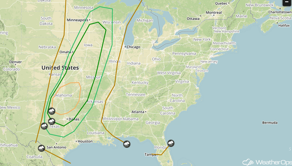
Severe Thunderstorms and Excessive Rainfall from the Upper Mississippi Valley to the Southern Plains on Saturday
As a strong upper-level trough moves eastward across the Rocky Mountains on Saturday, a cold front will progress into central portions of the country. By mid-afternoon, isolated thunderstorms are likely to develop along and just ahead of the front, and some supercell storms will be possible. All severe hazards will be possible with these storms, including large hail, damaging winds, and a few tornadoes. By the evening, thunderstorms are expected to evolve into a well-organized squall line, and the severe threat should transition to a widespread damaging wind threat. The highest severe risk is currently centered over Oklahoma, far northern Texas, and far southern Kansas. In addition to the severe risk, areas of excessive rainfall will likely develop across much of the region. Rainfall amounts of 1-3 inches, with locally higher amounts in excess of 4 inches, are forecast and could lead to flooding issues for some locations.
Major Cities in Region: Oklahoma City, OK, Dallas, TX, Kansas City, MO, Des Moines, IA, Minneapolis, MN
 SPC Convective Outlook for Saturday
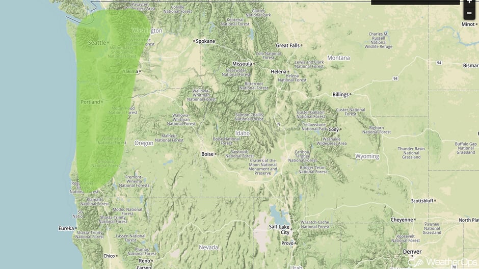
Excessive Rainfall Potential Saturday for the Pacific Northwest
A frontal system moving in from the Pacific Ocean is expected to bring widespread and potentially significant rainfall to much of western Washington and northwestern Oregon on Saturday. The latest indications are that rainfall amounts could average 2-4 inches with locally higher amounts in excess of 6 inches. Runoff and flooding will be potential concerns in some areas.
Major Cities in Region: Portland, OR, Seattle, WA
 Excessive Rainfall Risk Outline for Saturday
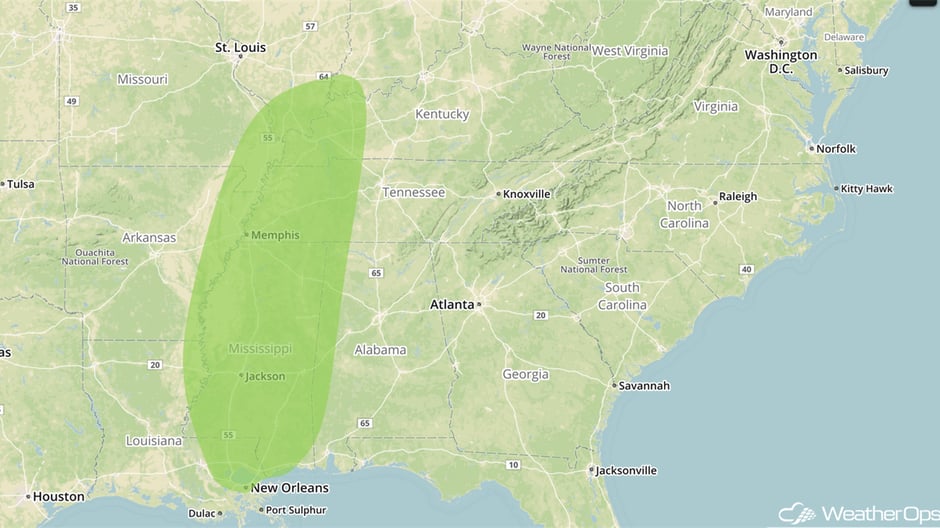
Excessive Rainfall for the Lower Mississippi Valley on Sunday
A cold front moving into the Mississippi Valley region on Sunday will slow its forward progress as a wave of low pressure develops along it over the latter half of the day. This will promote widespread showers and thunderstorms across the
region. While an isolated strong storm cannot be ruled out, it appears that the main risk will be excessive rainfall throughout the region. Rainfall amounts could range from 1-2 inches with locally higher amounts in excess of 3 inches for many locations.
Major Cities in Region: Memphis, TN, Jackson, MS, New Orleans, LA
 Excessive Rainfall Risk Outline for Sunday
A Look Ahead
An area of low pressure and cold front will move across the Ohio Valley and Southeast on Monday, bringing a risk for excessive rainfall to the region. Rainfall amounts of 1-2 inches with locally higher amounts in excess of 3 inches are forecast.
This is just a brief look at current weather hazards. We can provide you site-specific weather forecast information for the purpose of protecting your personnel and assets and to assess your weather risk. Try a 7-day demo right away and learn how timely precision weather information can enhance your bottom line.


