National Weather Summary for Friday, October 13, 2017
by David Moran, on Oct 13, 2017 11:37:03 AM
Thunderstorms may develop across portions of the Central Plains and Midwest on Friday ahead of a cold front. Snow will continue for portions of the Northern Rockies as an area of low pressure moves across the region.
- Thunderstorms for the Midwest on Friday
- Potential for Thunderstorms Friday across the Southern High Plains
- Snow Continuing across the Northern Rockies Friday
- Continued Thunderstorms Saturday for the Central Plains and Midwest
- Tropical Update
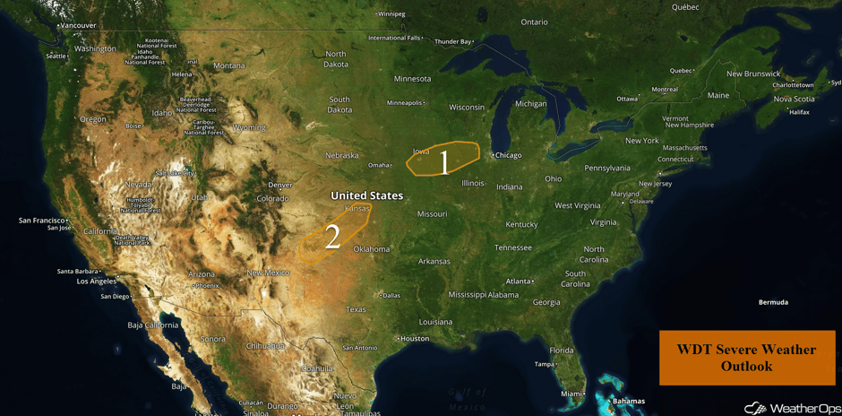 US Hazards
Thunderstorms for the Midwest on Friday
An upper level trough and associated surface low will be approaching the Midwest today and this evening. As this occurs, the associated warm front will begin to lift northward toward Iowa and Illinois, bringing warm moist air into the region. By the evening and overnight hours scattered showers and thunderstorms will begin to develop just to the north of this warm front with a few of these thunderstorms becoming strong to severe. Large hail and damaging winds will be the primary hazards with any of the stronger storms.
Major Cities in Region: Des Moines, IA, Cedar Rapids, IA, Davenport, IA
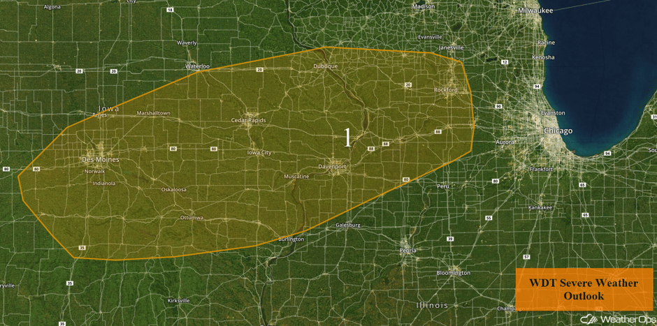 Region 1
Potential for Thunderstorms Friday across the Southern High Plains
As an upper level disturbance makes its way across the region this evening, favorable conditions for some isolated to widely scattered thunderstorms will be in place. A narrow band of deep low level moisture is already in place and is forecast to slowly expand across the Southern Plains this evening. With modest instability and strong shear in place, isolated to widely scattered thunderstorms are forecast to develop late this afternoon across the High Plains of New Mexico . This activity will track northeastward toward Kansas. Given the lack of instability, hail will be the primary hazard with any of the stronger storms that develop.
Major Cities in Region: Amarillo, TX, Dodge City, KS
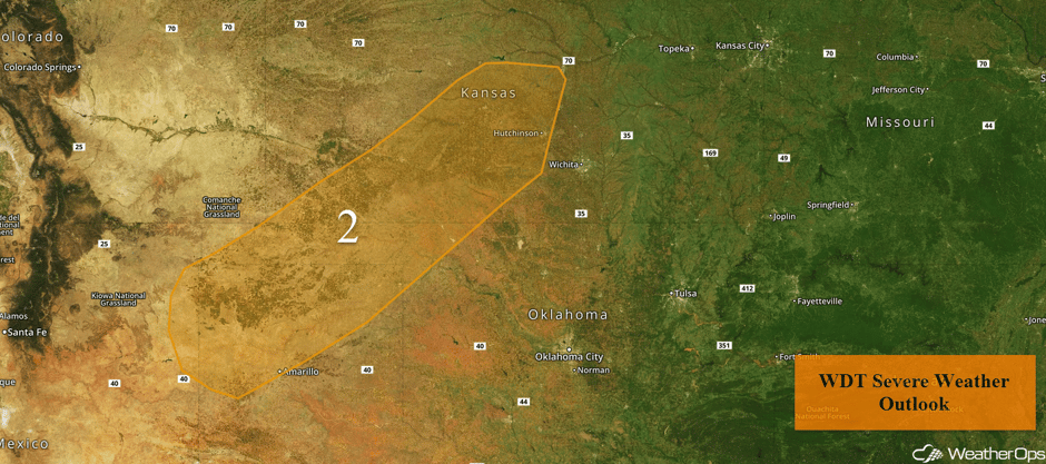 Region 2
Snow Continuing across the Northern Rockies Friday
Snow will continue across the northern Rockies on Friday as a strong but compact area of low pressure moves quickly through the Northern Rockies on Friday, Snowfall accumulations of 6-12 inches are forecast over the higher terrain with less accumulation below 3000 feet. This may make roads slick over the mountain passes. Snow is forecast to taper off by late Friday.
Major Cities in Region: Butte, MT, Helena, MT, Great Falls, MT
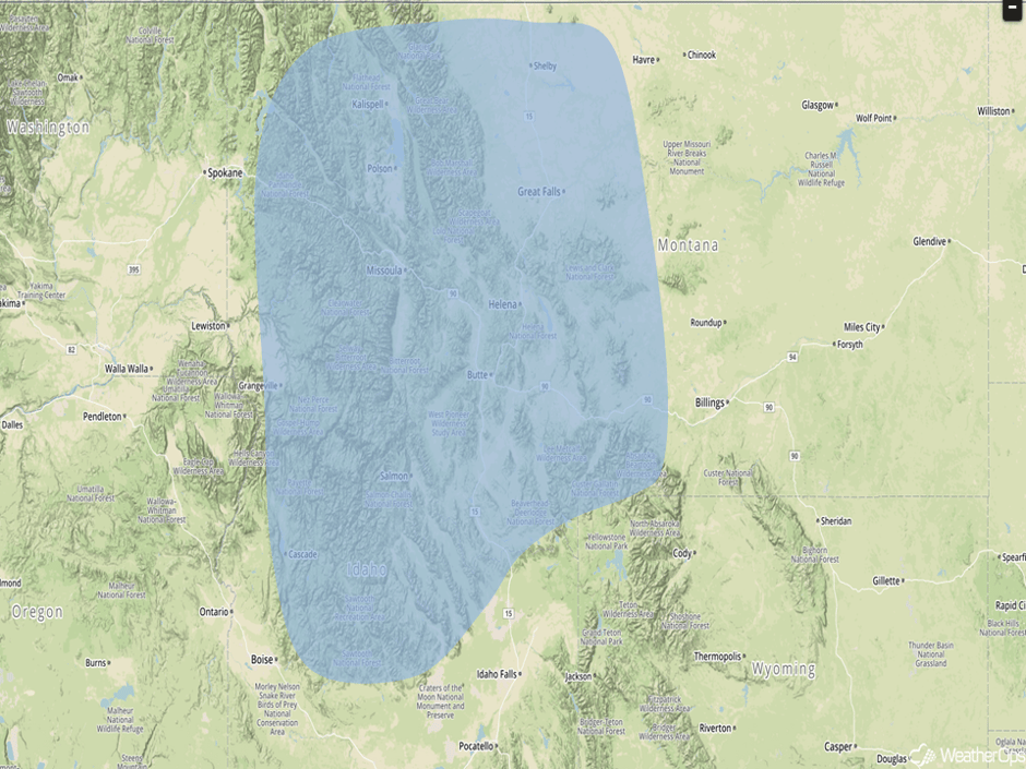 Significant Snowfall Risk Outline
Continued Thunderstorms Saturday for the Central Plains and Midwest
The threat for severe weather is becoming increasingly likely on Saturday across a large area from the southern Great Lakes into the Central Plains. An area of low pressure will continue to develop over the Central Plains and track northeastward into the Midwest. During the morning and into the mid afternoon, showers and thunderstorms will move through the Great Lakes region. By the afternoon hours, the atmosphere will be favorable for the development of severe thunderstorms with large hail and damaging winds the primary hazards initially. Going into the evening hours, a line of thunderstorms will move eastward with damaging winds becoming the primary threat.
Major Cities in Region: Oklahoma City, OK, Wichita, KS, Tulsa, OK, Kansas City, MO, Milwaukee, WI, Chicago, IL
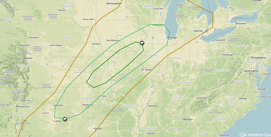 SPC Convective Outlook for Saturday
Tropical Update
Hurricane Ophelia (green oval) is 545 miles southwest of the Azores and is moving east-northeastward at 12 mph. This motion is expected to continue through Saturday with an increase in forward speed. A faster northeastward motion is forecast to begin Saturday night and continue through Sunday. On the forecast track, the center of Ophelia will pass near or southeast of the southeastern Azores late Saturday and Saturday night. Maximum sustained winds are near 100 mph with higher gusts. Little change in strength is forecast during the next 48 hours.
Shower and thunderstorm activity has increased since yesterday in association with a broad area of low pressure about 350 miles east of the northern Leeward Islands (blue oval). Upper level winds are not expected to be conducive for significant development during the next couple of days while the system moves west-northwestward at 15-20 mph and passes north of the Leeward Islands and Virgin Islands.
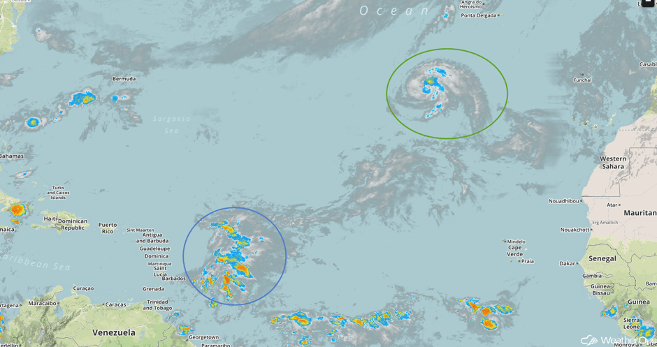 Enhanced Infrared Tropical Satellite
A Look Ahead
Calm conditions are expected for much of the country early next week as high pressure builds across much of the country. Showers and thunderstorms may develop across portions of Florida Monday and Tuesday ahead of a cold front.
This is just a brief look at current weather hazards. We can provide you site-specific weather forecast information for the purpose of protecting your personnel and assets and to assess your weather risk. Try a 7-day demo right away and learn how timely precision weather information can enhance your bottom line.


