by David Moran, on Oct 12, 2018 10:51:28 AM
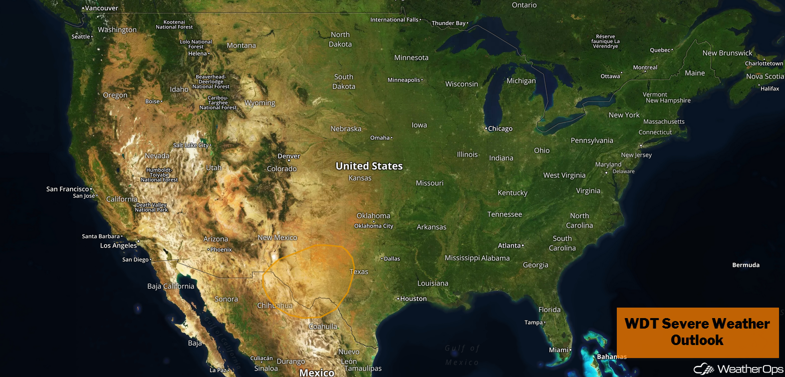
There is a potential for thunderstorms across Southwest and Central Texas through Sunday as the remnants of Sergio move through the region.
- Thunderstorms for Southwest and Central Texas through Sunday
- Excessive Rainfall Saturday for the Southern Plains
- Risk for Excessive Rainfall from the Southern Plains into the Mid Mississippi Valley on Sunday
- Snow Sunday for the Central Plains
- Tropical Update
US Hazards
Thunderstorms for Southwest and Central Texas through Sunday
Strong to severe thunderstorms are forecast across Southwest and Central Texas through Sunday as the remnants of Sergio move across the region. Scattered thunderstorms will be likely each afternoon and evening with strong winds the primary hazard. Isolated hail and tornadoes cannot be ruled out during the afternoon hours.
Major Cities in Region: Odessa, TX, Del Rio, TX, Austin, TX
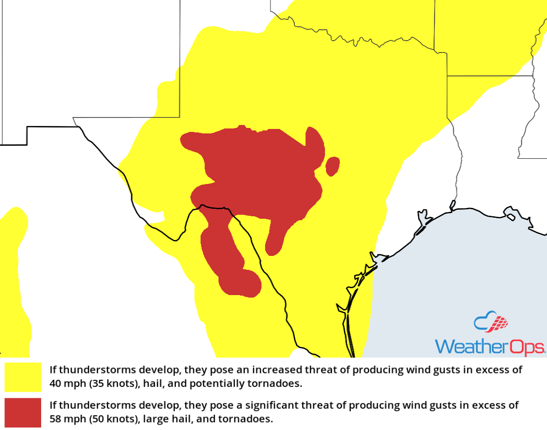
Thunderstorm Risk for Friday
Excessive Rainfall Saturday for the Southern Plains
Heavy rain will return to the Southern Plains on Saturday as a cold front and the remnants of Sergio move through the region. Deep tropical moisture will move from southwest to northeast during much of the day and evening. Widespread rainfall amounts of 1-2 inches with locally higher amounts in excess of 3 inches are expected, leading to a risk for flash flooding.
Major Cities in Region: Wichita Falls, TX, Dallas, TX, McAlester, OK
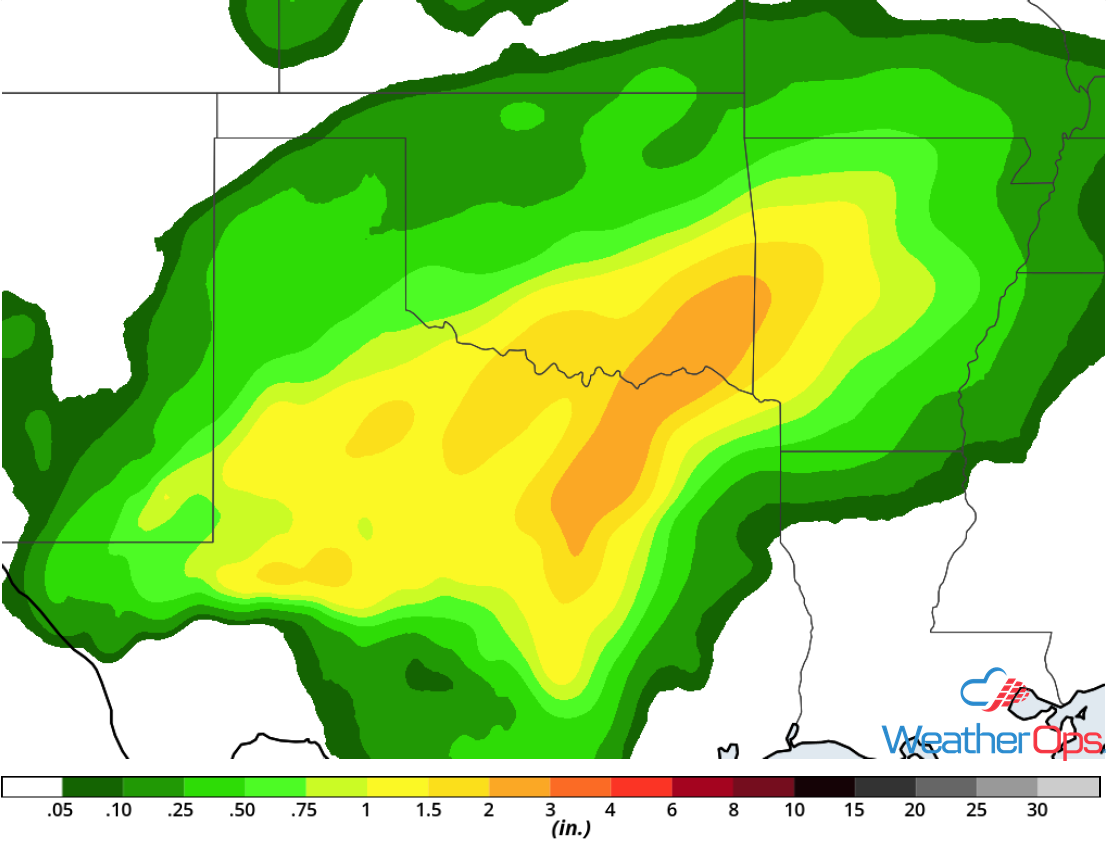
Rainfall Accumulation for Saturday
Risk for Excessive Rainfall from the Southern Plains into the Mid Mississippi Valley on Sunday
Two pockets of heavy rain are forecast over northeast Texas and the Mississippi Valley on Sunday. A cold front will produce widespread showers and thunderstorms along and ahead of the front by the afternoon. Rainfall accumulations of 1-3 inches are forecast, leading to a potential for isolated flash flooding.
Major Cities in Region: Dallas, TX, Little Rock, AR, Paducah, KY
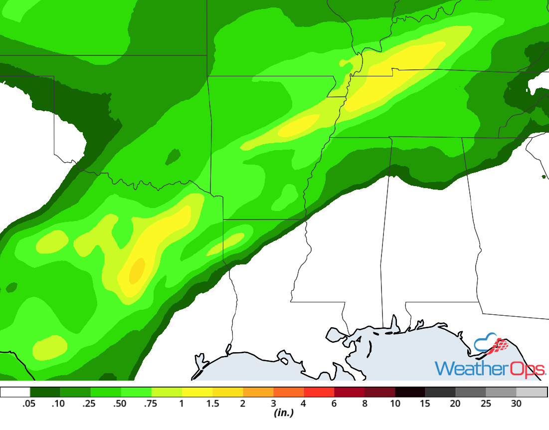
Rainfall Accumulation for Sunday
Snow Sunday for the Central Plains
The first significant snow for the Central Plains is forecast on Sunday as a cold front moves southward across the region. The front will interact with ample Pacific moisture, leading to the development of moderate to heavy snow from eastern Colorado into Kansas and Nebraska. Snow accumulations of 2-4 inches with locally higher amounts in excess of 6 inches will be possible. This will lead to hazardous travel Sunday throughout the day and evening.
Major Cities in Region: Trinidad, CO, Goodland, KS, Lincoln, NE
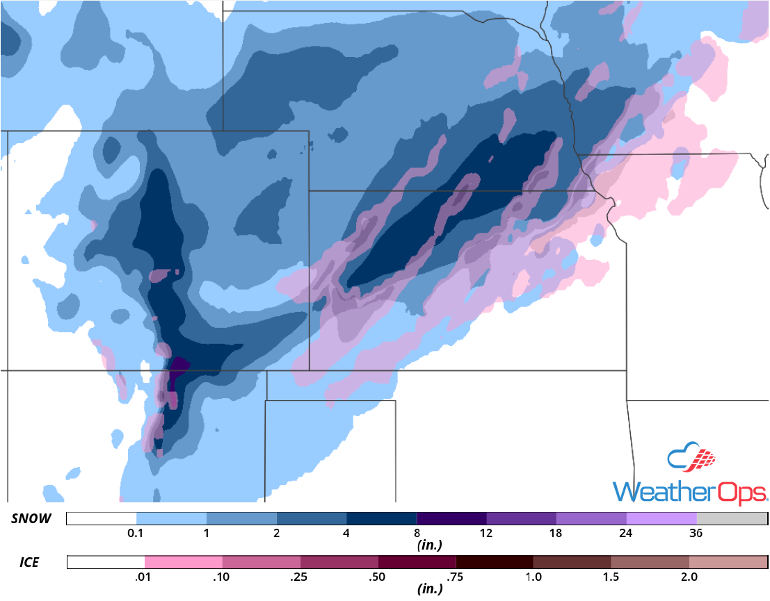
Snow Accumulation for Sunday
Tropical Update
Post Tropical Cyclone Michael (green oval) is 185 miles east-northeast of Norfolk, Virginia and is moving east-northeastward at 29 mph. This general motion is expected to continue for the next couple of days with an increase in forward speed. Maximum sustained winds are at 65 mph with higher gusts. Some additional strengthening is expected today and tonight.
Hurricane Leslie (red oval) is 350 miles south of the Azores and is moving east-northeastward at 32 mph. This motion is expected to continue through Saturday morning followed by a turn toward the east. Maximum sustained winds are at 85 mph with higher gusts. Some weakening is expected over the next day or so. Leslie is expected to transition into a post-tropical cyclone by Saturday night or early Sunday. Additional weakening is expected on Sunday and Leslie is expected to dissipate by Monday.
Tropical Storm Nadine (blue oval) is 790 miles west of the southernmost Cabo Verde Islands and is moving west-northwestward at 9 mph. A west-northwestward to westward motion with an increase in forward speed is expected through the weekend. Weakening is expected over the next few days and dissipation is expected by Sunday.
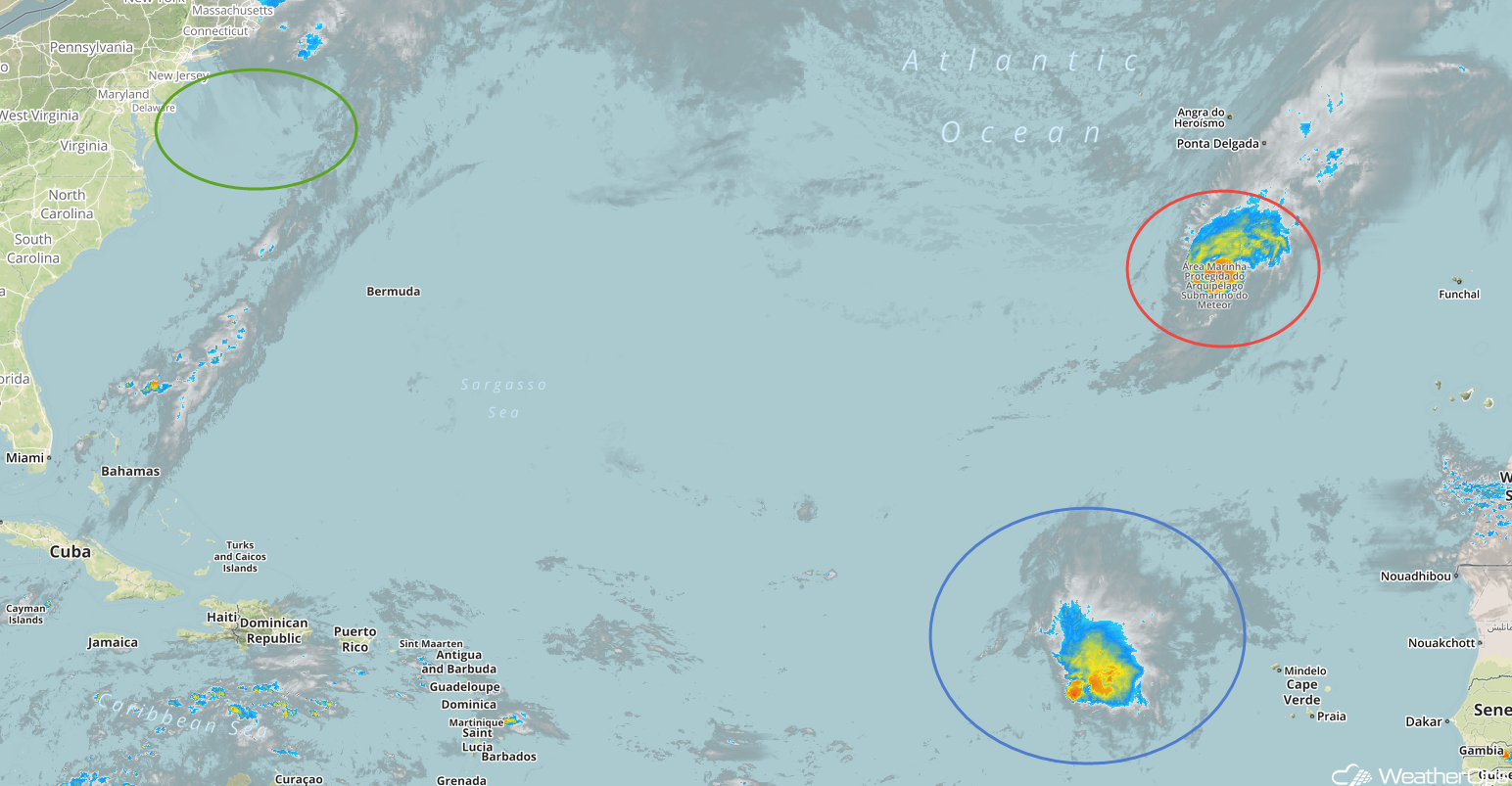
Enhanced Infrared Satellite
A Look Ahead
Heavy rain will extend from southwest Texas into the Ohio Valley on Monday ahead of a cold front. Some light to moderate rain may continue across portions of Texas Tuesday into Wednesday. Light snow is forecast over portions of the Northeast on Thursday as an area of low pressure moves eastward.