


by David Moran, on Nov 30, 2018 11:04:11 AM
Thunderstorms are expected to develop from the Southern Plains through the Lower Mississippi Valley on Friday ahead of a cold front. A strong area of low pressure will produce freezing rain and snow from the Northern Plains into the Great Lakes through Sunday. Snow is forecast across the Rockies through Sunday as an upper level disturbance moves across the region. More snow is forecast across the Sierra Nevadas late Friday into Saturday as an area of low pressure moves into the region. Elevated winds and seas will continue for the Gulf of Mexico through Saturday as an upper level trough moves eastward.
- Thunderstorms from the Southern Plains into the Lower Mississippi Valley Friday
- Freezing Rain and Snow through Sunday from the Northern Plains into the Great Lakes
- Snow for the Rockies through Sunday
- Snow Late Friday into Saturday for the Sierra Nevadas
- Elevated Winds and Seas across the Gulf of Mexico through Saturday
- Potential for Thunderstorms Saturday from the Gulf Coast to the Ohio Valley
- Thunderstorms across the Southeast on Sunday
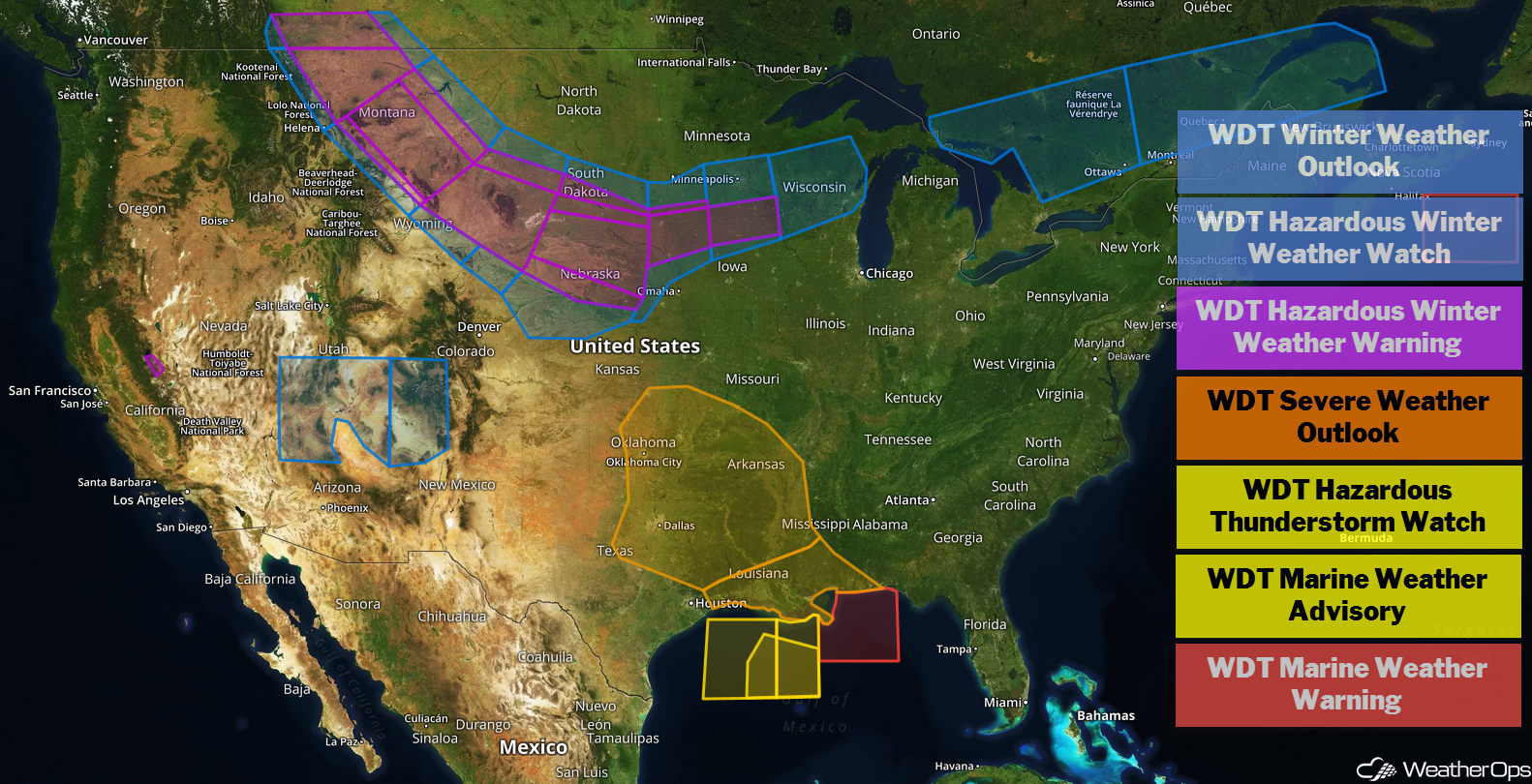
US Hazards
Thunderstorms from the Southern Plains into the Lower Mississippi Valley Friday
As daytime heating and moisture destabilize the atmosphere, a strong area of low pressure will pass just to the north of the region. By the late afternoon and evening, showers and thunderstorms are expected to develop along the cold front across portions of Oklahoma and Texas. This activity will intensify and move eastward. Large hail, damaging winds, and tornadoes will be potential hazards with these storms. As the evening progresses, storms will become linear in nature, reducing the tornado risk and increasing the damaging wind potential.
Major Cities in Region: Oklahoma City, OK, Tulsa, OK, Fort Smith, AR, Shreveport, LA, Little Rock, AR, Memphis, TN, Jackson, MS, New Orleans, LA, Mobile, AL
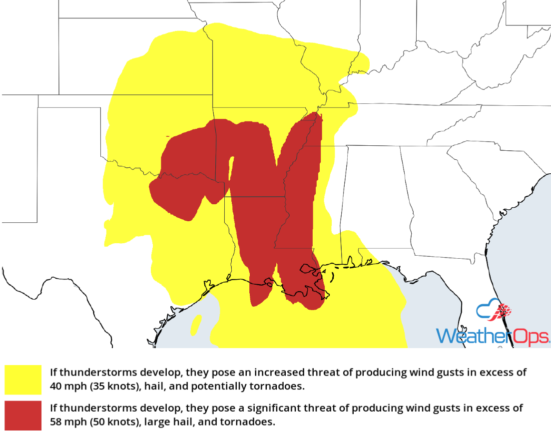
Thunderstorm Risk for Friday
Freezing Rain and Snow through Sunday from the Northern Plains into the Great Lakes
A potent winter storm is expected to move over the region later today and continue into Sunday, bringing freezing rain and snow to the region. Significant snowfall is expected across Nebraska, Iowa, and portions of South Dakota. Widespread snowfall accumulations of 6-10 inches are expected with locally higher amounts in excess of 15 inches. In addition, ice accumulations of more than 0.10 inch are forecast. Wind gusts in excess of 25 mph could result in blowing and drifting snow, reducing visibility. Travel will likely become dangerous, and some roads could become impassable so use extreme caution while driving.
Major Cities in Region: Rapid City, SD, North Platte, NE, Pierre, SD, Grand Island, NE, Sioux Falls, SD, Minneapolis, MN, Green Bay, WI
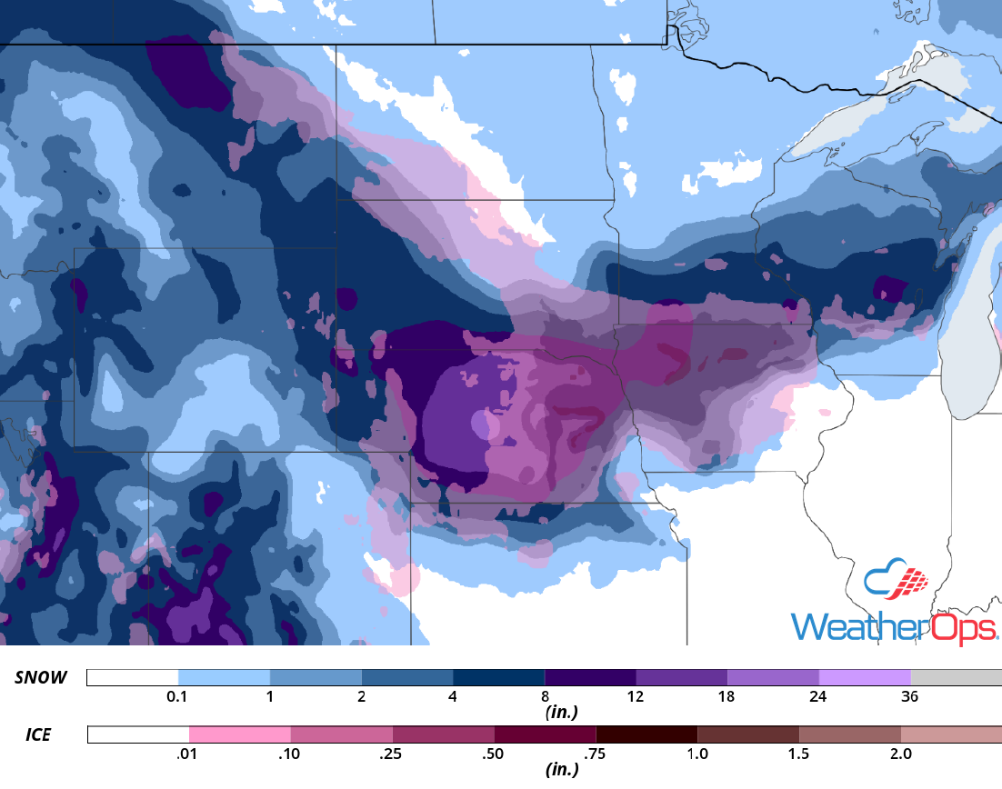
Snowfall and Freezing Rain Accumulation through Sunday
Snow for the Rockies through Sunday
Snow is forecast across the region through Sunday, primarily in the higher elevations. Accumulations will range 4-8 inches with locally higher amounts in excess of 12 inches in the highest elevations. In the lower elevations, 2-5 inches with locally higher amounts in excess of 6 inches are expected. In addition, wind gusts in excess of 35 mph could result in blowing and drifting snow. Significantly reduced visibility and snow covered roadways will make travel hazardous, so use caution while driving.
Major Cities in Region: Salt Lake City, UT, Grand Junction, CO, Durango, CO
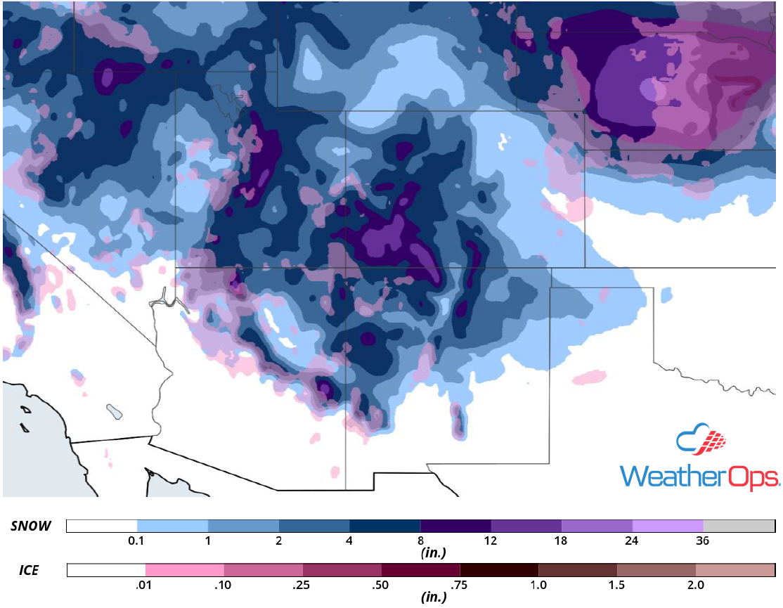
Snowfall Accumulation through Sunday
Snow Late Friday into Saturday for the Sierra Nevadas
A strong area of low pressure is forecast to track into the Sierra Nevadas later this evening bringing another round of heavy snowfall to the region Friday night into Saturday afternoon. Snow will overspread the region from northwest to southeast, becoming heavy at times. Snowfall accumulations will range 4-8 inches with locally higher amounts in excess of 12 inches expected in the lower elevations. In the higher elevations, 8-14 inches with locally higher amounts in excess of 20 inches are forecast. Snow will end from north to south Saturday afternoon.
Major Cities in Region: South Lake Tahoe, CA
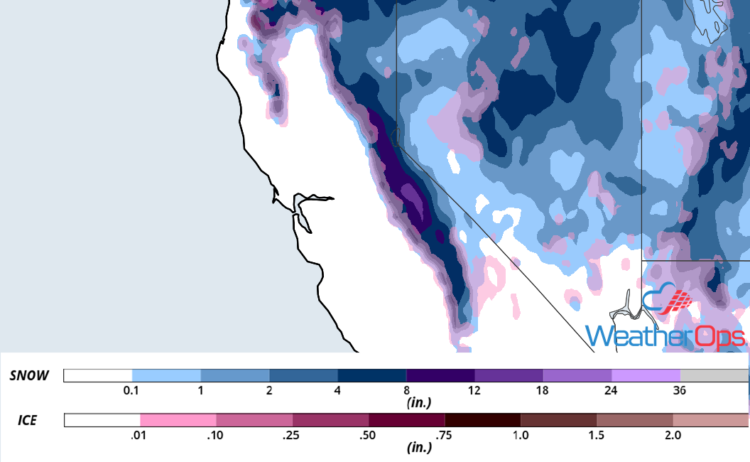
Snowfall Accumulation through Saturday
Elevated Winds and Seas across the Gulf of Mexico through Saturday
An upper level disturbance will track across the Gulf of Mexico, increasing winds and seas through Saturday. Winds will range 22-27 knots with gusts in excess of 30 knots. Seas of 6-9 feet are expected across western areas and 8-11 feet further east. In addition, thunderstorms are expected through Friday evening. Wind gusts in excess of 40 knots, frequent lightning, and waterspouts will be the primary hazards with these storms.
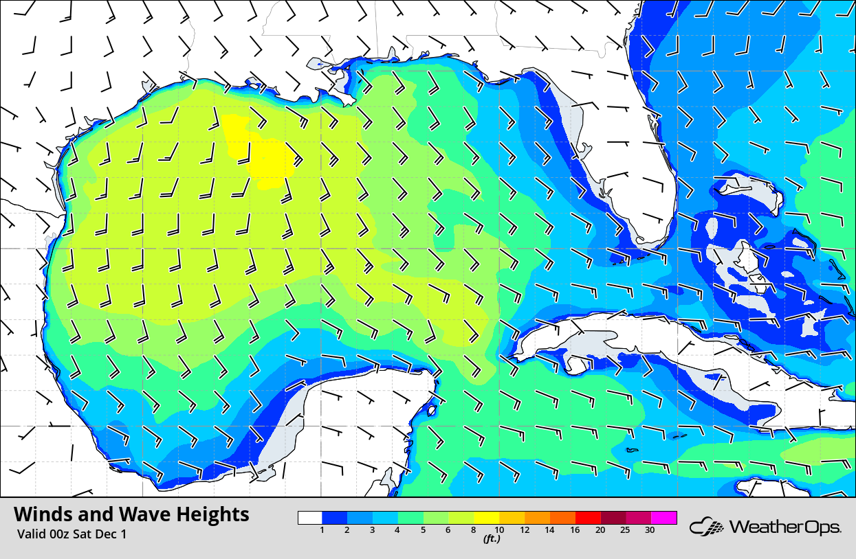
Winds and Wave Heights 6pm CST Friday
Potential for Thunderstorms Saturday from the Gulf Coast to the Ohio Valley
As the area of low pressure expected to produce severe thunderstorms today progresses eastward, shower and thunderstorm activity will likely be ongoing during the early morning. Damaging winds will be the primary hazard with this activity. Storms will likely be clustered, but they are expected to form a line later in the day with damaging winds remaining the primary hazard. An isolated tornado or two and a few instances of large hail cannot be ruled out.
Major Cities in Region: St. Louis, MO, Jackson, MS, New Orleans, LA, Birmingham, AL, Nashville, TN, Tallahassee, FL, Atlanta, GA
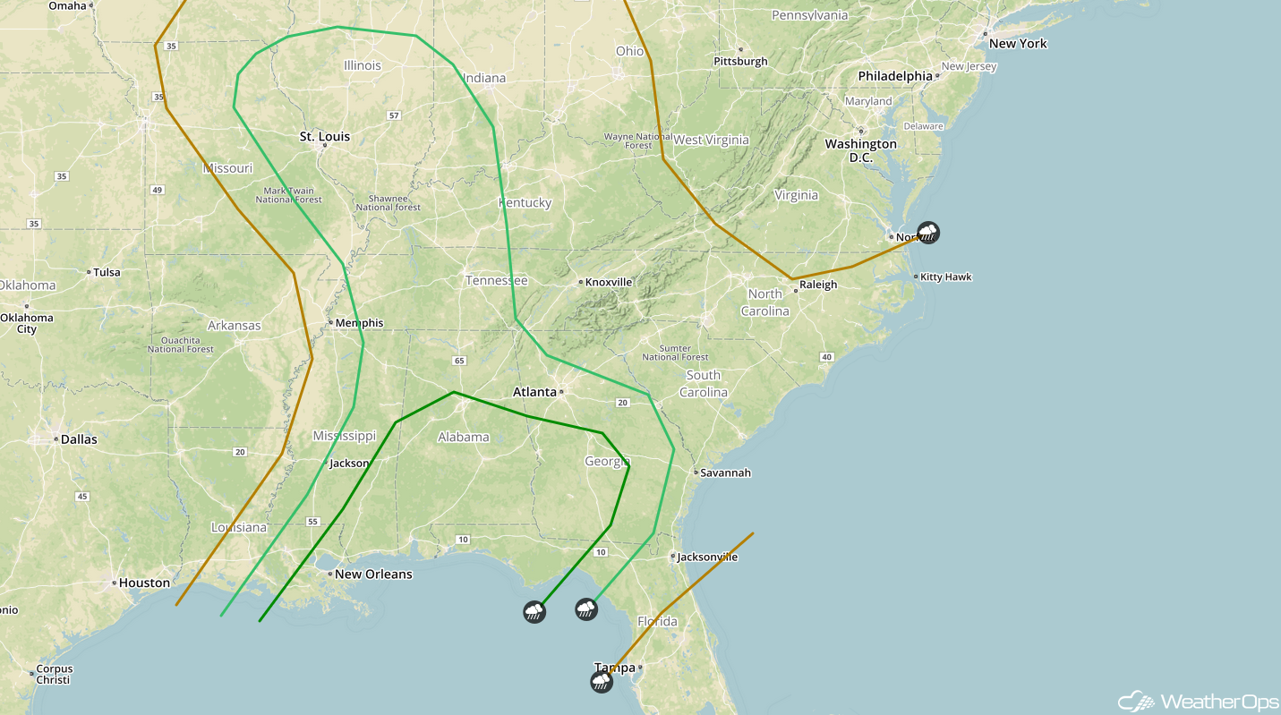
SPC Convective Outlook for Saturday
Thunderstorms across the Southeast on Sunday
The previously described area of low pressure will continue to move northeastward on Sunday, and a few showers and thunderstorms could linger along the front. As instability builds due to daytime heating, this activity could intensify, bringing the potential for gusty winds and isolated large hail. Storms should weaken after sunset after daytime heating is lost.
Major Cities in Region: Tallahassee, FL, Macon, GA, Savannah, GA, Charleston, SC, Raleigh, NC, Myrtle Beach, SC, Wilmington, NC
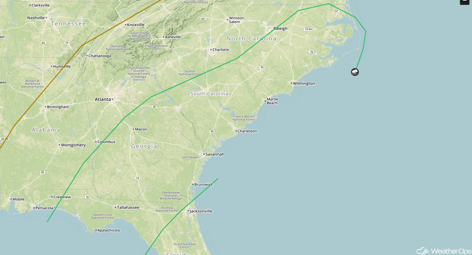
SPC Convective Outlook for Sunday
A Look Ahead
Light snow may develop across portions of the Southern Plains on Monday as an area of low pressure moves eastward. Snow will extend from the Mid-Mississippi Valley on Tuesday. By Wednesday, heavy snow may develop over portions of the Appalachians. Another round of snow may develop Thursday across the Sierra Nevadas.
