


by David Moran, on May 25, 2018 11:23:08 AM
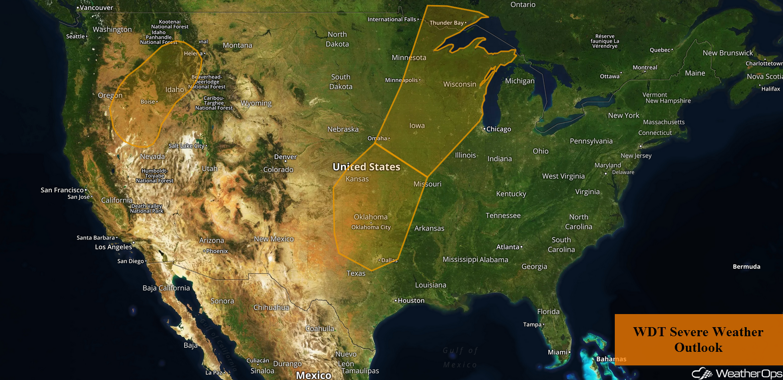
Sub-Tropical Storm Alberto has developed near the Yucatan Peninsula and will move northward through the weekend. Thunderstorms are forecast for portions of the Interior Northwest on Friday as an upper level trough moves across the region. An area of low pressure near the US/Canada border will allow for thunderstorm development across the Upper Mississippi Valley. As an upper level trough moves over the Plains, thunderstorms will develop across portions of the Central and Southern Plains. A weak area of low pressure may allow for the development of thunderstorms across Northern Maine.
- Thunderstorms for the Interior Northwest on Friday
- Potential for Thunderstorms Friday across the Upper Mississippi Valley
- Risk for Thunderstorms across the Central and Southern Plains on Friday
- Thunderstorms Friday across Northern Maine
- Excessive Rainfall for the Southeast Friday
- Risk for Excessive Rainfall Friday across South Florida
- Thunderstorm Potential for the Northern Rockies on Saturday
- Risk for Thunderstorms Saturday across Southern Florida
- Excessive Rainfall for Saturday and Sunday from the Gulf Coast into the Carolinas
- Thunderstorms for the Northern Central High Plains on Sunday
- Tropical Update
 US Hazards

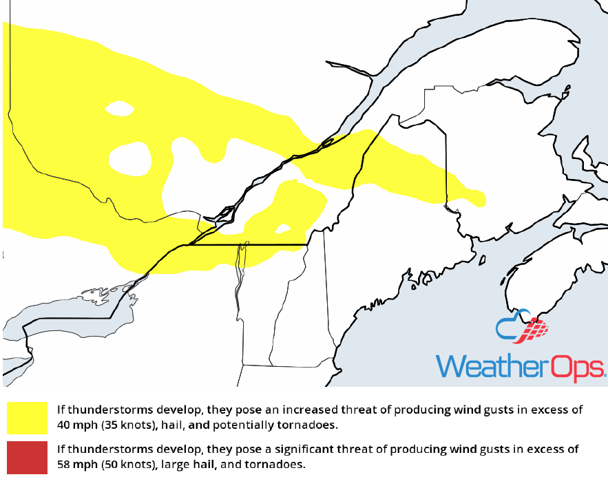
Thunderstorms for the Interior Northwest on Friday
An upper level trough will track eastward into the western CONUS today. Daytime heating across portions of the Interior Northwest will increase instability across much of the region. With this upper level trough enhancing lift across the region, showers and thunderstorms are forecast across portions of the Pacific Northwest this afternoon with a few of these storms possibly becoming strong to severe in nature. Damaging wind gusts and hail are forecast to be the primary hazard within any of the stronger storms across the region with thunderstorm activity slowly diminishing as the evening progresses.
Major Cities in Region: Boise, ID, Missoula, MT, Butte, MT
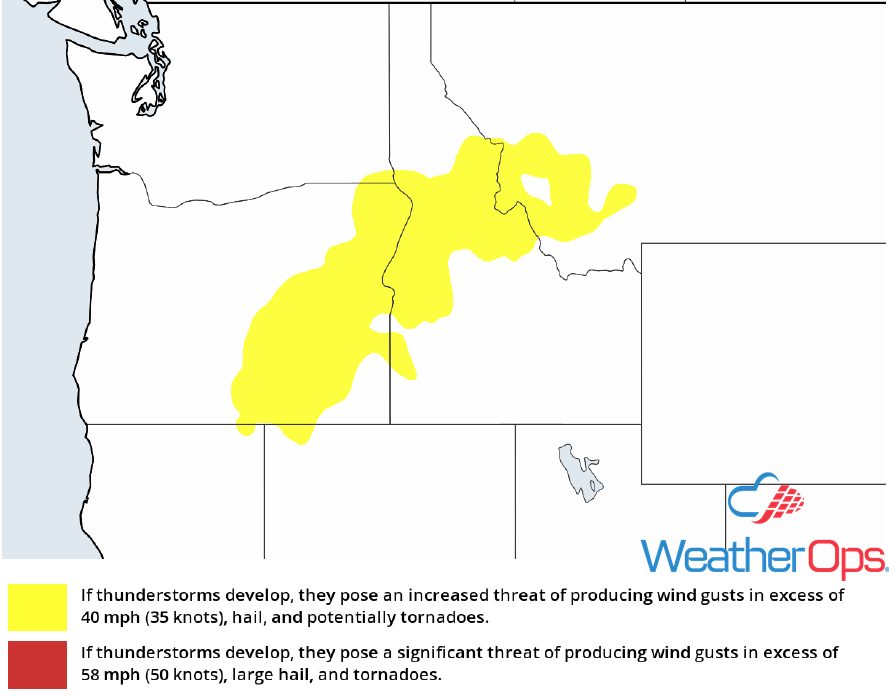 Thunderstorm Risk for Friday
Potential for Thunderstorms Friday across the Upper Mississippi Valley
An area of low pressure near the US/Canadian border will slowly track eastwards with a stalled frontal boundary extending southwestwards into the Central Plains. Early morning thunderstorm activity across the Upper Mississippi River Valley and southern Ontario will give way to clearing conditions across the region this afternoon. This daytime heating will help to increase instability during the afternoon hours and with southerly flow continuing to bring warm moist air northward out ahead of this stalled front, additional thunderstorm development is forecast this afternoon and evening. Although there is only modest wind shear spread across the region today thunderstorms are still forecast to form linear segments with a few of these segments becoming strong to severe in nature with damaging wind gusts and hail being the primary concern with these stronger storms. Storms are forecast to weaken as the sun sets and daytime heating is lost.
Major Cities in Region: Des Moines, IA, Waterloo, IA, Rochester, MN, Wausau, WI
 Thunderstorm Risk for Friday
Risk for Thunderstorms across the Central and Southern Plains on Friday
Early morning thunderstorm activity is forecast to leave some leftover outflow boundaries across portions of the Central and Southern Plains today. With daytime heating creating ample instability across the region, as well as increasing wind shear this evening conditions are forecast to be favorable for shower and thunderstorm development this afternoon and evening as an upper level disturbance tracks across the area. Model guidance suggests thunderstorms will form small linear segments to begin the afternoon and continue to increase in intensity with a few of these storms becoming strong to severe in nature into the early evening hours. Thunderstorms are then forecast to possibly merge later this evening into a line as the wind shear increases near sunset. The primary hazard with any of these stronger storms will be damaging wind gusts and small hail.
Major Cities in Region: Lawton, OK, Oklahoma City, OK, Tulsa, OK, Joplin, MO
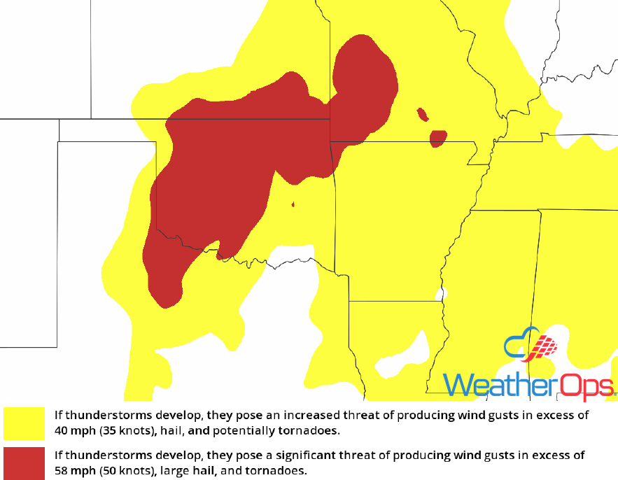 Thunderstorm Risk for Friday
Thunderstorms Friday across Northern Maine
A weak surface low and its associated cold front are forecast to track eastwards across portions of southeastern Quebec and northern Maine today. With strong wind shear spread across the region and instability building this afternoon, scattered showers and thunderstorms are forecast out ahead and along this approaching cold front. Given the favorable conditions, some of these thunderstorms could become strong to severe in nature with damaging wind gusts being the primary hazard. Model guidance suggests thunderstorms activity should quickly diminish after the sunsets as daytime heating is lost.
Major Cities in Region: Caribou, ME
 Thunderstorm Risk for Friday
Excessive Rainfall for the Southeast Friday
The same upper level disturbance that brought heavy to excessive rainfall to the region yesterday will once again bring that same threat to the Southeast today. This upper level disturbance will continue to move little throughout the day and with abundant moisture spread across the region today as well as building instability during the afternoon and evening hours, widespread slow moving showers and thunderstorms are forecast across the region this afternoon and evening. Given the slow moving nature of these showers and thunderstorms heavy to excessive rainfall will once again be possible across the region especially in areas where thunderstorms train over each other. This will lead to a threat for flash flooding and excessive runoff across the region. The shower and thunderstorm threat will quickly diminish once the sunsets and daytime heating is lost.
Major Cities in Region: Montgomery, AL, Columbus, GA, Macon, GA
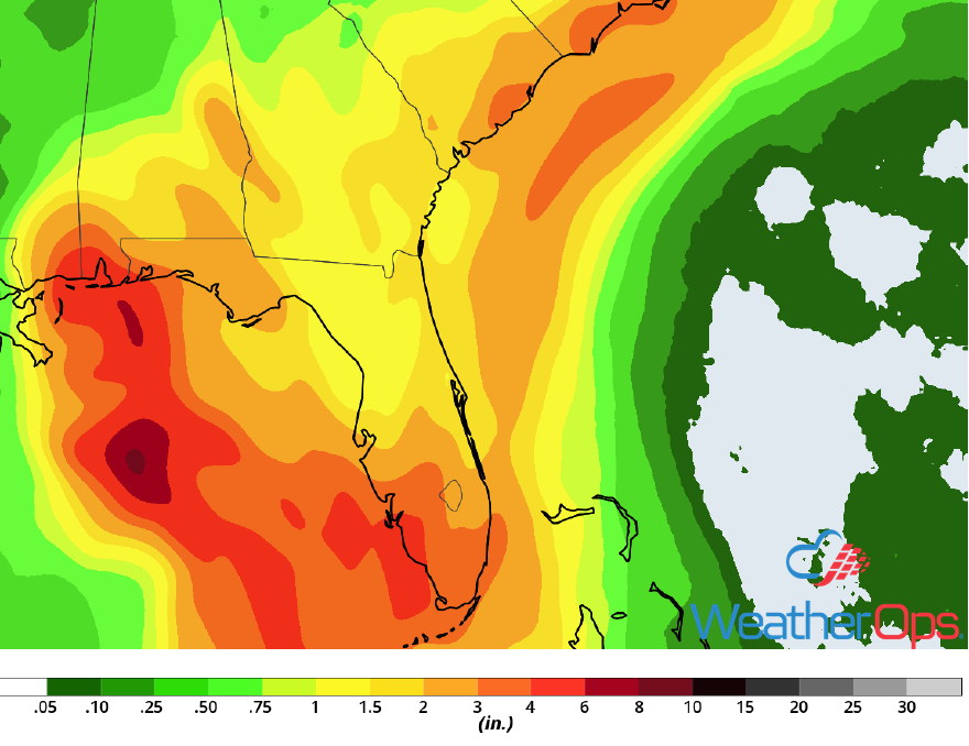
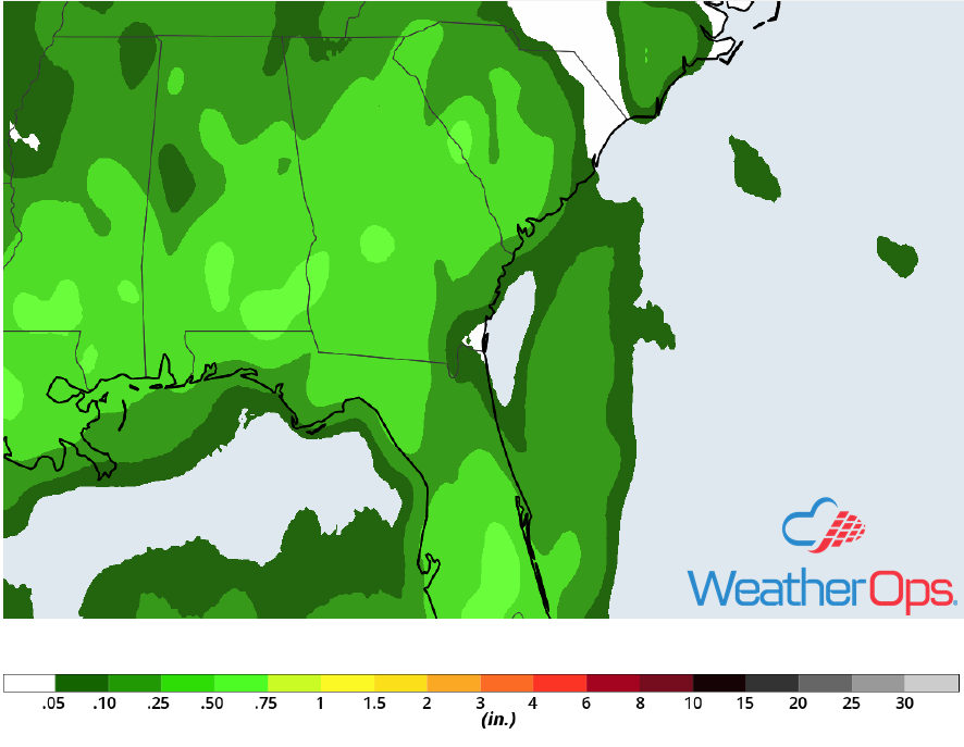 Rainfall Accumulation for Friday
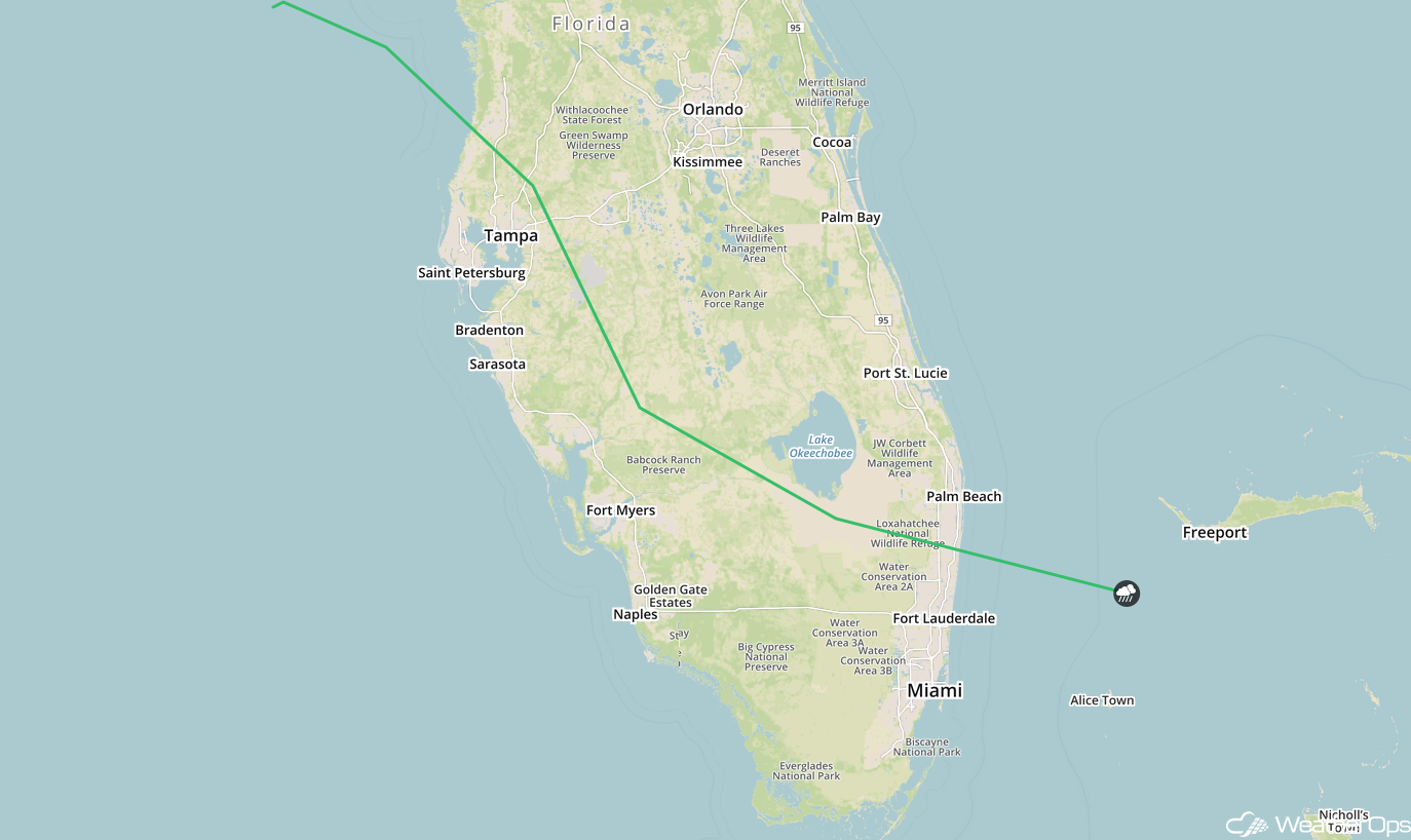
Risk for Excessive Rainfall Friday across South Florida
A shortwave tough will track southeastward into the region today strengthening the broad trough that is already over Florida. With Sub-Tropical Storm Alberto to the south near the Yucatan Peninsula continuing to pump tropical moisture northwards, anomalously high moisture content will build into the region today. This broad trough will provide enough focus for multiple rounds of rain and thunderstorms today. With the high amounts of low level moisture across the region any shower or thunderstorm that does form across the area will have a threat to bring heavy to excessive rainfall to the region today. Model guidance suggests widespread rainfall amounts of 1-2 inches will be possible today across South Florida with localized amounts in excess of 4 inches possible. This will lead to a threat for flash flooding across the region.
Major Cities in Region: Fort Myers, FL, Naples, FL
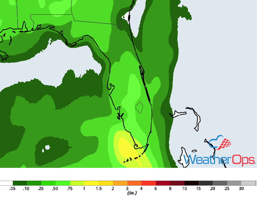 Rainfall Accumulation for Friday
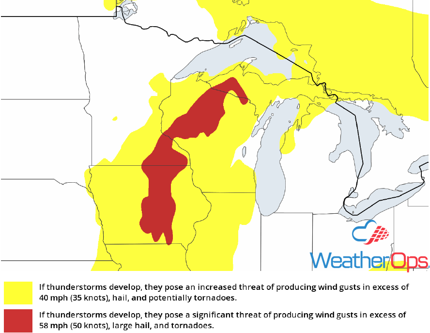
Thunderstorm Potential for the Northern Rockies on Saturday
An upper level trough will continue to slowly track eastward across the Intermountain West. At the surface, a low pressure system will track east-southeastward across the Great Basin. Daytime heating will support widespread instability across the region and with the surface low providing ample lift, scattered shower and thunderstorm development is forecast. As we get later into the afternoon hours a few of these storms could reach strong to severe levels with damaging wind gusts, and small hail being the primary concern. These thunderstorms will track eastward Saturday afternoon across the region with thunderstorms coverage diminishing after sunset as instability decreases with the loss of daytime heating.
Major Cities in Region: Butte, MT, Helena, MT, Great Falls, MT, Billings, MT, Glasgow, MT, Glendive, MT
 SPC Convective Outlook for Saturday
Risk for Thunderstorms Saturday across Southern Florida
Sub-Tropical Storm Alberto is forecast to be making its way northwards on Saturday. Although the exact track of this system is currently still unknown, the system is forecast to strengthen as it tracks northwards across the eastern Gulf. As this system does this, ample tropical moisture will be pulled northwards into Southern Florida. With a favorable conditions consisting of ample lift from the nearby system and instability spread across the region, thunderstorms are forecast to make their way northwards across southern Florida as well. A few of these thunderstorms could become strong to severe in nature with damaging winds and small hail being the primary concern, however a few brief tornadoes could also be possible especially near the coastlines as thunderstorms track onshore.
Major Cities in Region: Tampa, FL, Fort Myers, FL, Naples, FL, Miami, FL
 SPC Convective Outlook for Saturday
Excessive Rainfall for Saturday and Sunday from the Gulf Coast into the Carolinas
Sub-Tropical Storm Alberto will begin to track northwards across the eastern Gulf of Mexico while strengthening on Saturday and Sunday. The direct impacts from this system are still uncertain due to model variability. Regardless, Alberto will bring a large swath of tropical moisture northwards across the Southeast tomorrow and on Sunday. Rain and thunderstorm activity is forecast to start in South Florida on Saturday and continue to spread northwards into the Carolinas on Sunday. With ample moisture available and Alberto providing ample lift, heavy rainfall will persist all weekend. Model guidance currently suggests widespread rainfall amounts of 2-4 inches locally 6+ will be possible on Saturday and Sunday, with additional rainfall also possible on Monday and Tuesday as this system continues northwards. This will lead to a widespread threat for flooding across the region. Rainfall is forecast to end from south to north across the region beginning early next week.
Major Cities in Region: Mobile, AL, Columbus, GA, Macon, GA, Charleston, SC
 Rainfall Accumulation for Saturday and Sunday
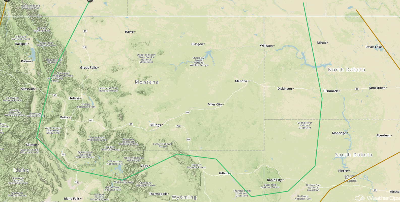
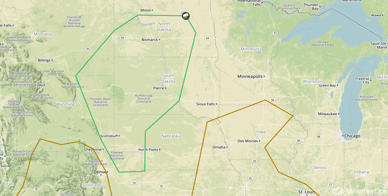
Thunderstorms for the Northern Central High Plains on Sunday
An upper level disturbance will continue to slowly make its way eastwards across the Intermountain West on Sunday. As this occurs daytime heating will lead to ample instability spreading across the High Plains and with ample moisture already in place and this upper level disturbance providing ample lift, scattered shower and thunderstorm development is forecast across the region during the afternoon and evening hours. Some of these storms could become strong to severe in nature with damaging wind gusts and hail being the primary hazard within any of the stronger storms. Thunderstorm coverage and intensity are forecast to quickly diminish as the sunsets and daytime hating is lost.
Major Cities in Region: Scottsbluff, NE, Pierre, SD, Bismarck, ND
 SPC Convective Outlook for Sunday
Tropical Update
Sub-tropical Storm Alberto has developed over the northwestern Caribbean and is moving north-northeastward at 6 mph. Alberto is expected to move northward through the weekend with a turn to the northwest by Monday. Alberto is forecast to pass near the east coast of the Yucatan Peninsula tonight and be near the western tip of Cuba Saturday morning. By Saturday night, Alberto should move into the southeastern Gulf of Mexico by Saturday night, and approach the north-central Gulf Coast on Monday. Sustained winds are near 40 mph with higher gusts. Some strengthening is expected over the next 72 hours. Rainfall amounts will range 8-12 inches with locally higher amounts in excess of a foot from southeast Louisiana to the Florida Panhandle.
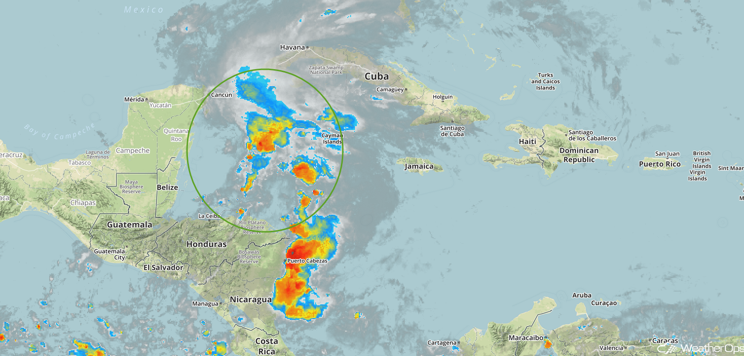 Enhanced Infrared Satellite
A Look Ahead
Alberto will continue to bring heavy rain to portions of the Southeast through at least Tuesday, bringing the potential for flooding to much of the region. Elsewhere, thunderstorms may develop across portions of the Plains early next week as an area of low pressure moves across the region.
This is just a brief look at current weather hazards. We can provide you site-specific weather forecast information for the purpose of protecting your personnel and assets and to assess your weather risk. Try a 7-day demo right away and learn how timely precision weather information can enhance your bottom line.
