National Weather Summary for Friday, May 12, 2017
by David Moran, on May 12, 2017 11:02:08 AM
A cold front moving through the Southeast will allow for a risk of thunderstorms on Friday. Thunderstorms may develop across Montana Friday as an upper level trough moves eastward. Heavy rainfall is expected across the Mid Atlantic on Friday along a stalled front.
- Thunderstorms across the Southeast on Friday
- Thunderstorm Potential Friday across Montana
- Excessive Rainfall for the Mid Atlantic Friday
- Risk for Excessive Rain across the Northeast on Saturday
- Strong to Severe Thunderstorms Possible Saturday for Florida and Georgia
- Excessive Rainfall Potential Sunday across New England
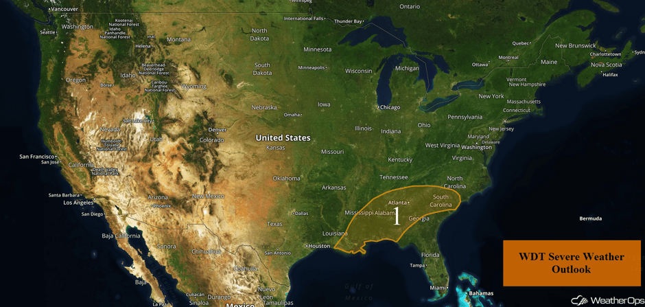 US Hazards
Thunderstorms across the Southeast on Friday
An ongoing line of thunderstorms currently extends across central Mississippi into Louisiana this morning and is continuing to progress eastward. Strong winds and heavy rain will continue through the morning before diminishing over Alabama.
Additional thunderstorm development is possible in the vicinity of a front that is forecast to extend from central Mississippi into northern Georgia during the afternoon. This activity will likely be scattered in nature and pose a greater threat for severe weather. At this time, large hail and damaging winds will be the primary hazards with any severe thunderstorm. The threat will persist into the evening as storms slowly shift eastward, likely diminishing during the overnight hours.
Update 11:24am CDT: Thunderstorms capable of damaging winds moving across portions of Louisiana and Mississippi.
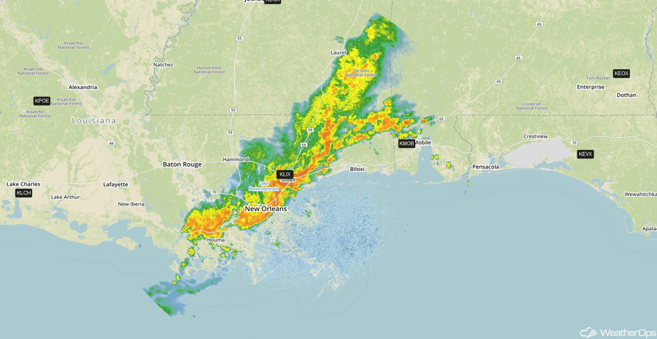 Radar 11:24am CDT
Update 12:03pm CDT: Tornado Warning in Southern Mississippi.
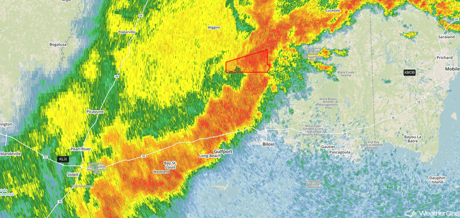 Radar 12:03pm CDT
Update 12:32pm CDT: Thunderstorms capable of damaging winds in southern Alabama.
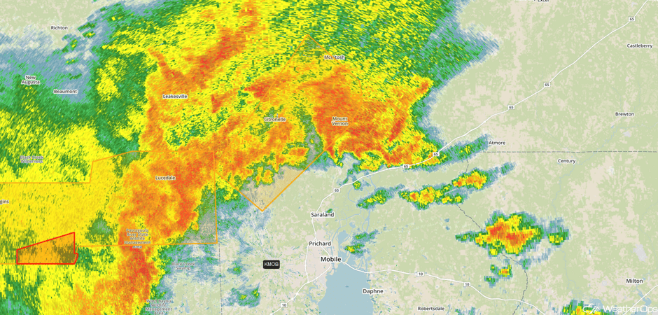 Radar 12:32pm CDT
Update 1:15pm CDT: Severe thunderstorms capable of damaging winds approaching Mobile, AL.
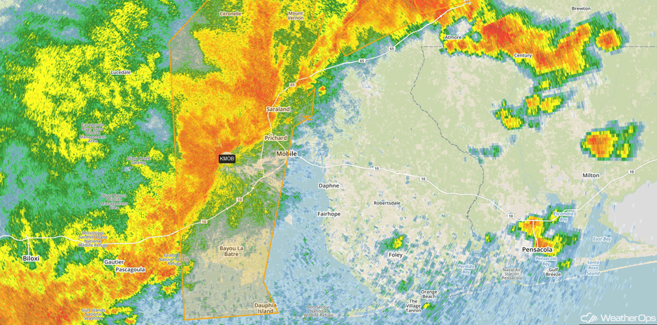 Radar 1:15pm CDT
Major Cities in Region: Baton Rouge, LA, Jackson, MS, New Orleans, LA, Mobile, AL, Birmingham, AL, Montgomery, AL, Atlanta, GA, Myrtle Beach, SC
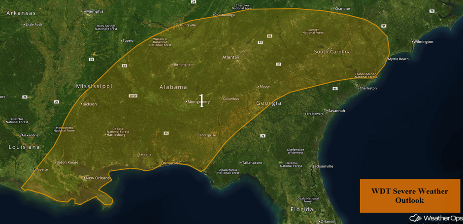 Region 1
Thunderstorm Potential Friday across Montana
As an upper level disturbance tracks eastward across the Pacific Northwest, a cold front will track across Montana during the afternoon. With daytime heating creating instability and the position of the cold front, scattered showers and thunderstorms are expected to increase in coverage and intensity with a few of these storms becoming strong to severe. Large hail and strong wind gusts will be possible with any of the stronger storms.
Major Cities in Region: Helena, MT, Great Falls, MT
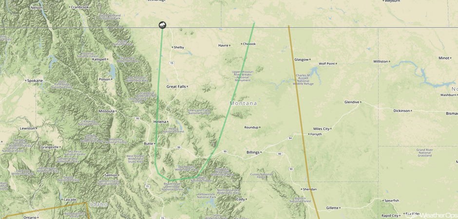 SPC Convective Outlook for Friday
Excessive Rainfall for the Mid Atlantic Friday
A stalled front will remain draped across the Southeast during the morning hours on Friday. As we get into the afternoon and evening hours, an area of low pressure is expected to develop just offshore the Carolinas along this boundary. This low is forecast to move northeastward, continuing to bring ample moisture into the Mid Atlantic and Southeast. With this low providing lift, moderate to heavy rainfall will begin to increase in coverage across the Mid Atlantic tonight as the low begins to strengthen. Rainfall amounts of 0.50-1.00 inch with locally heavier amounts in excess of 2 inches are forecast. With the ground already saturated, there will be an increased risk of flash flooding and excessive runoff overnight.
Major Cities in Region: Richmond, VA, Washington, DC
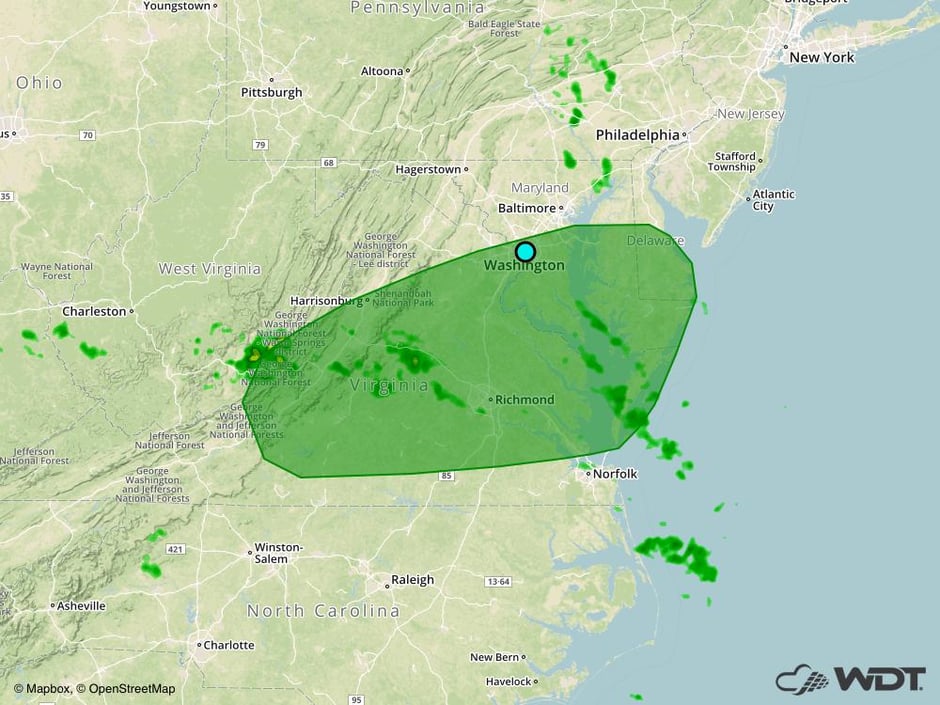 Excessive Rainfall Risk Outline for Friday
Risk for Excessive Rain across the Northeast on Saturday
The area of low pressure that is expected to develop off the East Coast Friday evening will continue to intensify and track northeastward on Saturday. As it does, ample moisture will move into the Northeast, resulting in heavy to excessive rainfall across the region. Forecast guidance suggests that general rainfall amounts of 1-2 inches with locally heavier amounts in excess of 3 inches are possible. The heaviest amounts will be along the coastline. This will result in an increase risk for flooding and excessive runoff. In addition to the heavy rain, strong winds along the coast could also increase the risk for downed trees and power lines as well.
Major Cities in Region: Philadelphia, PA, Atlantic City, NJ, New York City, NY, Providence, RI, Boston, MA
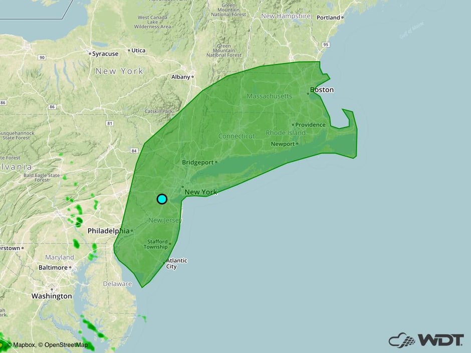 Excessive Rainfall Risk Outline for Saturday
Strong to Severe Thunderstorms Possible Saturday for Florida and Georgia
As a cold front approaches Florida and Georgia, ample low level moisture combined with some modest instability will lead to an increase in showers and thunderstorm activity just ahead of the front Saturday afternoon and evening. Some of these storms could be strong to severe with hail and damaging winds the primary hazards with any of the stronger storms.
Major Cities in Region: Jacksonville, FL, Savannah, GA
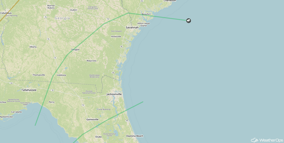 SPC Convective Outlook for Saturday
Excessive Rainfall Potential Sunday across New England
A strong area of low pressure near Cape Cod will continue to track northeastward toward the Canadian Maritimes Sunday into Monday. As this occurs, heavy to excessive rainfall will fall across portions of New England on Sunday. Rainfall totals of 1-2 inches with locally higher amounts in excess of 3 inches are forecast, resulting in an increased risk for flooding and excessive runoff.
Major Cities in Region: Portland, ME, Augusta, ME, Bangor, ME
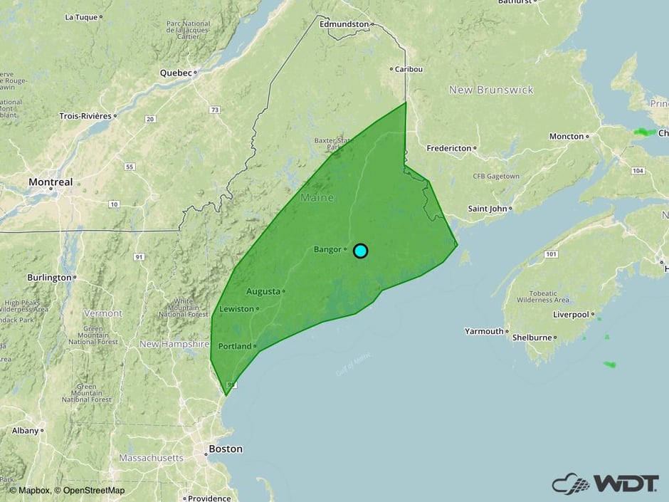 Excessive Rainfall Risk Outline for Sunday
A Look Ahead
Thunderstorms may develop across portions of the Plains on Tuesday, ahead of a dryline. Some of these storms may become severe. There will be another potential for thunderstorms Wednesday, primarily across the Southern Plains.
This is just a brief look at current weather hazards. We can provide you site-specific weather forecast information for the purpose of protecting your personnel and assets and to assess your weather risk. Try a 7-day demo right away and learn how timely precision weather information can enhance your bottom line.


