


by David Moran, on May 11, 2018 10:57:55 AM
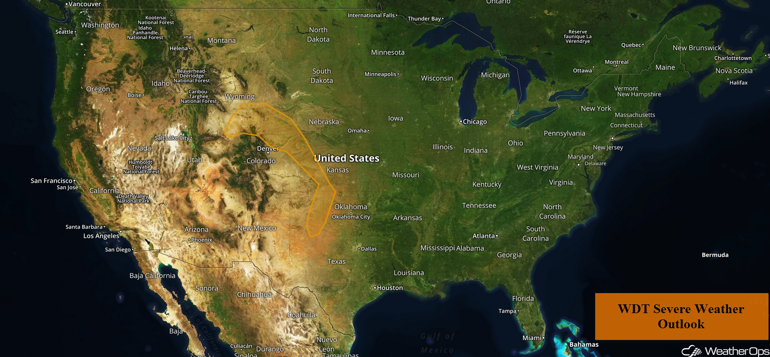
As a trough digs southward over the western US on Friday, there will be a risk for thunderstorms over the Central High Plains. A dryline will be the focus for thunderstorm development across the Oklahoma and Texas Panhandles Friday into Saturday. Thunderstorms may develop over the Ohio Valley as an area of low pressure moves across the region.
- Thunderstorms for the Central High Plains on Friday
- Potential for Thunderstorms Friday and Saturday across the Oklahoma and Texas Panhandles
- Risk for Thunderstorms across the Ohio Valley on Friday
- Excessive Rainfall Saturday for Northern Portions of Illinois and Indiana
- Thunderstorms from the Midwest to the Mid Atlantic on Saturday
- Risk for Thunderstorms Sunday across the Central High Plains
- Thunderstorm Potential for the Southern Plains on Sunday
- Thunderstorms Sunday for the Ohio Valley
 US Hazards

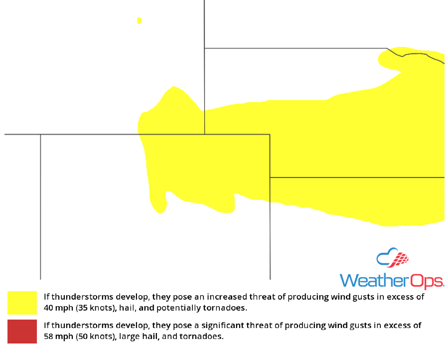
Thunderstorms for the Central High Plains on Friday
A trough over the western US will slowly dig southward on Friday. Downstream from the trough, strong southwesterly flow aloft will promote scattered thunderstorm development over the Central High Plains by late afternoon. Storm activity will initially develop over southeast Wyoming and then spread eastward into Nebraska and Colorado. Severe winds and large hail will be the primary hazards. Some activity may persist into the overnight hours with the threat for severe winds continuing.
Major Cities in Region: Denver, CO, Cheyenne, WY, Grand Island, NE
 Thunderstorm Risk for Friday
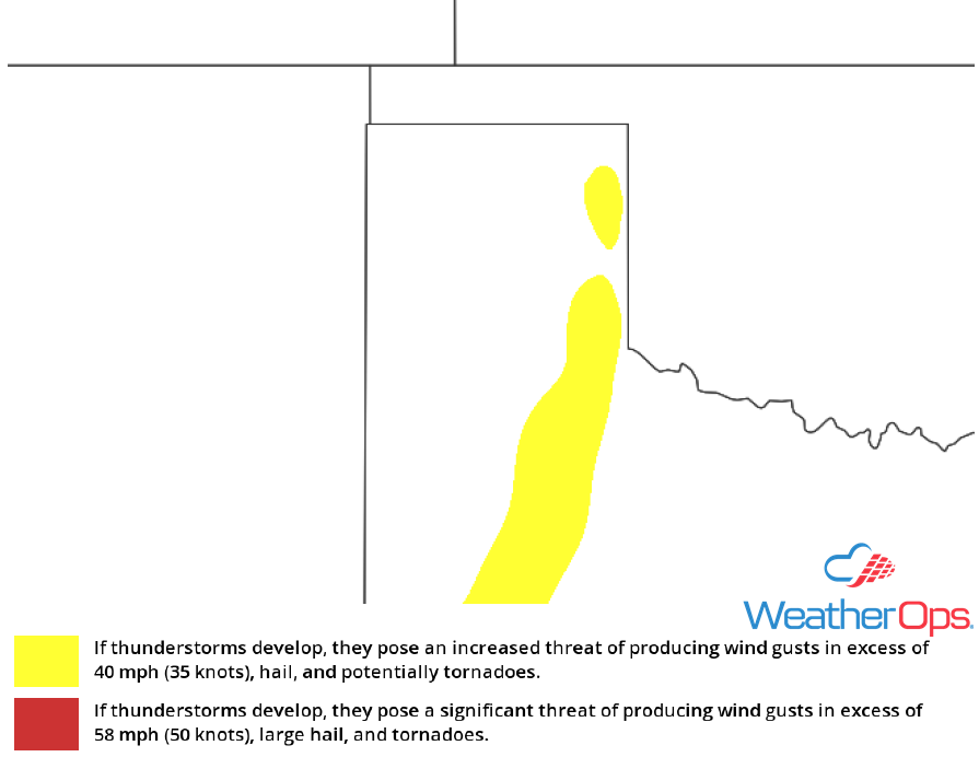
Potential for Thunderstorms Friday and Saturday across the Oklahoma and Texas Panhandles
A dryline will persist over the Oklahoma and Texas Panhandles over the next several days. Instability ahead of the dryline should be sufficient for the development of thunderstorms. While coverage will be limited, there will be a potential for thunderstorms capable of hail and damaging winds both Friday and Saturday.
Major Cities in Region: Pampa, TX, Childress, TX
 Thunderstorm Risk for Friday and Saturday
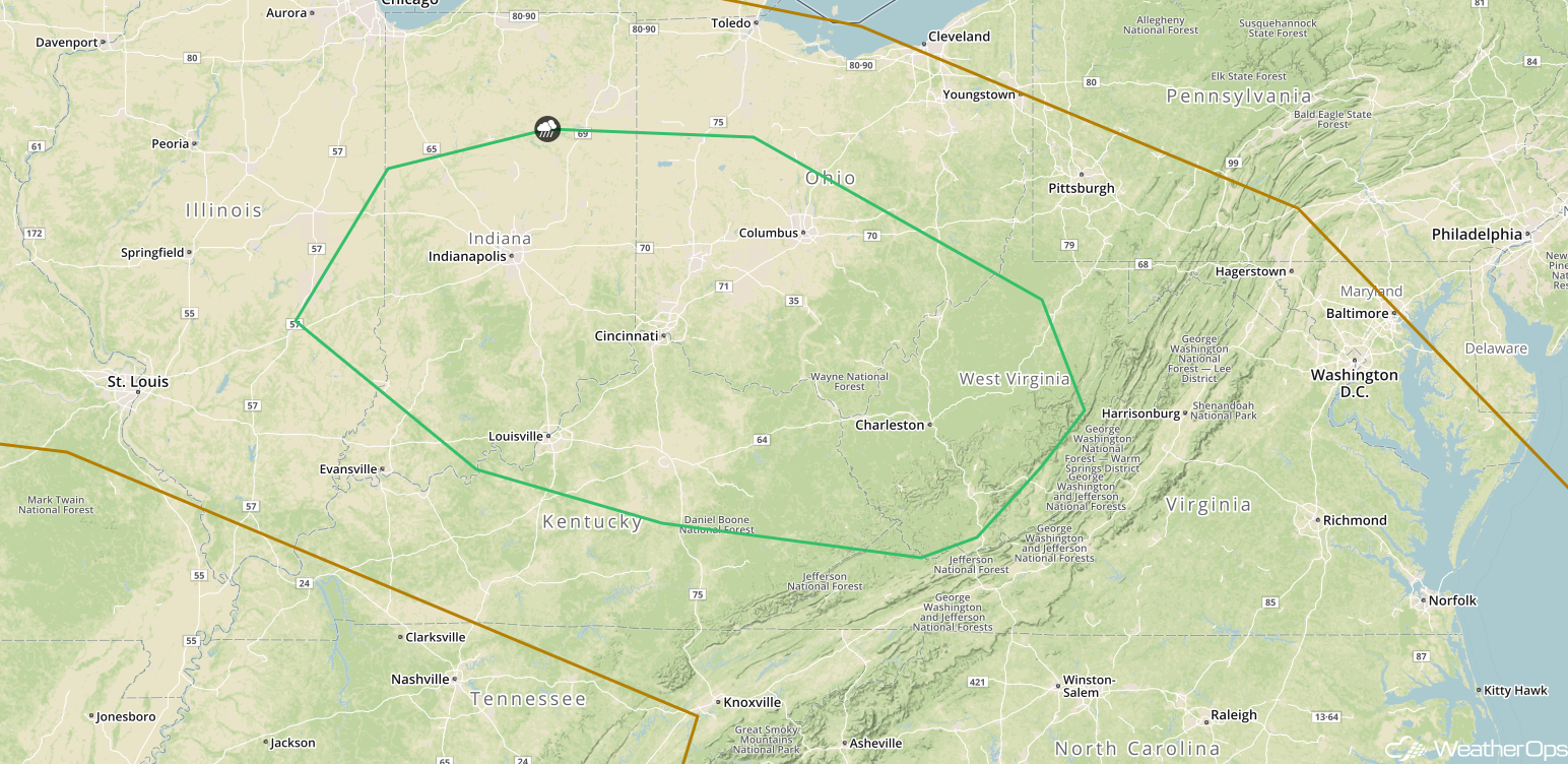
Risk for Thunderstorms across the Ohio Valley on Friday
An area of low pressure is forecast to track along a developing front over the central US this afternoon. Ongoing shower and thunderstorm activity will continue across the Midwest and perhaps increase in coverage. Marginally severe storms may develop and track into the Ohio Valley late in the day with a threat for damaging winds from eastern Ohio to West Virginia.
Major Cities in Region: Dayton, OH. Cleveland, OH, Charleston, WV
 Thunderstorm Risk for Friday
Excessive Rainfall Saturday for Northern Portions of Illinois and Indiana
Multiple rounds of showers and thunderstorms are expected to persist through Saturday. Two day rainfall totals of 1-2 inches with locally higher amounts in excess of 3 inches are forecast. This will allow for the potential for excessive rainfall on Saturday, leading to the risk for minor flooding and local runoff.
Major Cities in Region: Chicago, IL, South Bend, IN, Fort Wayne, IN
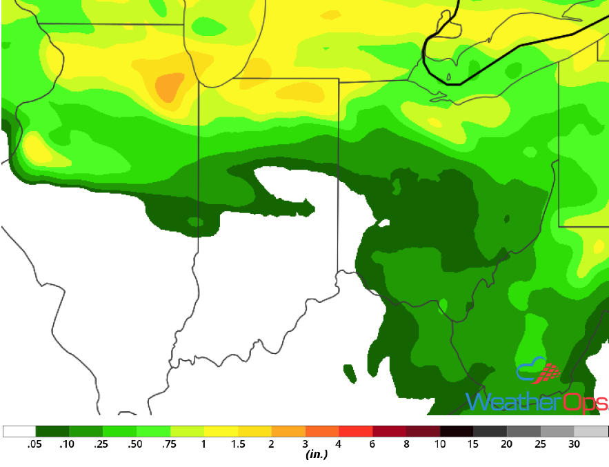 Rainfall Accumulation for Saturday
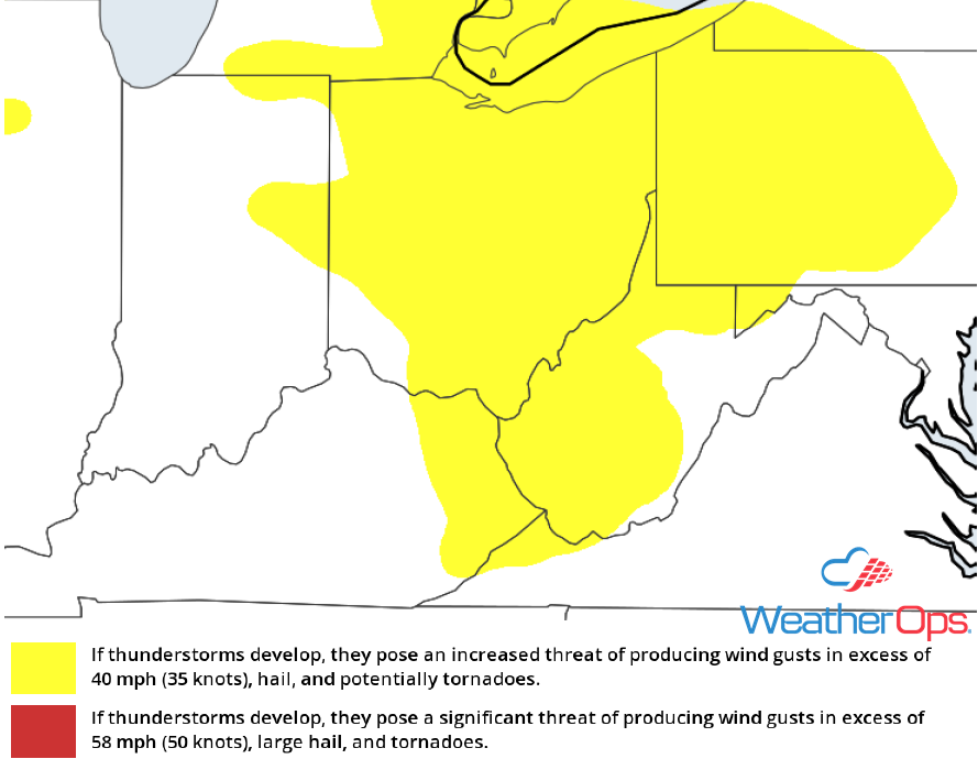
Thunderstorms from the Midwest to the Mid Atlantic on Saturday
Thunderstorms may develop from portions of the Midwest into the Mid Atlantic on Saturday ahead of a cold front. A few thunderstorms may become severe with severe winds and large hail the primary hazards, An isolated tornado or two cannot be ruled out.
Major Cities in Region: Des Moines, IA, Chicago, IL, Indianapolis, IN, Columbus, OH, Cleveland, OH, Pittsburgh, PA, Philadelphia, PA
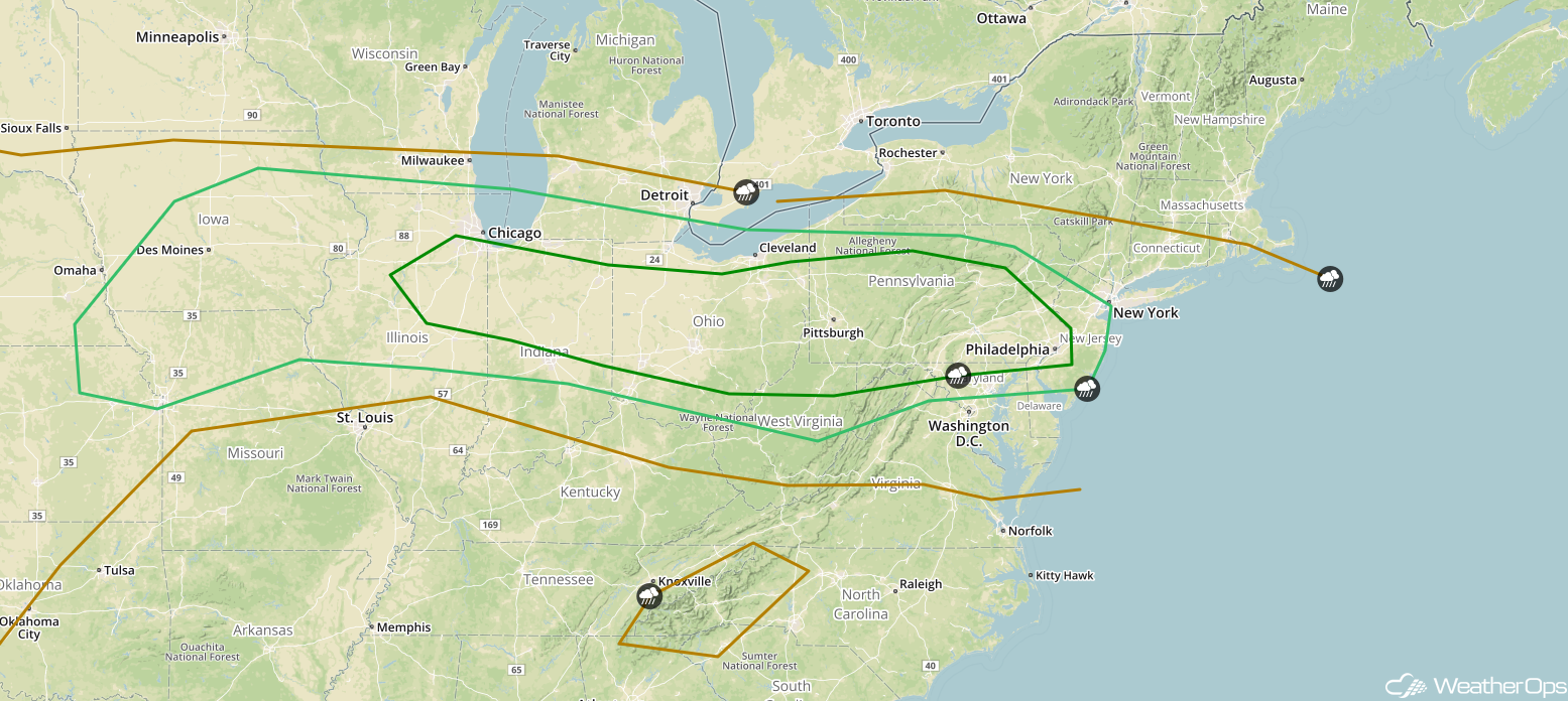 SPC Convective Outlook for Saturday
Risk for Thunderstorms Sunday across the Central High Plains
The severe weather risk will continue for portions of the Plains into Sunday as a result of a cut off low. This low will contribute to strong wind shear and forcing across the region. While moisture and instability will be lacking, a few thunderstorms capable of severe winds and large hail may develop.
Major Cities in Region: Casper, WY, Cheyenne, WY, Denver, CO, Goodland, KS
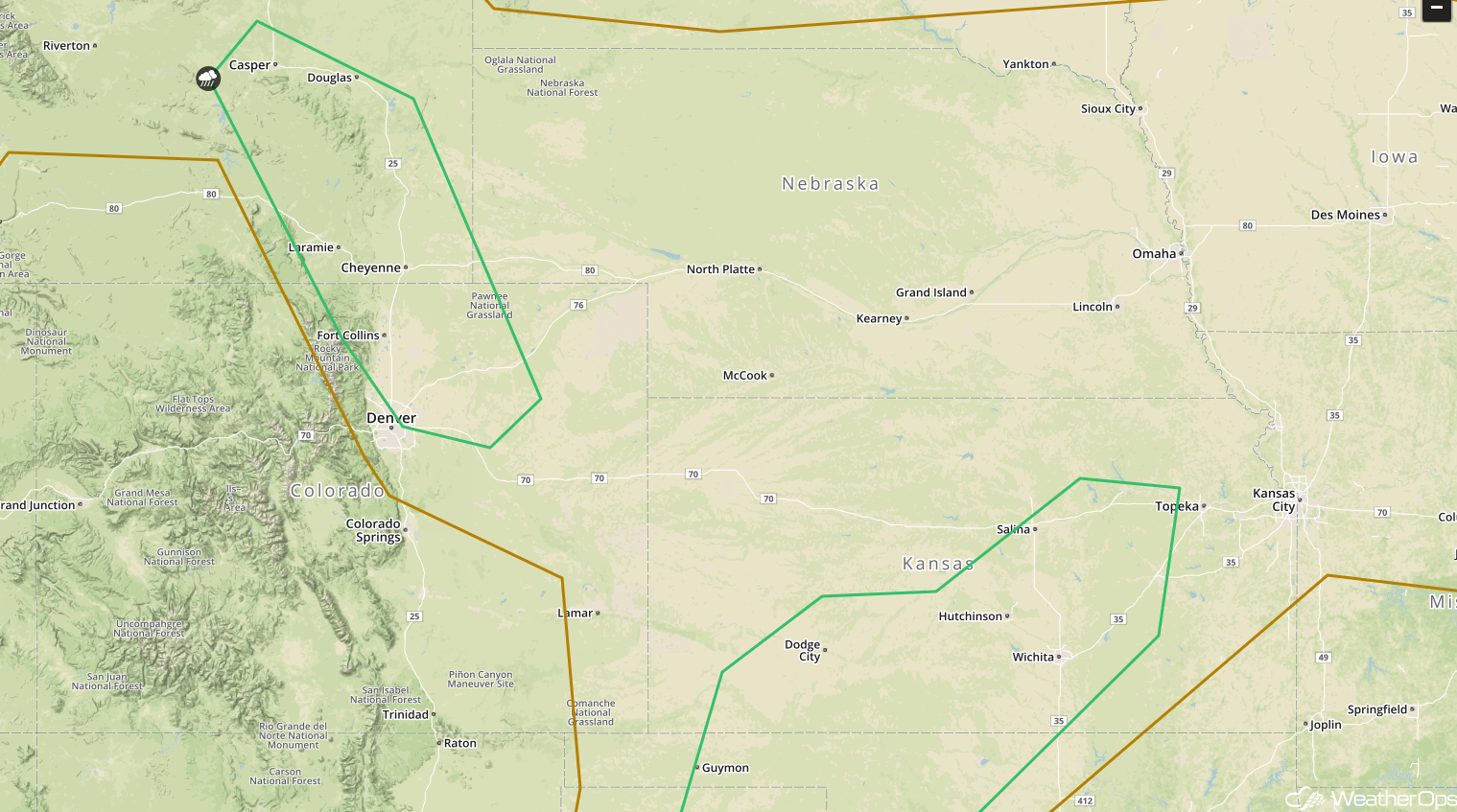 SPC Convective Outlook for Sunday
Thunderstorm Potential for the Southern Plains on Sunday
Strong daytime heating along a dryline may contribute to isolated thunderstorm development Sunday afternoon and evening from south central Kansas into Northwest Texas. Storms that develop will have the potential to produce large hail and damaging winds. An isolated tornado or two cannot be ruled out.
Major Cities in Region: Lubbock, TX, Amarillo, TX, Dodge City, KS, Salina, KS, Wichita, KS
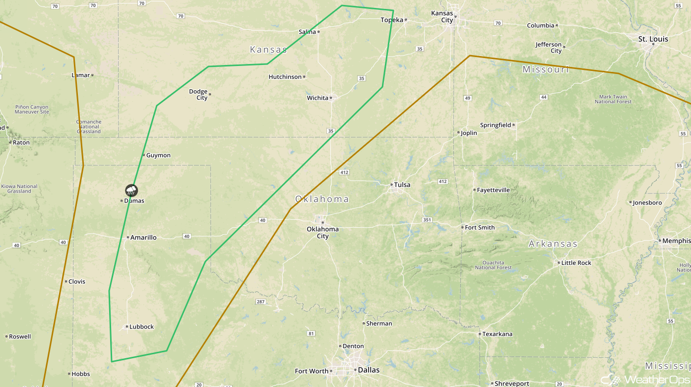 SPC Convective Outlook for Sunday
Thunderstorms Sunday for the Ohio Valley
There will be a risk for thunderstorms on Sunday across the Ohio Valley along a stalled front. As thunderstorms develop, some may be severe with hail and damaging winds the primary hazards.
Major Cities in Region: Indianapolis, IN, Louisville, KY, Cincinnati, OH, Columbus, OH, Charleston, WV
 SPC Convective Outlook for Sunday
A Look Ahead
Showers and thunderstorms are forecast across portions of the Central and Southern Plains on Monday as an area of low pressure develops. This activity will move into the Upper Midwest on Tuesday. By late Wednesday, thunderstorms may develop across portions of western Oklahoma and Northwest Texas.
This is just a brief look at current weather hazards. We can provide you site-specific weather forecast information for the purpose of protecting your personnel and assets and to assess your weather risk. Try a 7-day demo right away and learn how timely precision weather information can enhance your bottom line.
