


by David Moran, on Jun 8, 2018 11:07:20 AM
A series of disturbances moving across portions of the Northern and Central Plains into the Midwest will bring a risk of thunderstorms to the region on Friday. Some of these thunderstorms may produce heavy to excessive rainfall across the Midwest. Thunderstorms will continue across Central and Southern Florida.
- Thunderstorms Friday from the Northern and Central Plains into the Midwest
- Excessive Rainfall for the Midwest Friday
- Risk for Thunderstorms Friday across Central and Southern Florida
- Potential for Thunderstorms from the Upper Midwest to the Mid Atlantic Saturday
- Thunderstorm Risk Saturday from the Northern Rockies into the Northern and Central Plains
- Thunderstorms across the Northern Plains Sunday
- Risk for Thunderstorms on Sunday from the Mid Mississippi Valley into the Ohio Valley
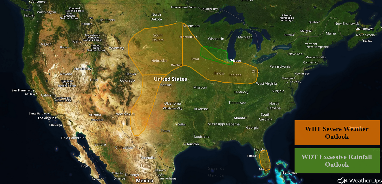 US Hazards

Thunderstorms Friday from the Northern and Central Plains into the Midwest
An area of low pressure and a stalled front will be the focus for severe thunderstorm development this afternoon and into the overnight hours. A series of upper level disturbances within the jet stream will provide additional forcing for the development of these storms. Thunderstorms are expected to form along the front from Iowa eastward into Ohio and Kentucky during the afternoon and evening. Damaging winds and large hail will be the primary hazards with these storms. Further to the west, storms will begin to develop across the Western Plains late in the afternoon and move into the Northern and Central Plains during the evening and overnight hours. Large hail and damaging winds will be the primary hazards as storms develop, but as storms evolve into a line, the primary hazard will become damaging winds.
Major Cities in Region: Scottsbluff, NE, Rapid City, SD, Pierre, SD, Sioux Falls, SD, Omaha, NE, Des Moines, IA, Chicago, IL, Indianapolis, IN, Columbus, OH
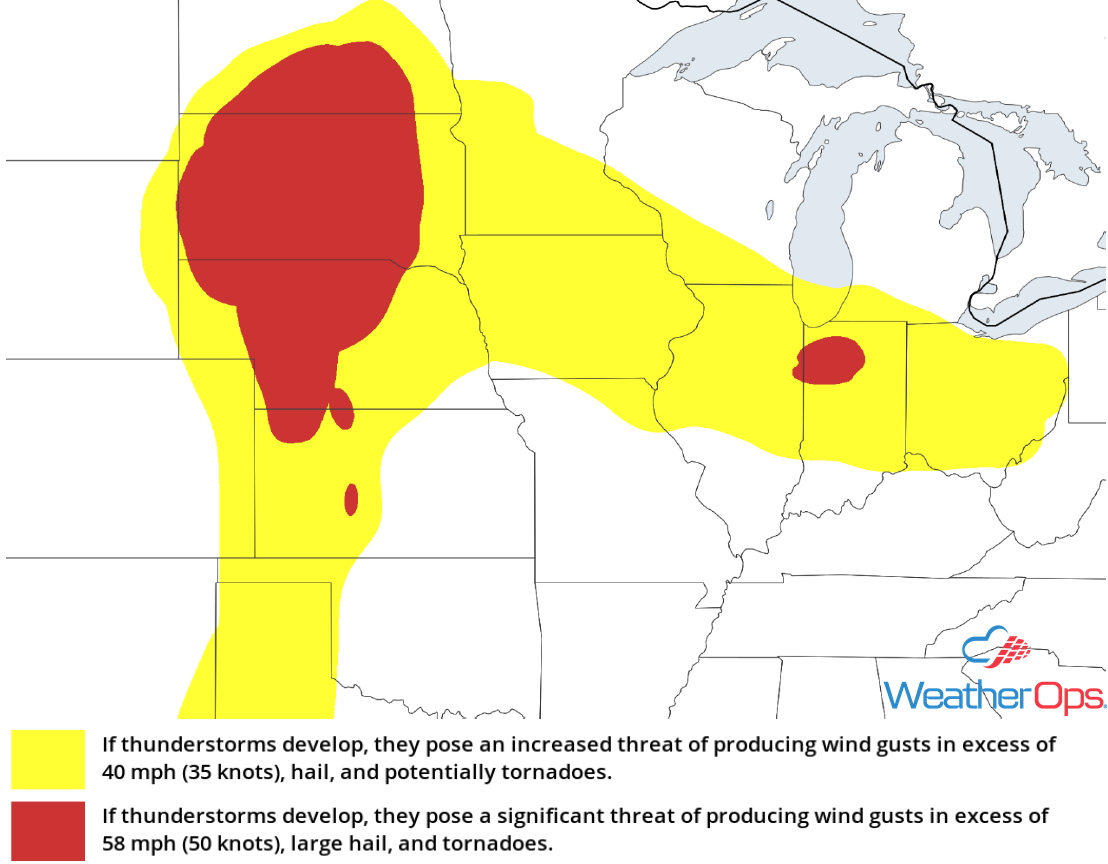 Thunderstorm Risk for Friday
Excessive Rainfall for the Midwest Friday
While confidence is increasing that excessive rainfall will occur across portions of the Midwest on Friday, there is still uncertainty in the specific details. Thunderstorms will continue across the region through the morning, but a more substantial complex will likely develop during the evening. Within this complex, rainfall amounts will range 1-2 inches with locally higher amounts. The highest risk for flash flooding will be across eastern portions of Nebraska and South Dakota into western Iowa.
Major Cities in Region: Pierre, SD, Sioux City, IA, Omaha, NE, Minneapolis, MN, Milwaukee, WI, Chicago, IL
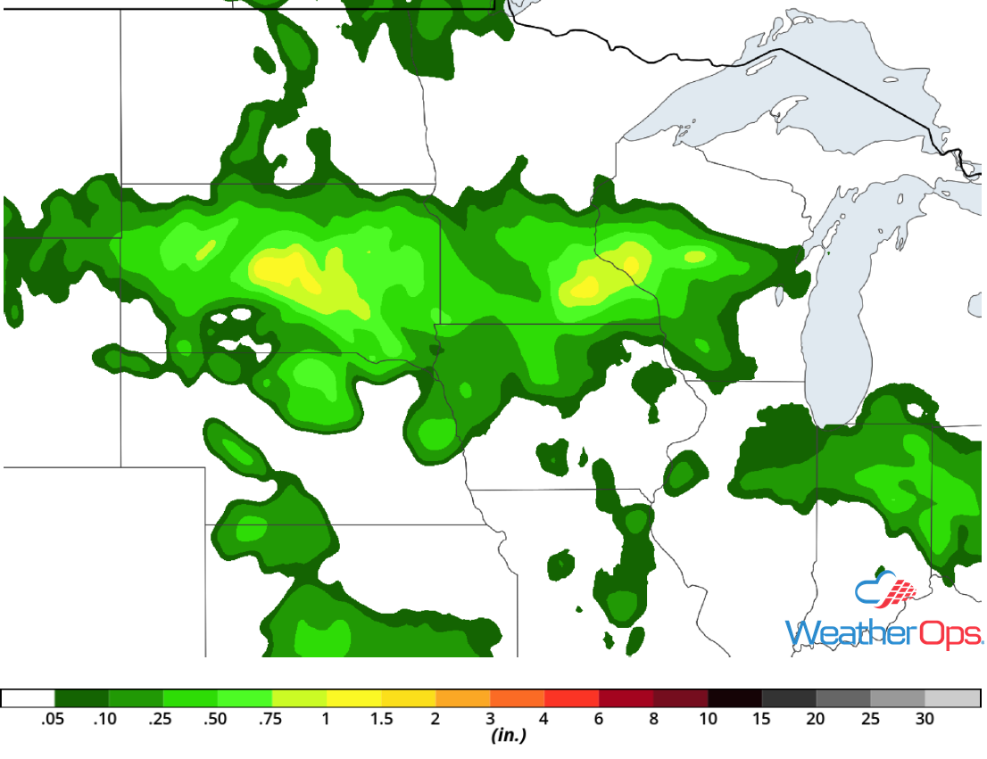 Rainfall Accumulation for Friday
Risk for Thunderstorms Friday across Central and Southern Florida
An upper level low centered over the northeast Gulf of Mexico will continue to generate thunderstorms across much of Florida today. Aided by a sea breeze moving inland, conditions should become favorable for the development of a few strong to severe thunderstorms. Gusty winds and hail will be the primary hazards with the stronger storms. Most of this activity is expected during the afternoon and evening before weakening and diminishing after sunset.
Major Cities in Region: Orlando, FL, Palm Beach, FL, Miami, FL
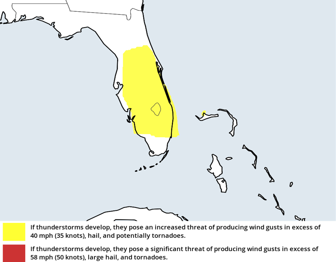 Thunderstorm Risk for Friday
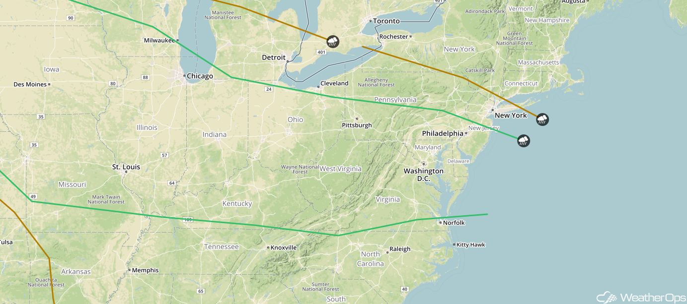
Thunderstorms are forecast from the Upper Midwest into the Mid Atlantic on Saturday, though details still remain uncertain. Activity that develops tonight will likely leave behind outflow boundaries. These boundaries will be the focus for the development of thunderstorms on Saturday. Scattered thunderstorms are expected to develop along a front extending from the Upper Midwest to the East Coast during the afternoon and early evening. An upper level disturbance is forecast to move out of the Northern Plains Saturday night, allowing clusters of storms to continue after dark. Damaging winds will be the primary hazards with these storms.
Major Cities in Region: Des Moines, IA, St. Louis, MO, Chicago, IL, Indianapolis, IN, Cincinnati, OH, Charleston, WV, Washington, DC, Philadelphia, PA
 SPC Convective Outlook for Saturday
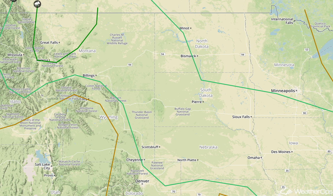
An upper level disturbance and a cold front will allow for the development of strong to severe thunderstorms across Montana by late Saturday afternoon. Damaging winds and large hail will be the primary hazards with these storms, but an isolated tornado cannot be ruled out. Across the Northern and Central Plains, the thunderstorm potential will depend on when the upper level disturbance moves into the region. If storms are able to develop, hail and damaging winds will be the primary hazards.
Major Cities in Region: Helena, MT, Great Falls, MT. Billings, MT, North Platte, NE, Pierre, SD, Sioux Falls, SD, Omaha, NE
 SPC Convective Outlook for Saturday
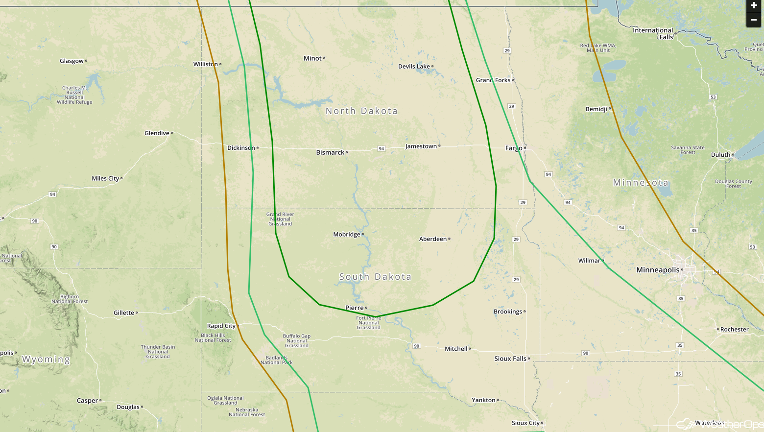
A strong upper level disturbance and cold front will move out of the Northern Rockies and into the Northern Plains on Sunday. Thunderstorms are likely to develop along and ahead of the front across the Dakotas Sunday afternoon. High instability and strong wind shear will support the potential for large hail, damaging winds, and tornadoes. Storms may continue into western Minnesota overnight. By this time, damaging winds will be the primary hazard.
Major Cities in Region: Minot, ND, Bismarck, ND, Pierre, SD, Sioux Falls, SD, Sioux City, IA
 SPC Convective Outlook for Sunday
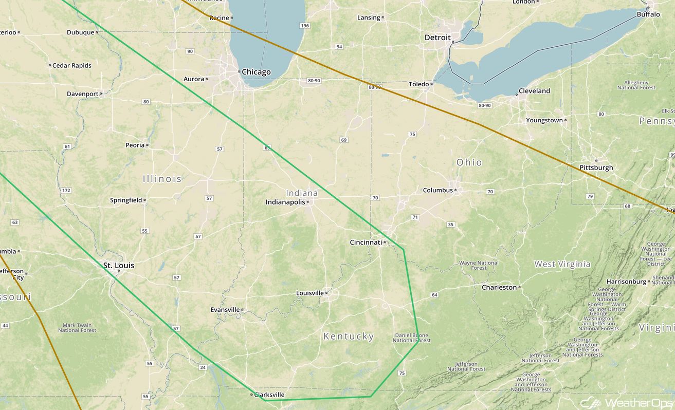
Risk for Thunderstorms on Sunday from the Mid Mississippi Valley into the Ohio Valley
Conditions will be favorable for the development of showers and thunderstorms along a stalled frontal boundary on Sunday. A few storms may be strong to severe with damaging winds and large hail the primary hazards with any storms that develop.
Major Cities in Region: Cedar Rapids, IA, St. Louis, MO, Evansville, IN, Indianapolis, IN, Louisville, KY, Cincinnati, OH
 SPC Convective Outlook for Sunday
A Look Ahead
Showers and thunderstorms will extend from the Northern Plains into the Great Lakes on Monday as an area of low pressure moves eastward. By Tuesday, showers will extend from the Ohio Valley into the Plains. An area of low pressure may develop across the Plains on Wednesday, bringing a risk for showers and thunderstorms to portions of the Plains. Additional thunderstorms may develop across the Plains on Thursday.
This is just a brief look at current weather hazards. We can provide you site-specific weather forecast information for the purpose of protecting your personnel and assets and to assess your weather risk. Try a 7-day demo right away and learn how timely precision weather information can enhance your bottom line.
