


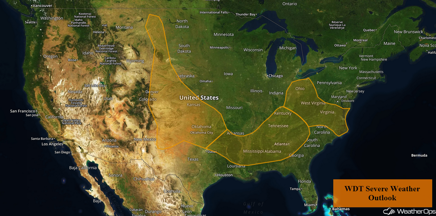
by David Moran, on Jun 22, 2018 11:54:15 AM
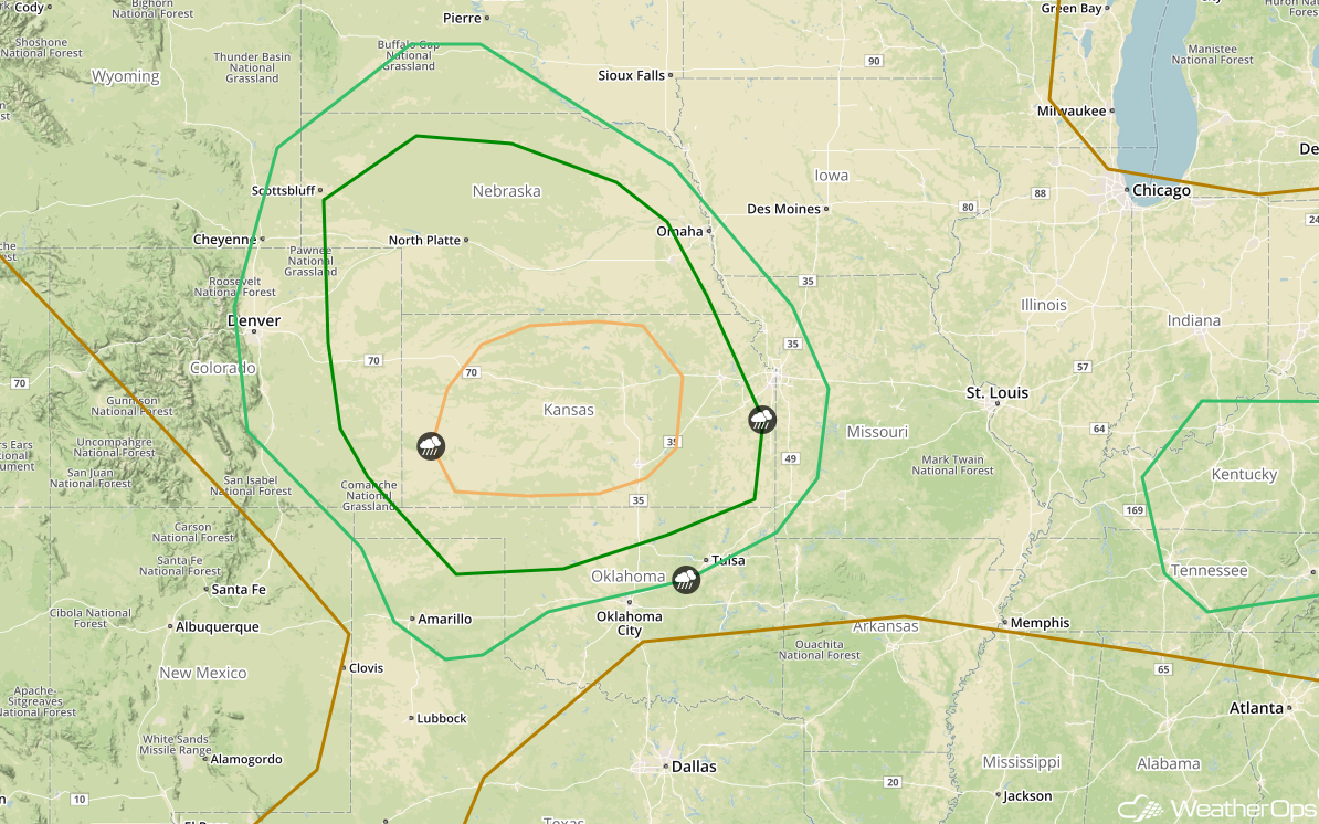
Thunderstorms are forecast across the Front Range into the Southern Plains on Friday as an area of low pressure develops. As this area of low pressure stalls over the Texas Panhandle, there will be a potential for excessive rainfall across the Southern Plains through Saturday. An area of low pressure and associated cold front will continue to move eastward, allowing for the development of thunderstorms across the Southeast into the Ohio Valley. As this area of low pressure continues to move eastward, there will be a risk for excessive rainfall from the Ohio River Valley into the Mid Atlantic. A cold front will stall across the Lower Mississippi River Valley, allowing for the potential for excessive rainfall.
- Potential for Thunderstorms Friday from the Front Range into the Southern Plains
- Risk of Excessive Rainfall across the Southern Plains through Saturday
- Thunderstorms Friday across the Southeast and Ohio Valley
- Excessive Rainfall from the Ohio Valley into the Mid Atlantic on Friday
- Potential for Excessive Rainfall Friday across the Lower Mississippi Valley
- Thunderstorms for the Southern Plains on Saturday
- Risk for Thunderstorms Saturday across the Mid Atlantic
- Thunderstorm Potential for the Central Plains on Sunday
- Excessive Rainfall Sunday for the Central Plains
- Potential for Thunderstorms across Kentucky and Tennessee Sunday
 US Hazards

Potential for Thunderstorms Friday from the Front Range into the Southern Plains
An upper level trough will track across Montana and into the Plains today. At the surface, an area of low pressure is forecast to develop during the late morning across the Front Range and track southeastward into the Texas Panhandle tonight. Daytime heating will increase instability across the region. This instability, combined with ample low level moisture, upslope flow, and increasing wind shear will allow for the development of strong to severe thunderstorms. Large hail, damaging winds, and tornadoes will all be potential hazards with these storms during the afternoon and evening. As these storms continue to move eastward overnight, they will merge into clusters with damaging winds the primary hazard.
Major Cities in Region: Denver, CO, Goodland, KS, Guymon, OK, Amarillo, TX, Dodge City, KS, Oklahoma City, OK, Wichita, KS, Tulsa, OK
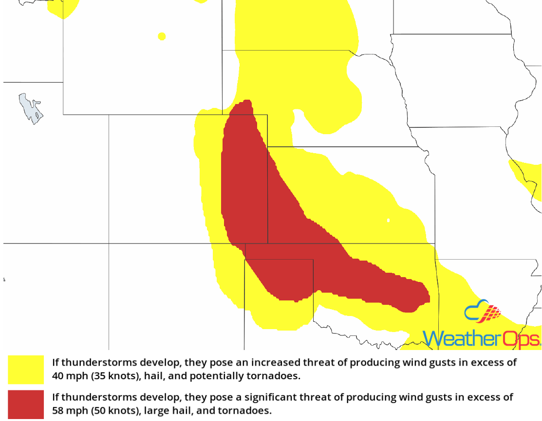 Thunderstorm Risk for Friday
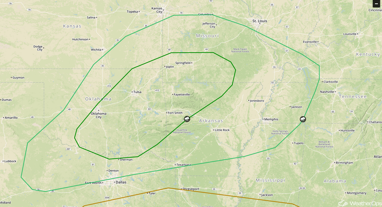
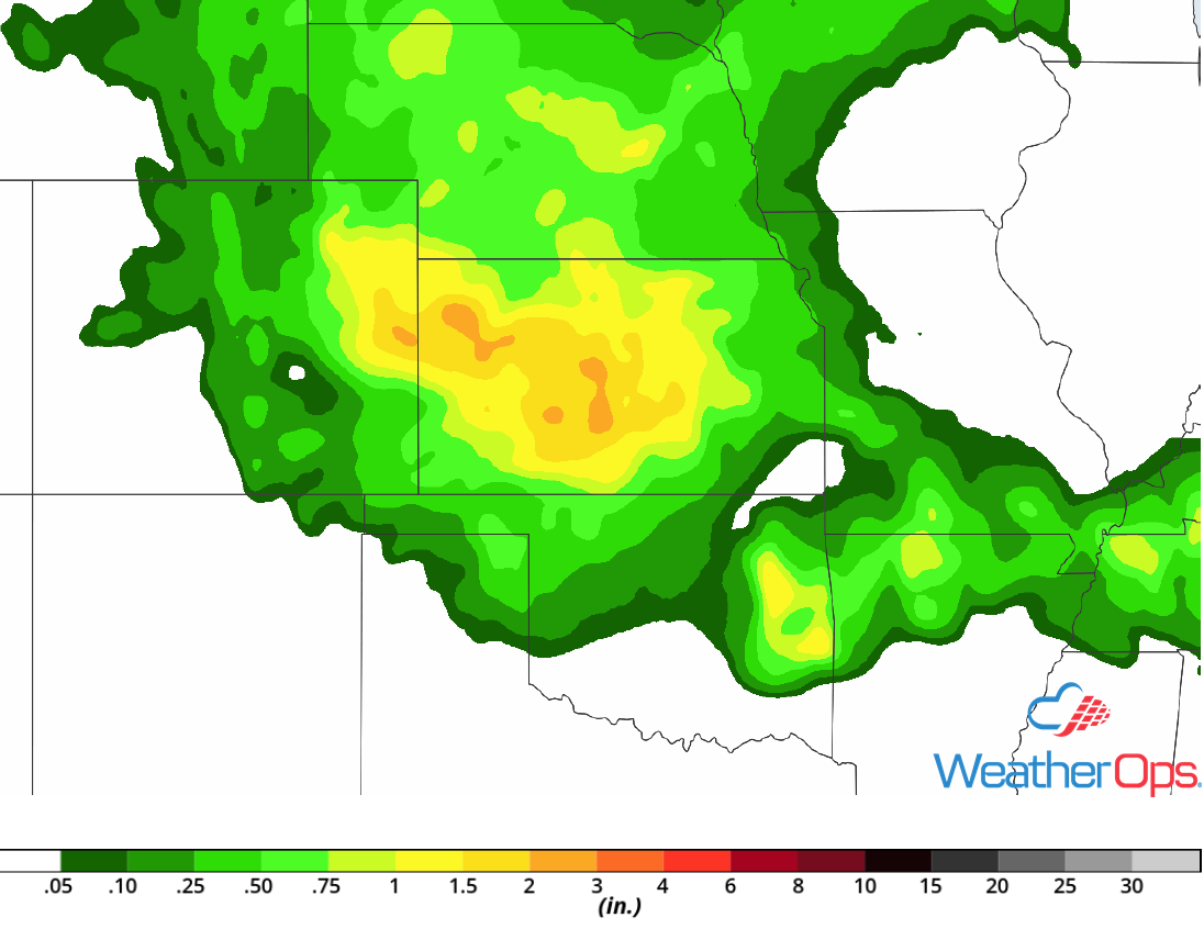
Risk of Excessive Rainfall across the Southern Plains through Saturday
The area of low pressure described above will move little through Saturday. Its associated warm front will extend into Arkansas with southerly flow to the south pumping moisture into the region. With this moisture in place, multiple rounds of showers and thunderstorms will track along the warm front Friday evening into Saturday. Any thunderstorm that develops will have the potential to produce very heavy rainfall. Rainfall amounts of 1-3 inches with locally higher amounts in excess of 4 inches are expected, leading to a risk for flash flooding and runoff.
Major Cities in Region: Wichita, KS, Tulsa, OK, Fayetteville, AR
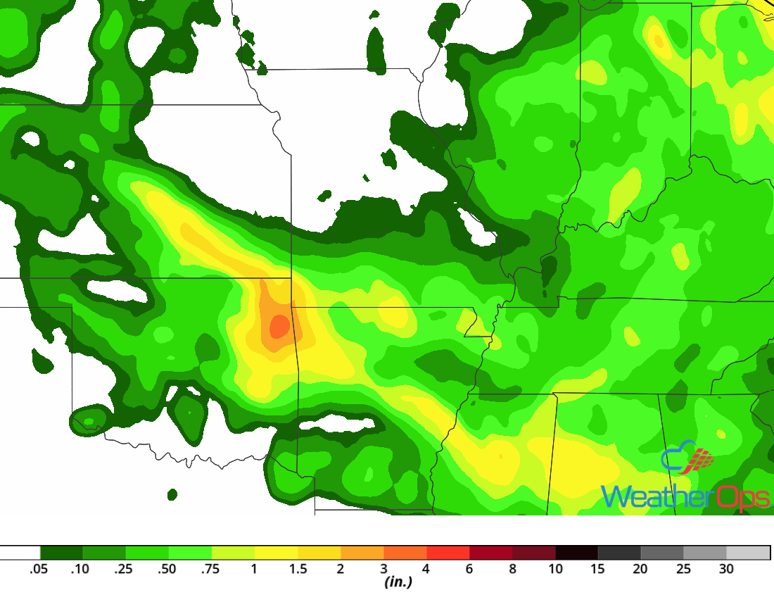 Rainfall Accumulation through Saturday
Thunderstorms Friday across the Southeast and Ohio Valley
An area of low pressure will continue to track eastward across the Midwest and into the Ohio Valley today with the associated cold front tracking to the east or southeast. Ongoing showers and thunderstorms may limit thunderstorm development this afternoon, however, instability is expected to build as a result of southerly flow and daytime heating. With lift provided by the cold front, strong to severe thunderstorms are forecast to develop this afternoon. Large hail, damaging winds, and tornadoes will all be potential hazards with these storms. Further east, daytime heating may allow for development of severe thunderstorms capable of producing strong winds.
Major Cities in Region: Jackson, MS, Evansville, IN, Birmingham, AL, Nashville, TN, Louisville, KY, Cincinnati, OH, Charleston, WV
 Thunderstorm Risk for Friday
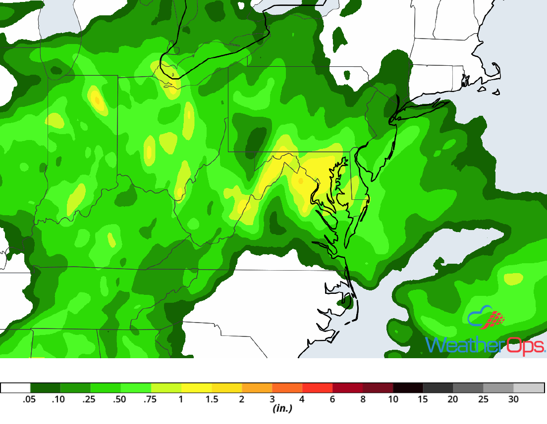
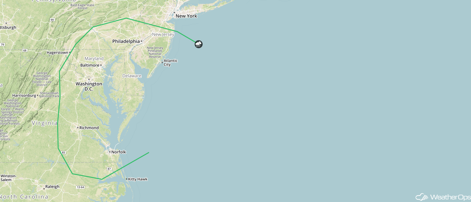
Excessive Rainfall from the Ohio Valley into the Mid Atlantic on Friday
A slow moving area of low pressure will continue to track eastward today. Southerly flow ahead of and to the south of this system will bring moisture northward, allowing for the development of multiple rounds of showers and thunderstorms. This will allow for heavy to excessive rainfall from the Ohio River Valley into the Mid Atlantic. Rainfall accumulations will range 0.75-1.50 inches with locally higher amounts in excess of 2 inches. Given the previous days' rainfall, there will be a risk for flash flooding and excessive runoff.
Major Cities in Region: Columbus, OH, Charleston, WV, Charlottesville, VA, Richmond, VA, Norfolk, VA
 Rainfall Accumulation for Friday
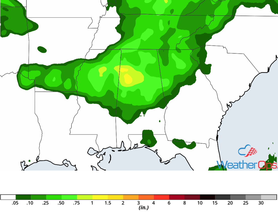
Potential for Excessive Rainfall Friday across the Lower Mississippi Valley
A slow moving cold front will stall across the Lower Mississippi Valley today. Ongoing showers and thunderstorms will train along this front. With daytime heating increasing instability and moisture being pulled northward, additional shower and thunderstorm activity is expected later today. This front will remain in place, allowing activity to continue into the overnight hours, bringing a risk for heavy to excessive rainfall. Rainfall amounts of 0.75-1.50 inches with locally higher amounts in excess of 2 inches. Given the ground is already saturated from previous days' rain, there will be an increased risk for flash flooding and excessive runoff.
Major Cities in Region: Jackson, MS, Tupelo, MS, Columbus, MS
 Rainfall Accumulation for Friday
Thunderstorms for the Southern Plains on Saturday
Ongoing strong to severe thunderstorms will track eastward across portions of the Southern Plains during the morning hours. These thunderstorms will have the potential to produce damaging winds. Later in the morning, these thunderstorms will weaken, but they will leave behind outflow boundaries. As daytime heating increases during the afternoon, additional thunderstorms are expected to develop. Damaging winds, large hail, and an isolated tornado or two will be potential hazards with the stronger storms.
Major Cities in Region: Lawton, OK, Oklahoma City, OK, Tulsa, OK, Fort Smith, AR, Fayetteville, AR, Springfield, MO
 SPC Convective Outlook for Saturday
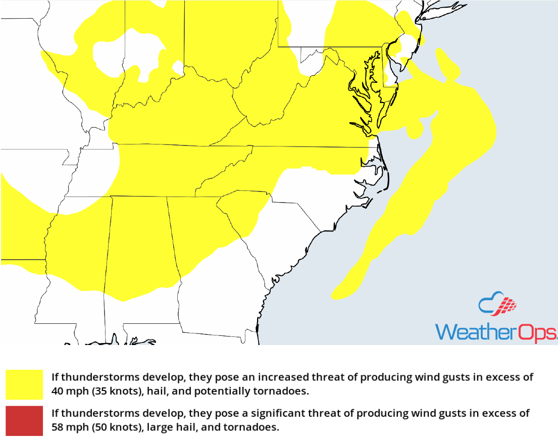
Risk for Thunderstorms Saturday across the Mid Atlantic
A warm front will lift northward during the morning on Saturday. Behind the front, warm moist air will move northward and as daytime heating increases, instability will build through the afternoon. With strong upper level winds across the region, scattered strong to severe thunderstorms are expected to develop during the afternoon and early evening. Large hail, damaging winds, and tornadoes will be potential hazards with these storms. Activity should diminish with the loss of daytime heating.
Major Cities in Region: Richmond, VA, Washington, DC, Baltimore, MD, Philadelphia, PA, Atlantic City, NJ
 SPC Convective Outlook for Saturday
Thunderstorm Potential for the Central Plains on Sunday
A strong upper level low will track across the Rockies and into the Plains on Sunday while an area of low pressure in the Texas Panhandle intensifies and the associated warm front moves northward into Kansas. This will allow warm moist air to move northward across the Plains. Instability and wind shear will increase across the region, creating an environment favorable for the development of strong to severe thunderstorms. These thunderstorms will spread eastward overnight with large hail, damaging winds, and tornadoes all potential hazards with these storms. This activity will evolve into clusters overnight and move eastward with damaging winds the primary hazard.
Major Cities in Region: Scottsbluff, NE, Goodland, KS, North Platte, NE, Dodge City, KS, Wichita, KS, Tulsa, OK, Topeka, KS, Omaha, NE, Kansas City, MO
 SPC Convective Outlook for Sunday
Excessive Rainfall Sunday for the Central Plains
In addition to the thunderstorms described above, there will be a risk for excessive rainfall. Rainfall amounts will range 2-3 inches with locally heavier amounts in excess of 4 inches. This will lead to a risk for widespread flooding and excessive runoff.
Major Cities in Region: Goodland, KS, Dodge City, KS, Wichita, KS, Salina, KS
 Rainfall Accumulation for Sunday
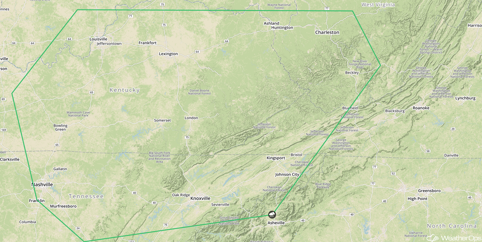
Potential for Thunderstorms across Kentucky and Tennessee Sunday
An upper level trough will track across the Tennessee Valley on Sunday, providing a focal point for shower and thunderstorm development during the afternoon. Daytime heating will increase instability across the region and with this trough providing ample lift, as well as favorable upper level winds across the region, thunderstorms will develop. Some of these storms could become strong to severe. Damaging winds and hail will be the primary hazards with the stronger storms. Shower and thunderstorm activity will quickly diminish overnight with the loss of daytime heating.
Major Cities in Region: Nashville, TN, Louisville, KY, Knoxville, TN, Charleston, WV
 SPC Convective Outlook for Sunday
A Look Ahead
Showers and thunderstorms will continue across the Plains and move into portions of the Midwest on Monday as the area of low pressure described above continues to move northeastward. This activity will move into the Great Lakes on Tuesday. On Wednesday, showers will extend from the Great Lakes into the Southeast. By Thursday, this activity will move into the Northeast.
This is just a brief look at current weather hazards. We can provide you site-specific weather forecast information for the purpose of protecting your personnel and assets and to assess your weather risk. Try a 7-day demo right away and learn how timely precision weather information can enhance your bottom line.
