


by David Moran, on Jun 15, 2018 10:50:06 AM
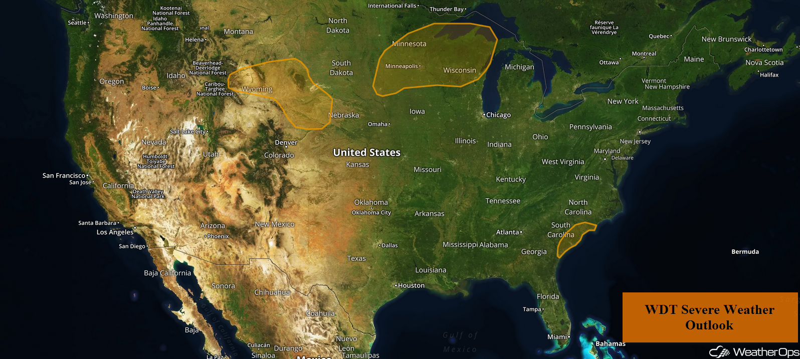
Another round of thunderstorms is forecast across portions of the Upper Midwest and Central Plains on Friday along outflow boundaries left behind by morning thunderstorm activity. Multiple rounds of showers and thunderstorms moving across the Northern Plains and Upper Midwest will pose a risk for excessive rainfall through Sunday. Thunderstorms may develop across South Carolina ahead of a weak front. As the remnants of Pacific Tropical Storm Bud continue to move northward, there will be a risk for excessive rainfall across the Southwest through Saturday.
- Thunderstorms Friday across the Upper Midwest and Central Plains
- Excessive Rainfall for the Northern Plains and Upper Midwest Friday through Sunday
- Risk for Thunderstorms Friday across South Carolina
- Potential for Excessive Rainfall across the Southwest Friday and Saturday
- Thunderstorms Saturday for the Upper Midwest into the Northern and Central Plains
- Excessive Rainfall for the Northern Rockies on Saturday
- Thunderstorm Potential Sunday for the Upper Midwest into the Central and Northern Plains
 US Hazards

Thunderstorms Friday across the Upper Midwest and Central Plains
Ongoing clusters of thunderstorms will continue through the morning hours. Some additional development may occur through the late morning, but an overall weakening trend is expected as they move eastward. A few outflow boundaries from the morning activity may allow for an additional round of thunderstorms during the late afternoon or evening as instability increases. Large hail and damaging winds will be the primary hazards, but an isolated tornado or two cannot be ruled out. Further west across the Central Plains, a few isolated supercell thunderstorms may develop ahead of a stalled front by this afternoon. Strong to damaging winds and large hail will be the main hazards with the stronger storms.
Major Cities in Region: Pierre, SD, Sioux Falls, SD, Minneapolis, MN, Duluth, MN, Green Bay, WI, Milwaukee, WI
 Thunderstorm Risk for Friday
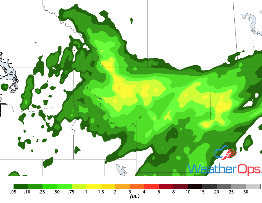
Excessive Rainfall for the Northern Plains and Upper Midwest Friday through Sunday
Multiple rounds of showers and thunderstorms are expected across the Northern Plains and Upper Midwest over the next three days and will bring a risk of heavy to excessive rainfall. Daily rainfall amounts will range 0.50-1.50 inches with locally higher amounts in excess of 2 inches. This will lead to three day rainfall totals between 1.50 and 3.00 inches with locally higher amounts in excess of 4 inches, resulting in the potential for flooding and flash flooding.
Major Cities in Region: Rapid City, SD, Pierre, SD, Sioux Falls, SD, Duluth, MN, Wausau, WI
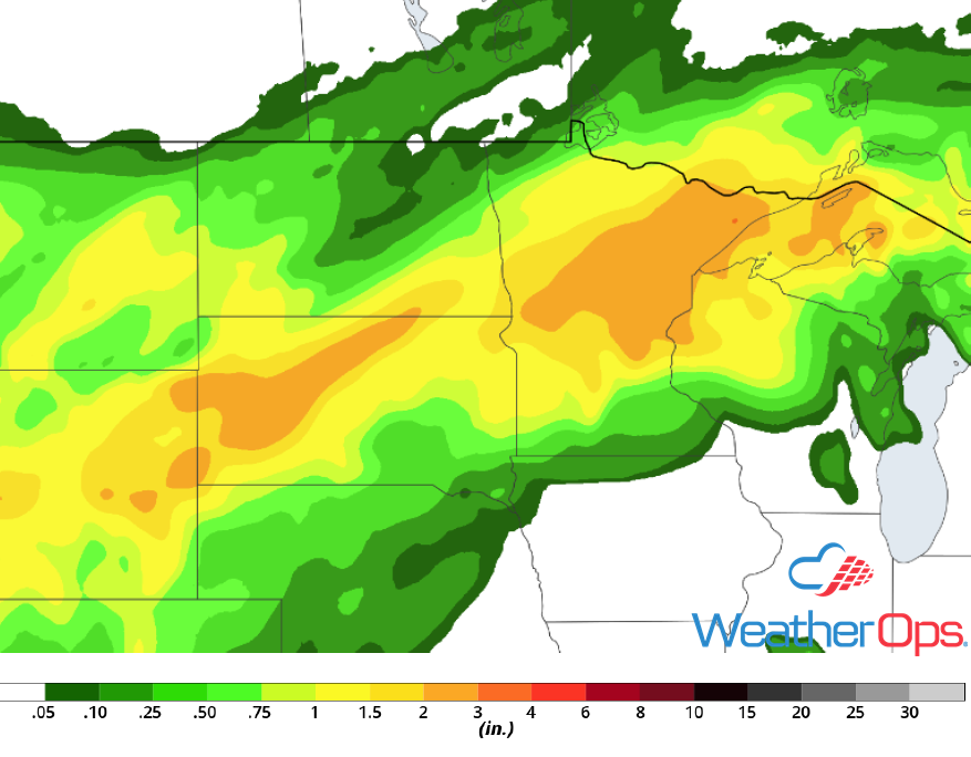 Rainfall Accumulation through Sunday
Risk for Thunderstorms Friday across South Carolina
A weak front will move southward across the region on Friday. With strong daytime heating and plentiful moisture, isolated thunderstorms are forecast to develop along the front during the late afternoon. Thunderstorms will generally move southward to southeastward with damaging winds and hail being the primary hazards.
Major Cities in Region: Columbia, SC, Myrtle Beach, SC
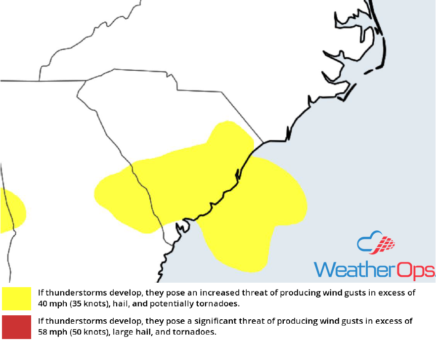 Thunderstorm Risk for Friday
Potential for Excessive Rainfall across the Southwest Friday and Saturday
As the remnants from East Pacific Tropical Storm Bud continue to move northward, heavy to excessive rainfall is forecast across the Southwest on both Friday and Saturday. Rainfall totals will range 0.25-0.50 inch with locally higher amounts in excess of 0.50 inch on Friday. For Saturday, totals will range 0.25-1.50 inches with locally higher amounts. This will lead to two day rainfall totals of up to 2 inches with locally higher amounts.
Major Cities in Region: Phoenix, AZ, Tucson, AZ
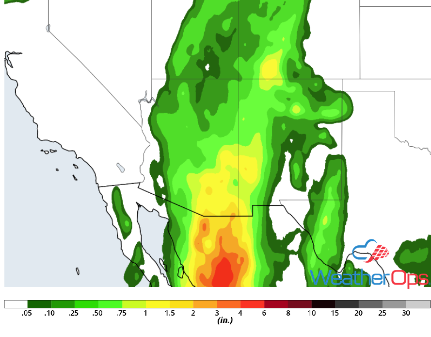 Rainfall Accumulation through Saturday
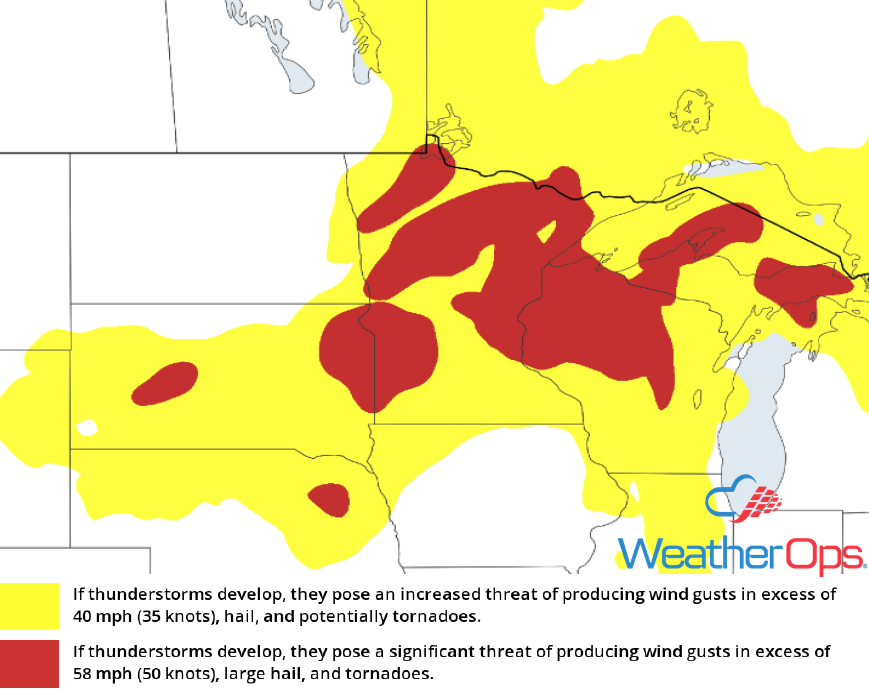
Thunderstorms Saturday for the Upper Midwest into the Northern and Central Plains
Thunderstorms will likely be ongoing across the Upper Midwest Saturday morning. However, by the afternoon hours, strong daytime heating and plentiful moisture will likely allow for new thunderstorm development along a front and/or outflow boundaries left behind from morning storms. Any storms that develop are expected to move northeastward along the front during the afternoon and evening. Large hail, damaging winds, and tornadoes will all be potential hazards with any storms that develop.
Major Cities in Region: Scottsbluff, NE, Bismarck, ND, Pierre, SD, Fargo, ND, Sioux Falls, SD, Minneapolis, MN, Duluth, MN, Wausau, WI
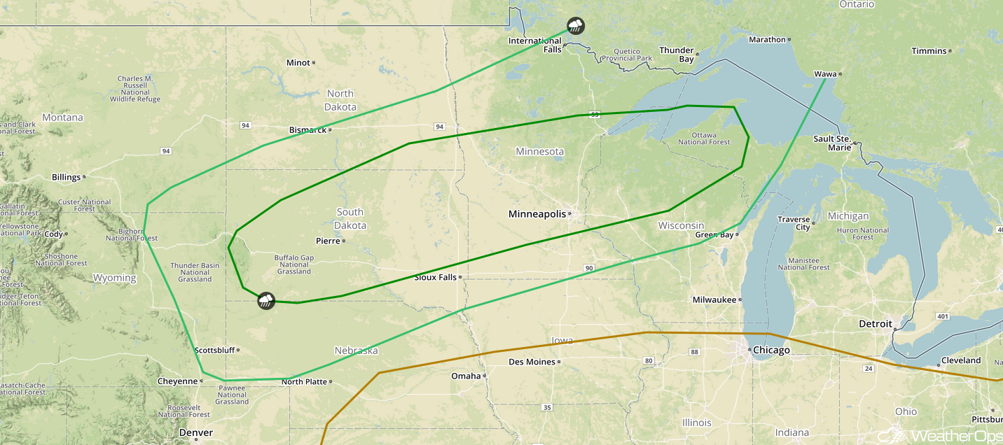 SPC Convective Outlook for Saturday
Excessive Rainfall for the Northern Rockies on Saturday
Moisture moving in from the Northern Plains combined with the remnants of East Pacific tropical storm Bud will bring a risk for heavy rain to the region on Saturday. Because this area has relatively wet soils from previous rainfall, flooding will be a concern. Rainfall totals will range 0.50-1.50 inches with locally higher amounts.
Major Cities in Region: Missoula, MT, Butte, MT, Great Falls, MT, Billings, MT, Glendive, MT
 Rainfall Accumulation for Saturday
Thunderstorm Potential Sunday for the Upper Midwest into the Central and Northern Plains
Another round of thunderstorms is expected across portions of the Upper Midwest, as well as the Northern Plains, on Sunday. Strong daytime heating and plentiful moisture will create a very unstable environment favorable for the development of thunderstorms during the afternoon and early evening. As the sun sets and the low level jet begins to intensify, thunderstorms will begin to congeal into clusters while increasing in coverage. Damaging winds and large hail will be the primary hazards with the stronger storms.
Major Cities in Region: North Platte, NE, Sioux Falls, SD, Omaha, NE, Minneapolis, MN, Green Bay, WI
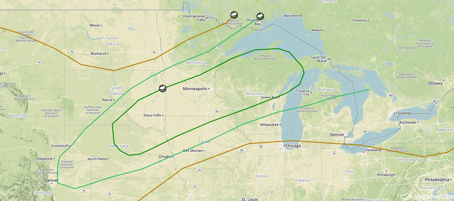 SPC Convective Outlook for Sunday
A Look Ahead
Tropical moisture moving into South Texas and western Louisiana will pose a risk for excessive rainfall beginning Monday and continuing through Wednesday. Current model guidance indicates the potential for 3-6 inches of rain with locally higher amounts in excess of 7 inches; flooding will be likely. Elsewhere, thunderstorms are forecast from the Great Lakes into the Central Plains on Monday ahead of a cold front. On Tuesday, thunderstorms will extend from the Plains into the Ohio Valley. Additional activity may develop across these regions on Wednesday. Thunderstorms are possible across the Southern Plains into South Texas on Thursday.
This is just a brief look at current weather hazards. We can provide you site-specific weather forecast information for the purpose of protecting your personnel and assets and to assess your weather risk. Try a 7-day demo right away and learn how timely precision weather information can enhance your bottom line.
