


by David Moran, on Jun 1, 2018 11:21:11 AM
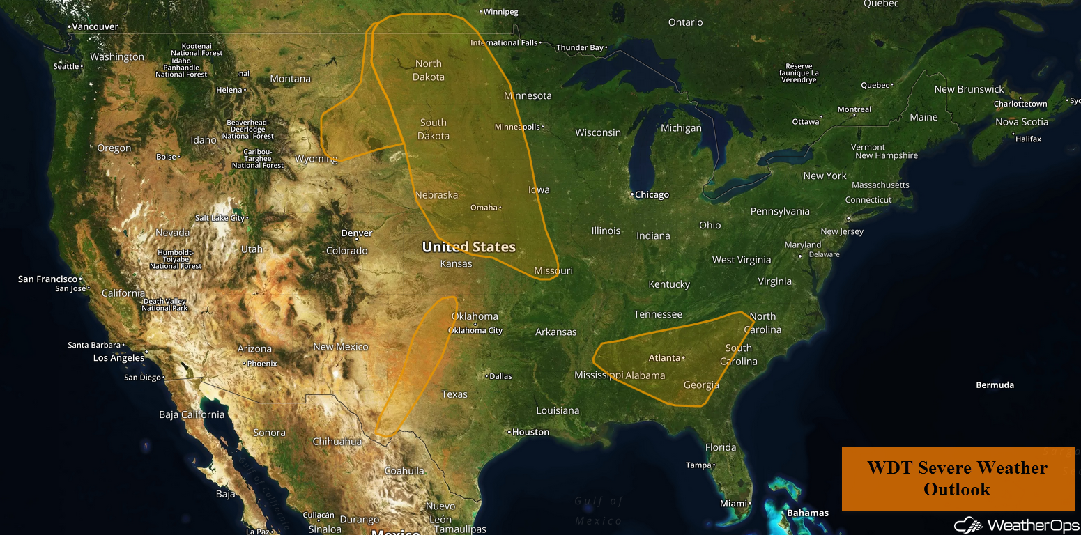
Thunderstorms are forecast to develop across the Northern and Central Plains on Friday ahead of a cold front. These thunderstorms will also pose a risk for excessive rainfall. Across west Texas and western Oklahoma, thunderstorms will likely develop ahead of a dry line. Daytime heating will allow for the development of thunderstorms across northern portions of Alabama and Georgia, as well as western portions of the Carolinas. Thunderstorms across the Mid Atlantic will pose a flooding risk across the region.
- Thunderstorms across the Northern and Central Plains on Friday
- Excessive Rainfall Friday for the Northern and Central Plains
- Risk for Thunderstorms across West Texas and Western Oklahoma Friday
- Thunderstorm Potential Friday across Northern Alabama and Georgia, as well as the Western Portions of the Carolinas
- Excessive Rainfall across the Ohio Valley and Mid Atlantic Friday
- Thunderstorms Saturday from the Central and Southern Plains into the Mid Mississippi Valley
- Risk for Excessive Rainfall across the Upper Midwest on Saturday
- Excessive Rainfall Saturday for the Midwest
- Potential for Excessive Rainfall across the Mid Atlantic on Saturday
- Thunderstorms Sunday across New Mexico and Texas
- Risk for Thunderstorms across the Southeast on Sunday
 US Hazards

Thunderstorms across the Northern and Central Plains on Friday
Daytime heating and ample moisture across the region will allow instability to build through the early afternoon. Scattered thunderstorms will likely develop along a cold front by the late afternoon and into the evening. Storms will rapidly intensify with large hail, damaging winds, and tornadoes all potential hazards. Into the evening, storms will form clusters with damaging winds becoming the primary hazard.
Major Cities in Region: Minot, ND, Bismarck, ND, Pierre, SD, Sioux Falls, SD, Omaha, NE, Kansas City, MO
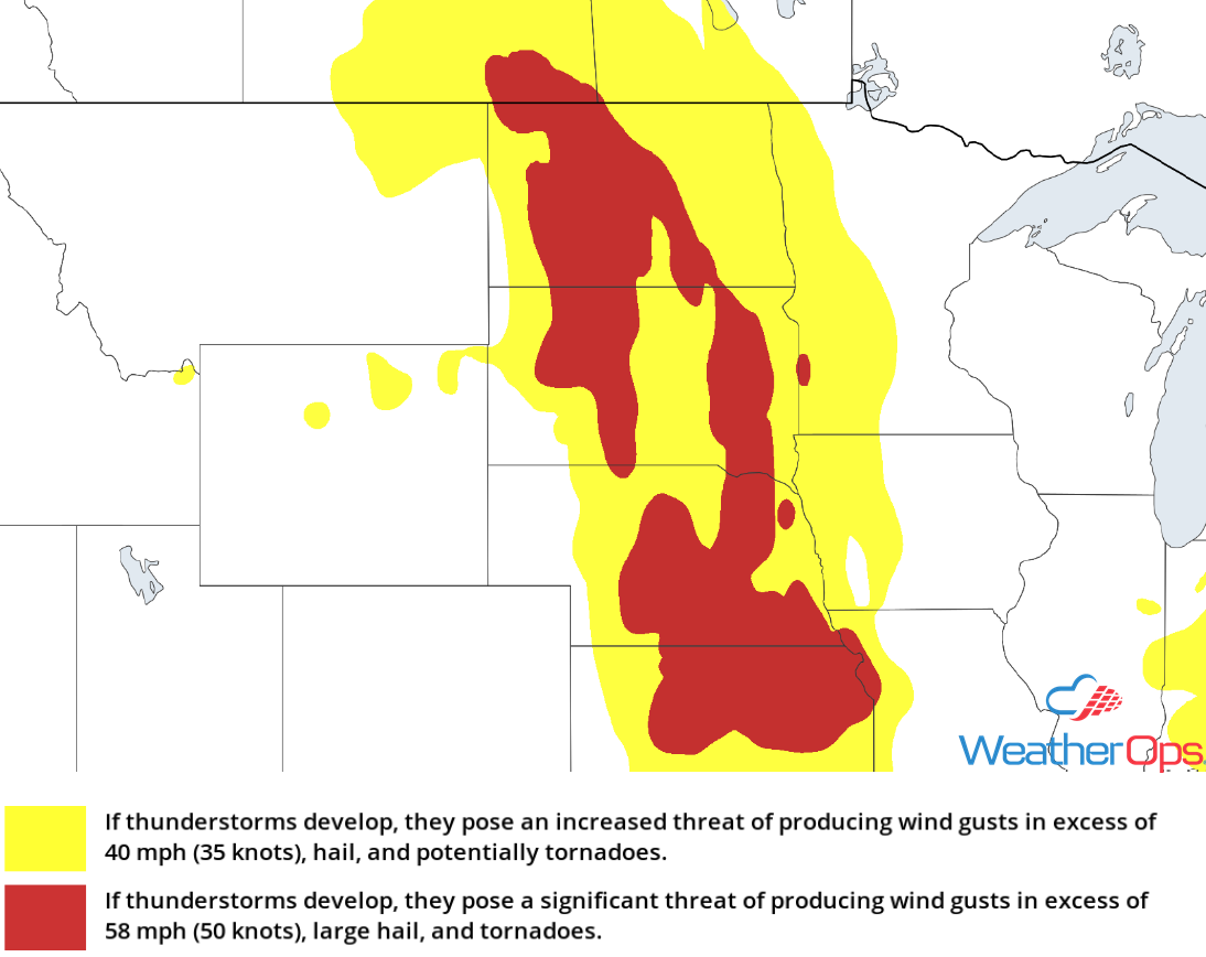 Thunderstorm Risk for Friday
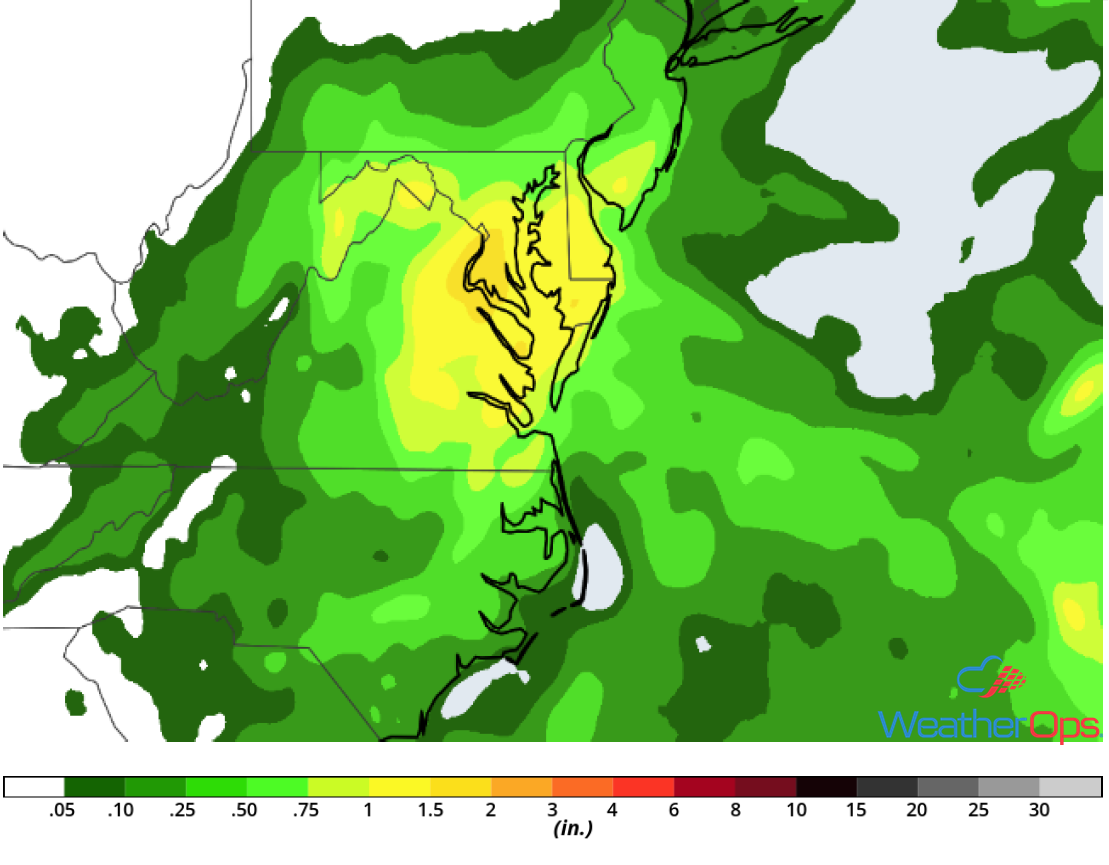
Excessive Rainfall Friday for the Northern and Central Plains
Abundant moisture combined with a slow moving area of low pressure will allow for the development of several lines of thunderstorms that will track across the region. Some of these storms could produce heavy rainfall. Widespread rainfall amounts of 1-2 inches are forecast, with locally heavier amounts in excess of 4 inches. This will allow for a risk of flash flooding.
Major Cities in Region: Minot, ND, Bismarck, ND, Pierre, SD, Sioux Falls, SD, Omaha, NE
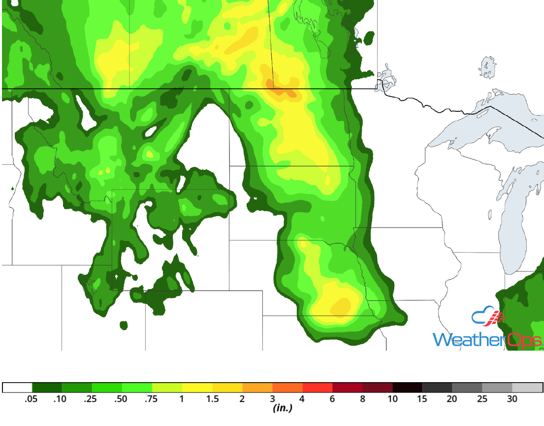 Rainfall Accumulation for Friday
Risk for Thunderstorms across West Texas and Western Oklahoma Friday
Warm temperatures and plentiful moisture will destabilize the atmosphere ahead of a dryline by the early afternoon. As a result, isolated to scattered thunderstorms will likely develop ahead of the dryline, These thunderstorms will intensify rapidly with gusty winds and large hail the primary hazards. Storms should weaken after sunset.
Major Cities in Region: Odessa, TX, Midland, TX, Lubbock, TX, Elk City, OK
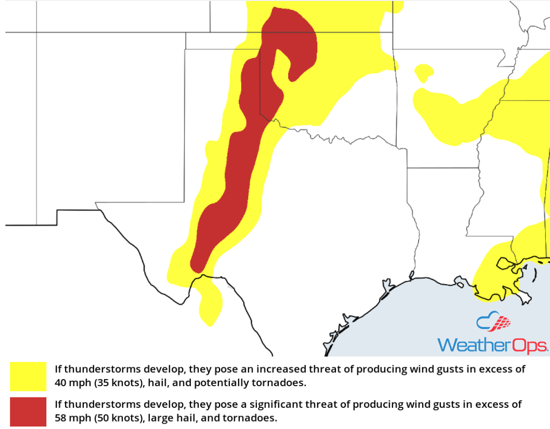 Thunderstorm Risk for Friday
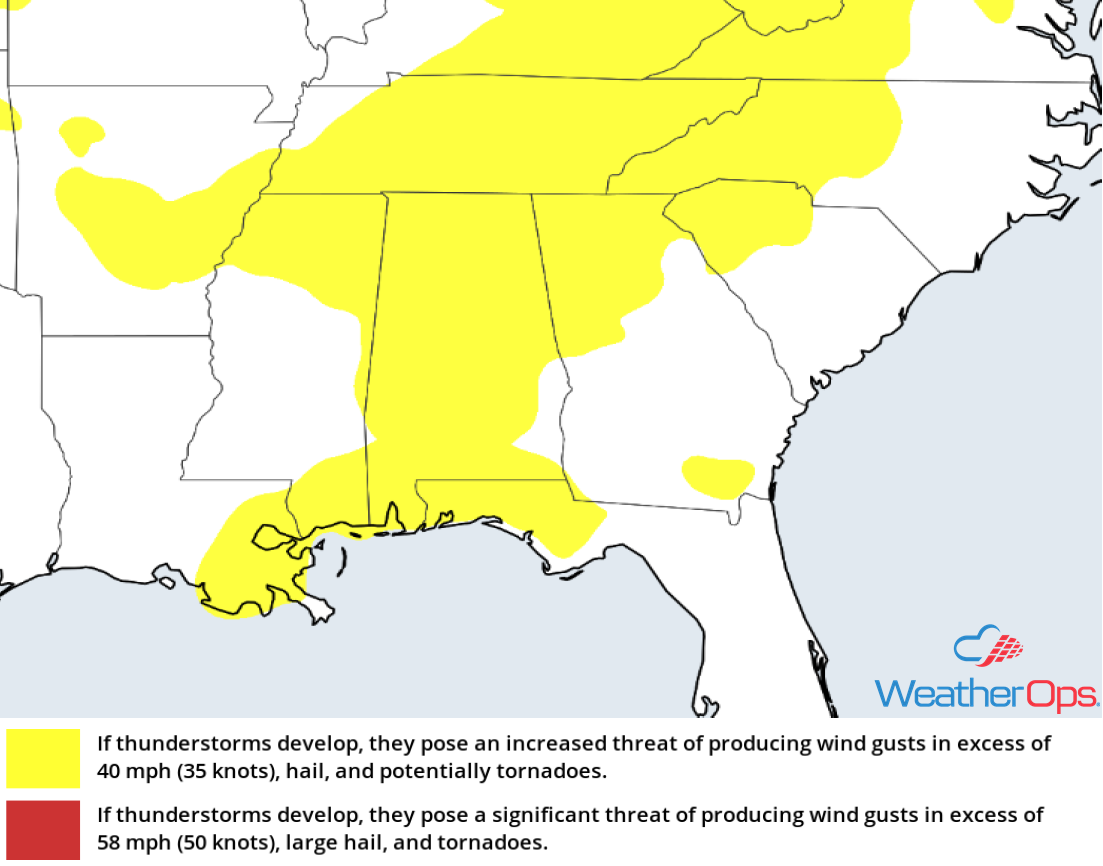
Thunderstorm Potential Friday across Northern Alabama and Georgia, as well as the Western Portions of the Carolinas
Thunderstorms will continue to move across the region but should weaken by early afternoon. In the meantime, daytime heating and plentiful moisture will allow instability to increase. Redevelopment of thunderstorms is expected along the higher terrain by the late afternoon to early evening. Storms will likely be clustered and intensify quickly. Severe winds will be the primary hazards with these storms, but large hail cannot be ruled out. These storms will move out of the area by the overnight hours.
Major Cities in Region: Birmingham, AL, Chattanooga, TN, Atlanta, GA, Spartanburg, SC, Charlotte, NC
 Thunderstorm Risk for Friday
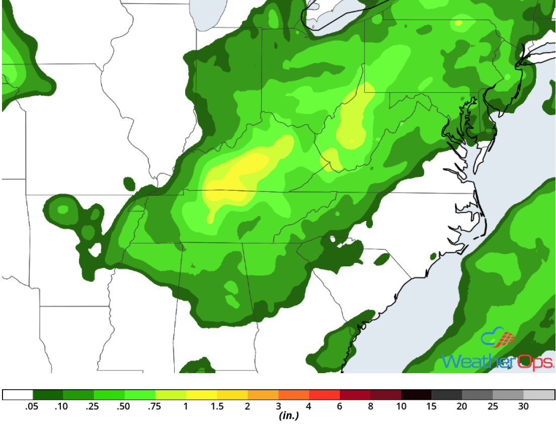
Excessive Rainfall across the Ohio Valley and Mid Atlantic Friday
Scattered showers and thunderstorms will bring moderate to heavy rainfall to the region. These storms will move slowly and over the same areas repeatedly. Although rainfall amounts are not expected to be significant, saturated soil from previous rain will pose a flooding risk across the region. Widespread rainfall amounts of 1-2 inches with locally higher amounts in excess of 3 inches are expected.
Major Cities in Region: Charleston, WV, Washington, DC, Baltimore, MD
 Rainfall Accumulation for Friday
Daytime heating and sufficient moisture across the region will allow instability to build across the region. An area of low pressure will move to the east with the associated cold front being the focus for thunderstorm development. Storms will likely develop during the late afternoon and evening with severe winds and large hail the primary hazards. However, an isolated tornado or two cannot be ruled out. Later in the evening, storms will become linear. The primary hazard will then become damaging winds.
Major Cities in Region: Fort Smith, AR, Little Rock, AR, Springfield, MO, St. Louis, MO, Des Moines, IA
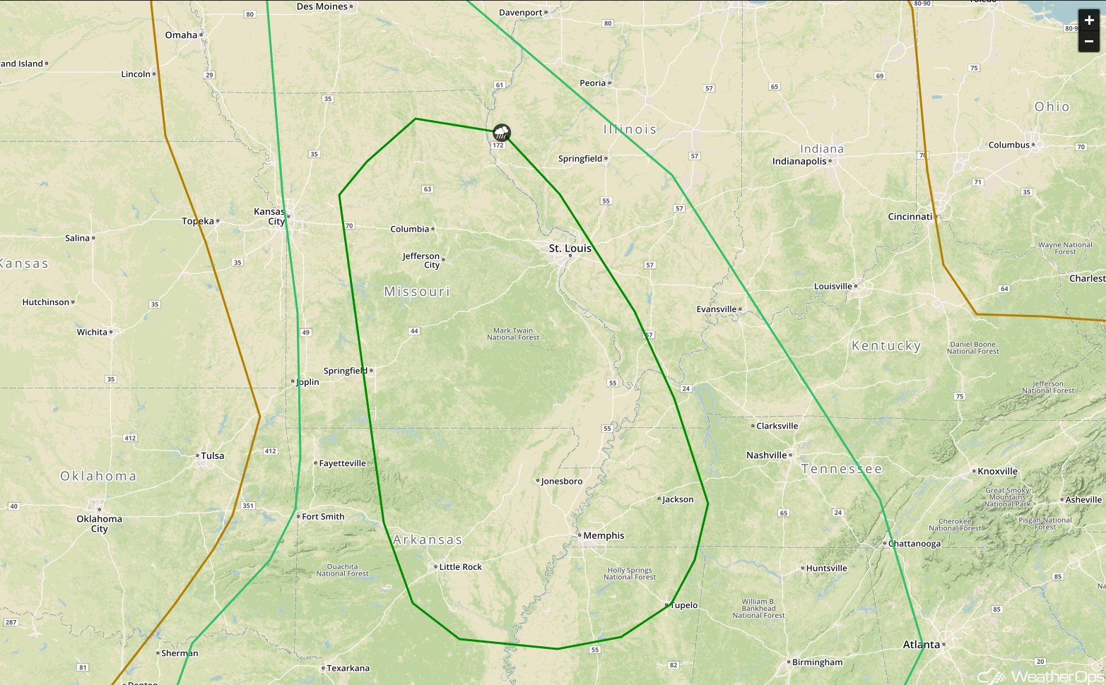 SPC Convective Outlook for Saturday
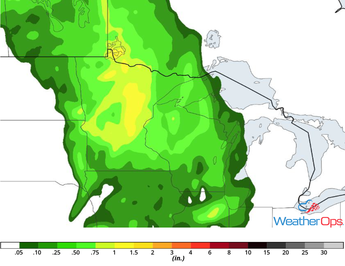
Risk for Excessive Rainfall across the Upper Midwest on Saturday
Showers and thunderstorms will likely develop across the region ahead of a cold front. Widespread moderate to heavy rain is possible within these storms. This activity is expected to move through quickly with rainfall amounts ranging 0.50-1.00 inch and locally higher amounts in excess of 2 inches. As a result, there will be the potential for localized flooding.
Major Cities in Region: Minneapolis, MN, Duluth, MN
 Rainfall Accumulation for Saturday
Excessive Rainfall Saturday for the Midwest
A line of thunderstorms will move across the region on Saturday. Although these storms should track eastward quickly, moderate to heavy rainfall is likely. Widespread amounts between 0.50-1.00 inch are expected with locally higher amounts in excess of 2 inches. This will pose a risk for localized flooding.
Major Cities in Region: Kansas City, MO, Columbia, MO
 Rainfall Accumulation for Saturday
Potential for Excessive Rainfall across the Mid Atlantic on Saturday
Scattered slow-moving thunderstorms are expected to develop in association with an area of low pressure moving over the area. Moisture across the area will allow for moderate to heavy rainfall. These storms are expected to train. Rainfall amounts will range 1-2 inches with locally higher amounts. Given the already saturated ground, there will be a risk for flooding and flash flooding,
Major Cities in Region: Washington, DC, Baltimore, MD
 Rainfall Accumulation for Saturday
Thunderstorms Sunday across New Mexico and Texas
Thunderstorms will develop as instability builds into the early afternoon on Sunday. Gusty winds and large hail will be the primary hazards with these storms. Activity will weaken after dark with the loss of daytime heating.
Major Cities in Region: El Paso, TX, Albuquerque, NM, Santa Fe, NM
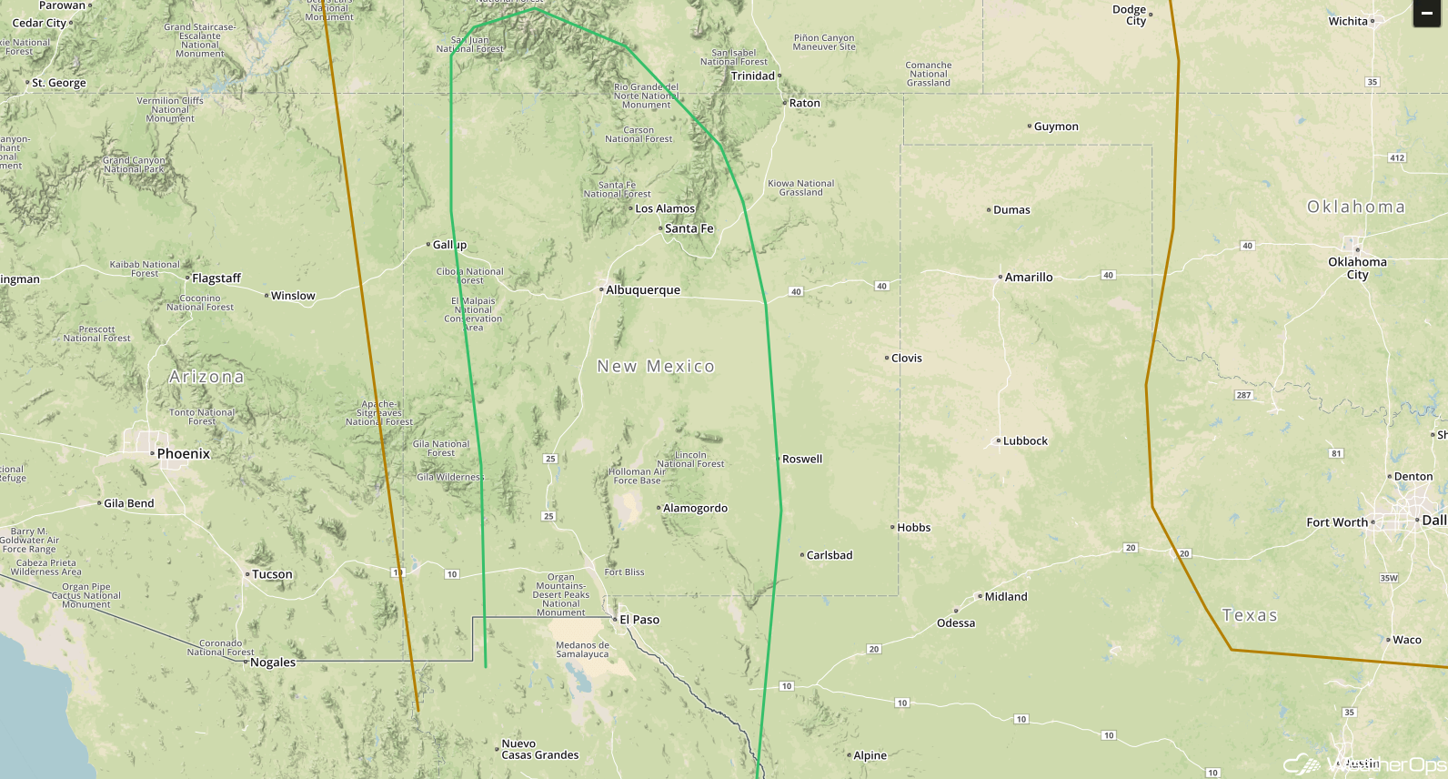 SPC Convective Outlook for Sunday
Risk for Thunderstorms across the Southeast on Sunday
As daytime heating and moisture increase across the region on Sunday, thunderstorms are forecast to develop ahead of a cold front. Storms will be scattered, but storms that develop during the late afternoon and early evening could produce damaging winds and small hail. These storms will move to the south and east as the evening progresses and weaken shortly after sunset.
Major Cities in Region: Mobile, AL, Montgomery, AL, Columbus. GA, Atlanta, GA, Tallahassee, FL
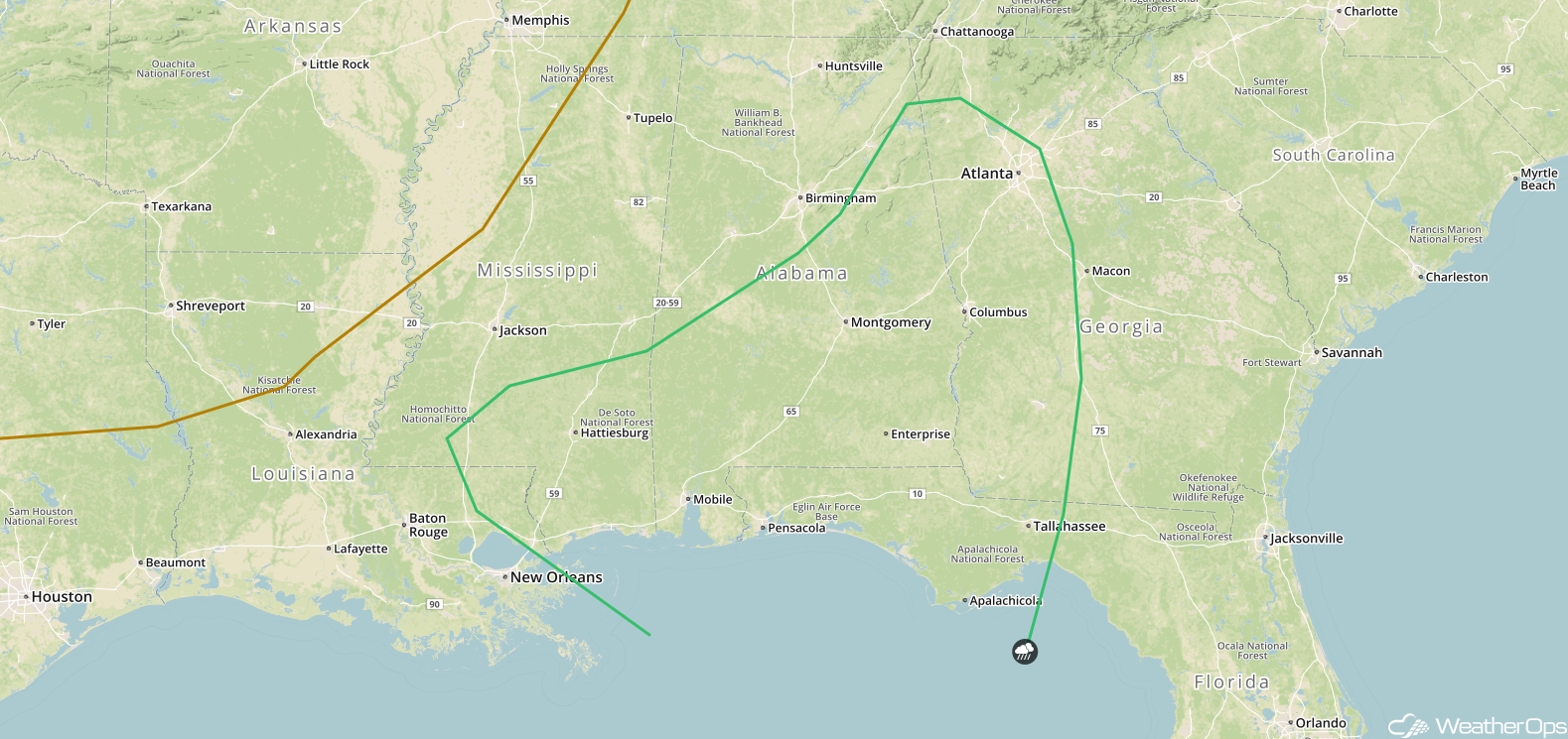 SPC Convective Outlook for Sunday
A Look Ahead
Showers and thunderstorms will move into the Northeast on Monday as an area of low pressure moves through eastern Canada and the associated cold front moves through the Great Lakes and Northeast. On Tuesday, moderate to heavy rain may occur along the New England coast as a low moves northward. By Wednesday, showers and thunderstorms may develop across the Northern Plains as a weak system moves eastward.
This is just a brief look at current weather hazards. We can provide you site-specific weather forecast information for the purpose of protecting your personnel and assets and to assess your weather risk. Try a 7-day demo right away and learn how timely precision weather information can enhance your bottom line.
