National Weather Summary for Friday, July 7, 2017
by David Moran, on Jul 7, 2017 10:29:16 AM
Scattered thunderstorms are forecast to develop on Friday across portions of the Eastern Great Lakes, Ohio Valley, and Northeast ahead of a cold front. Across portions of the High and Central Plains, thunderstorms are forecast during Friday afternoon and evening. Excessive rainfall is likely across portions of the Northeast along a stalled front.
- Thunderstorms Friday across the Central Plains, Eastern Great Lakes, Ohio Valley, and Northeast
- Risk for Thunderstorms across the Carolinas Friday
- Excessive Rainfall Friday for Portions of the Northeast
- Thunderstorm Potential for the Southern Plains, Southeast, and Mid Atlantic on Saturday
- Strong to Severe Thunderstorms Possible Saturday across the Northeast
- Thunderstorms across the Northern Plains and Upper Midwest on Sunday
- Potential for Thunderstorms Sunday across the Mid Atlantic
- Tropical Update
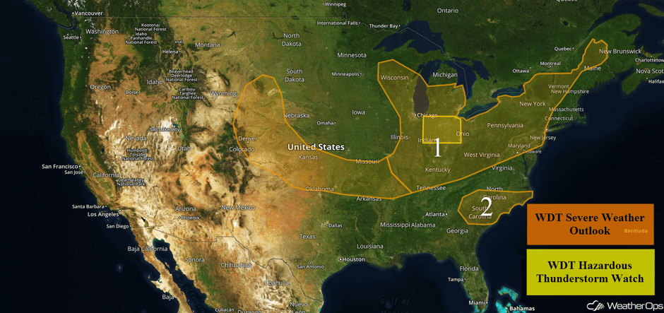 US Hazards
Thunderstorms Friday across the Central Plains, Eastern Great Lakes, Ohio Valley, and Northeast
A cold front dropping southward across the Central Plains and Ozarks as well as weak upper level disturbances moving through the High Plains will allow for the development of isolated to scattered thunderstorms this afternoon and evening. Daytime heating will lead to increasing instability and allow for a potential for strong to severe thunderstorms capable of gusty winds and hail.
Further east, an upper level system will impact a large region including portions of the Great Lakes, Ohio Valley, and Northeast. At the surface, a cold front sliding southeastward will provide a focus for thunderstorm development, and storms will be favorable for the development of strong to severe thunderstorms. Thunderstorms are currently ongoing across portions of Indiana and Ohio, with more development likely later today. Large hail, damaging winds, and tornadoes will all be potential hazards with these storms. The highest risk will be centered over Indiana, Kentucky, and Ohio where storms may be enhanced by outflow boundaries from earlier convection.
Update 12:08pm EDT: Tornado Warning west of Mansfield, OH.
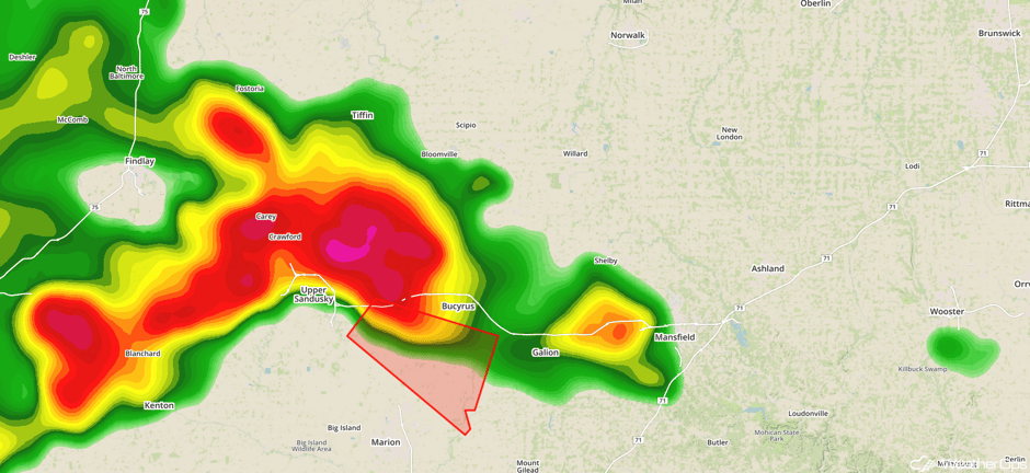 Radar 12:08pm EDT
Update 11:58am CDT: Severe thunderstorms capable of hail and damaging winds southeast of Chicago.
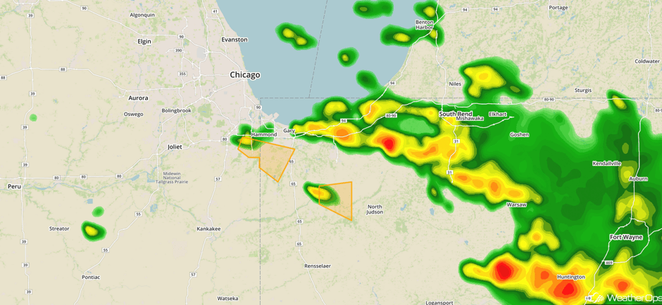 Radar 11:58am CDT
Update 12:26pm CDT: Tornado Warning in north central Indiana.
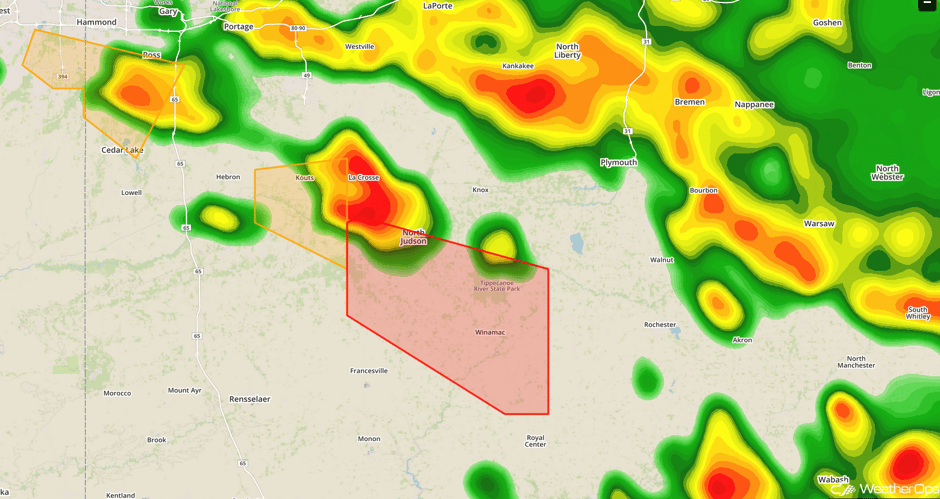 Radar 12:26pm CDT
Update 1:39pm EDT: Severe thunderstorm capable of hail and damaging winds approaching Plattsburgh, NY.
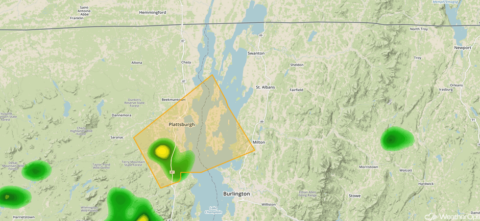 Radar 1:39pm EDT
Update 1:45pm EDT: Severe Thunderstorm Watch in effect for portions of Illinois, Indiana, Ohio, Pennsylvania, and West Virginia until 9pm EDT.
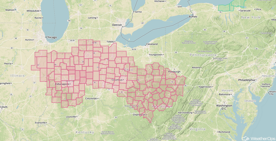 Severe Thunderstorm Watch
Update 2:32pm EDT: Line of thunderstorms approaching SE Ohio. Hail and damaging winds will be the primary hazards.
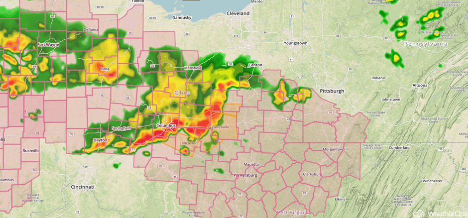 Radar 2:32pm EDT
Major Cities in Region: Denver, CO, Cheyenne, WY, North Platte, NE, Wichita, KS, Tulsa, OK, St. Louis, MO, Memphis, TN, Chicago, IL, Indianapolis, IN, Nashville, TN, Cleveland, OH, Washington, DC, Albany, NY, Burlington, VT, Caribou, ME
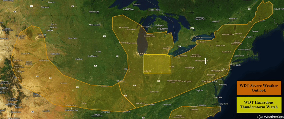 Region 1
Risk for Thunderstorms across the Carolinas Friday
Isolated thunderstorm development is anticipated later this afternoon and evening as a weak cold front moves into the region. Storms will be strong to severe with gusty winds the primary hazard.
Update 2:15pm EDT: Severe thunderstorm capable of hail and damaging winds in Upstate South Carolina.
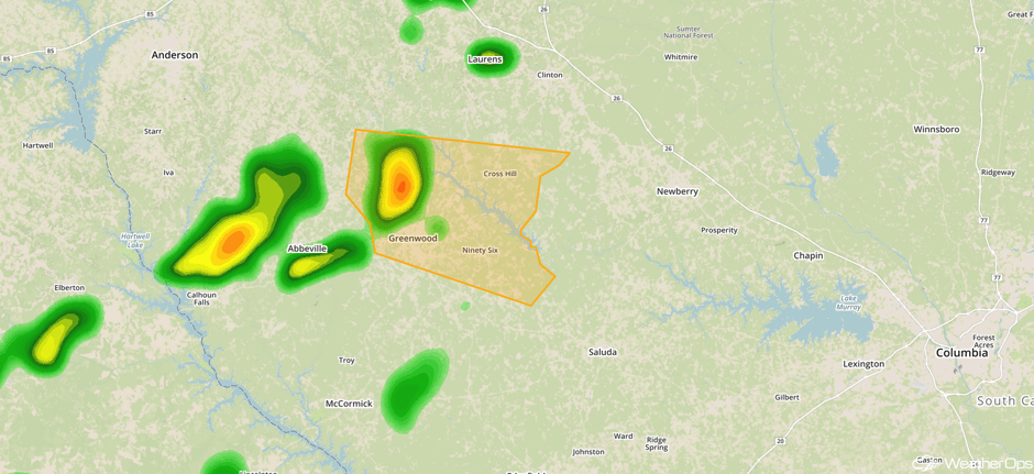 Radar 2:15pm EDT
Major Cities in Region: Greenville, SC, Augusta, GA, Charlotte, NC, Columbia, SC, Wilmington, NC
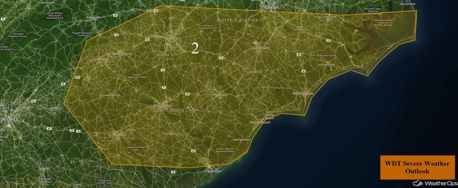 Region 2
Excessive Rainfall Friday for Portions of the Northeast
There will be a risk for excessive rainfall across portions of New England on Friday along a stalled front. Rainfall totals will range 0.50-1.50 inches with locally higher amounts in excess of 1.50 inches.
Major Cities in Region: New York, NY, Bridgeport, CT, Providence, RI
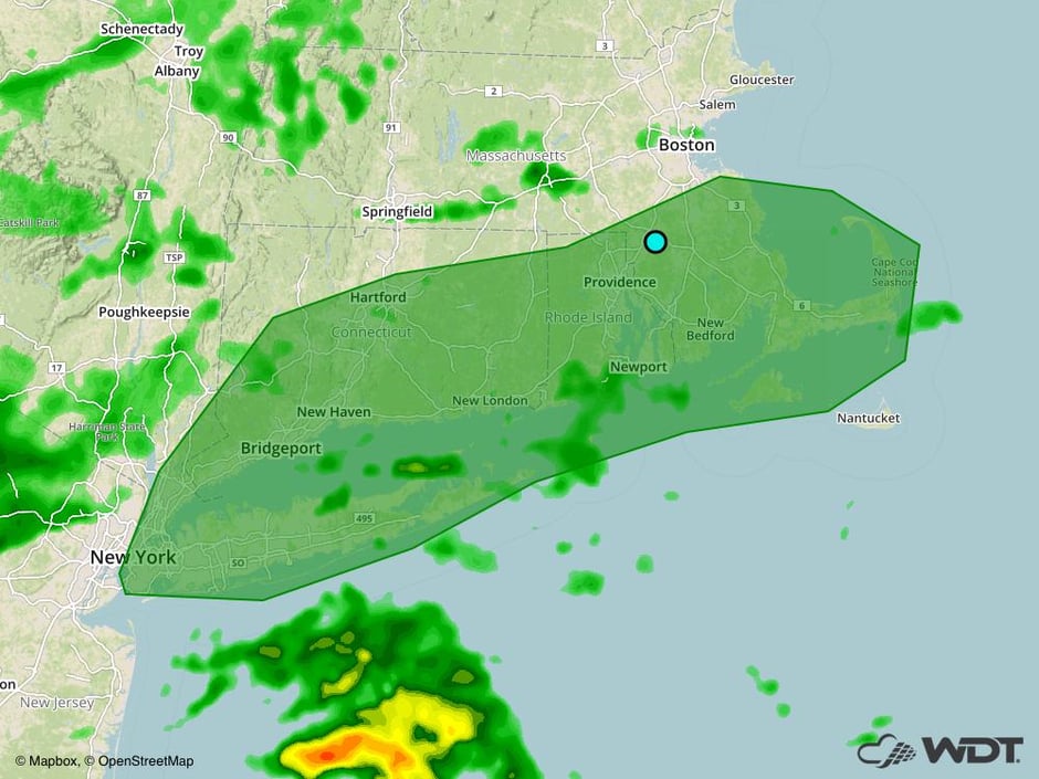 Excessive Rainfall Risk Outline for Friday
Thunderstorm Potential for the Southern Plains, Southeast, and Mid Atlantic on Saturday
High pressure will continue to move eastward on Saturday. However, at the surface, a cold front will continue to move slowly eastward with the tail end of the front stalling across the Mid Atlantic, Southeast, and southern Plains. Showers and thunderstorms, some severe, may develop. Significant severe weather is unlikely, but severe winds and large hail will be the primary hazards within the stronger storms. Further west, in the Central Plains, moisture and daytime heating may allow for the development of thunderstorms. Strong to severe wind gusts will be the primary hazards with these storms.
Major Cities in Region: Amarillo, TX, North Platte, NE, Dodge City, KS, Oklahoma City, OK, Shreveport, LA, Jackson, MS, Birmingham, AL, Atlanta, GA, Raleigh, NC
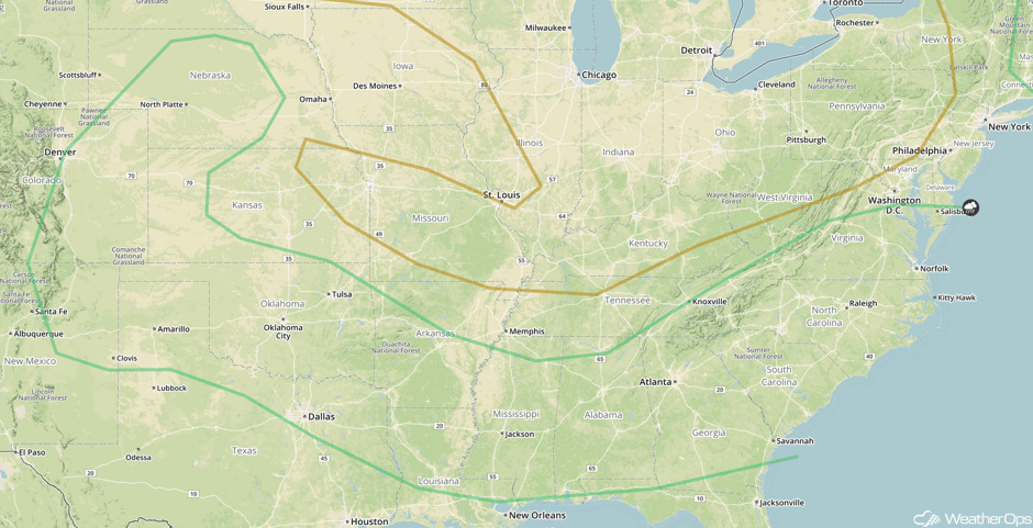 SPC Convective Outlook for Saturday
Strong to Severe Thunderstorms Possible Saturday across the Northeast
The northern end of the surface cold front will move eastward over the Northeast. Moderate instability is expected to build just ahead of the front, which will likely allow for the development of strong to severe thunderstorms during the afternoon and evening hours. Strong to severe wind gusts and some isolated large hail will be the primary hazards.
Major Cities in Region: Providence, RI, Boston, MA, Augusta, ME, Bangor, ME
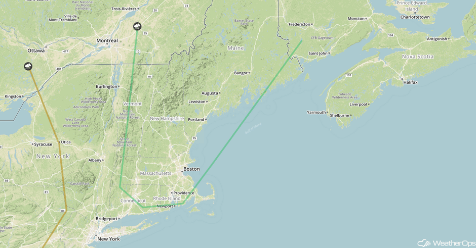 SPC Convective Outlook for Saturday
Thunderstorms across the Northern Plains and Upper Midwest on Sunday
A weak area of low pressure and associated warm front stretching from the Northern Plains into western Wisconsin will develop over the Northern Plains and Upper Midwest on Sunday. Southerly winds will pull warm, moist air into the region, allowing instability to build. Strong to severe thunderstorms will likely develop during the late afternoon into the evening and spread southeastward as complexes. Severe winds will be the primary hazard, but there could be some isolated instances of hail.
Major Cities in Region: Sioux Falls, SD, Des Moines, IA, Minneapolis, MN, Madison, WI
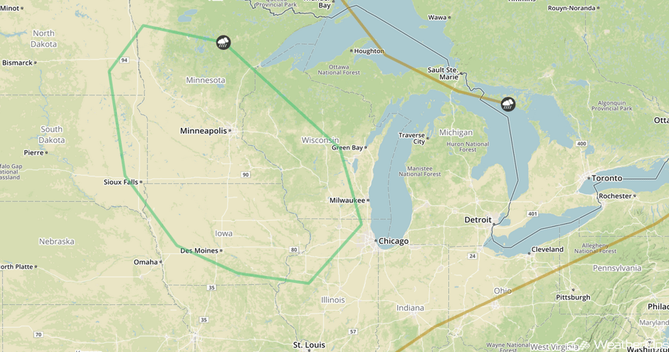 SPC Convective Outlook for Sunday
Potential for Thunderstorms Sunday across the Mid Atlantic
A lingering front will be the focus for thunderstorms across portions of the Mid Atlantic on Sunday. While the severe potential is low, severe winds will be the primary hazard with any storms that develop.
Major Cities in Region: Savannah, GA, Charleston, SC, Myrtle Beach, SC, Wilmington, NC
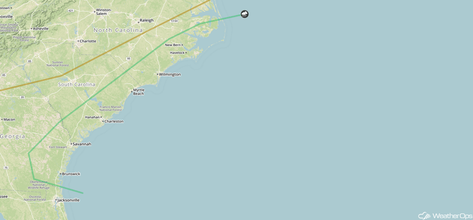 SPC Convective Outlook for Sunday
Tropical Update
The center of Tropical Depression Four is located 690 miles east of the Lesser Antilles and is moving toward the west-northwest near 21 mph. Maximum sustained winds are near 30 mph. This depression is expected to become a remnant low later tonight.
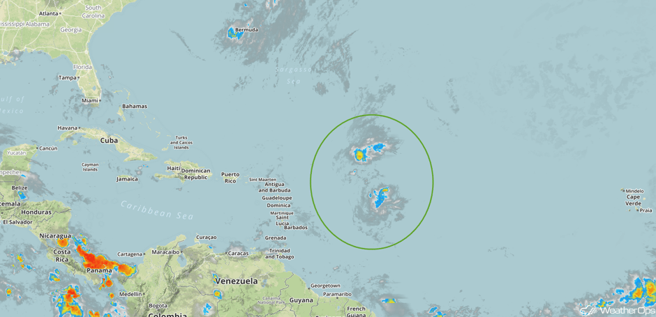 Enhanced Infrared Tropical Satellite
A Look Ahead
An area of low pressure over the Northern Plains will bring scattered showers and thunderstorms to the Upper Midwest and Great Lakes on Monday. This activity will move into the Great Lakes and Ohio Valley on Tuesday and continue through Thursday.
This is just a brief look at current weather hazards. We can provide you site-specific weather forecast information for the purpose of protecting your personnel and assets and to assess your weather risk. Try a 7-day demo right away and learn how timely precision weather information can enhance your bottom line.


