National Weather Summary for Friday, July 28, 2017
by David Moran, on Jul 28, 2017 11:03:26 AM
Strong to severe thunderstorms and excessive rainfall are forecast Friday from the Tennessee and Ohio Valleys to the East Coast. Thunderstorms may develop across the High Plains along a frontal boundary. Monsoonal moisture will allow for a risk of excessive rainfall from the Southwest to the Central High Plains.
- Thunderstorm and Excessive Rainfall Potential from the Tennessee and Ohio Valleys to the East Coast Friday
- Risk for Thunderstorms Friday across the High Plains
- Excessive Rainfall for the Southwest into the Central High Plains on Friday
- Thunderstorms Saturday for the Southeast
- Potential for Thunderstorms across the Front Range and High Plains on Saturday
- Excessive Rainfall Continues Saturday for the Southwest
- Potential for Excessive Rainfall across the Front Range and High Plains on Sunday
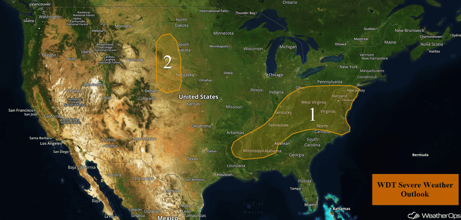 US Hazards
Thunderstorm and Excessive Rainfall Potential from the Tennessee and Ohio Valleys to the East Coast Friday
An intensifying area of low pressure is forecast to track eastward from the Ohio Valley to the Mid Atlantic today and tonight. This will cause widespread showers and thunderstorms across much of the region, bringing a somewhat elevated risk for excessive rainfall along with a marginal threat for strong to severe thunderstorms. Rainfall amounts will average 1-3 inches with locally higher amounts in excess of 4 inches. This may lead to an increased risk for flooding. Some thunderstorms may have the potential to produce gusty winds, but the overall severe risk will be somewhat mitigated due to widespread storm coverage and associated cloud cover.
Update 1:51pm EDT: Severe thunderstorm capable of hail and damaging winds in northeastern North Carolina.
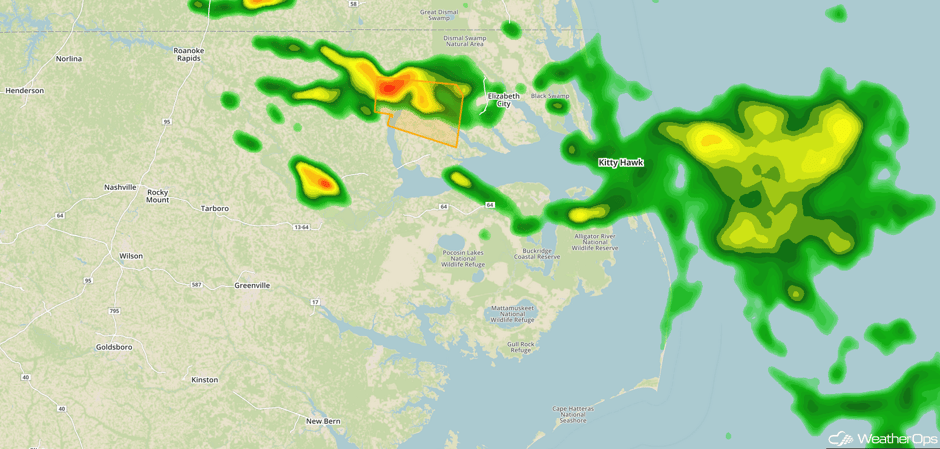 Radar 1:51pm EDT
Update 2:10pm EDT: Thunderstorms capable of hail and damaging winds in upstate South Carolina.
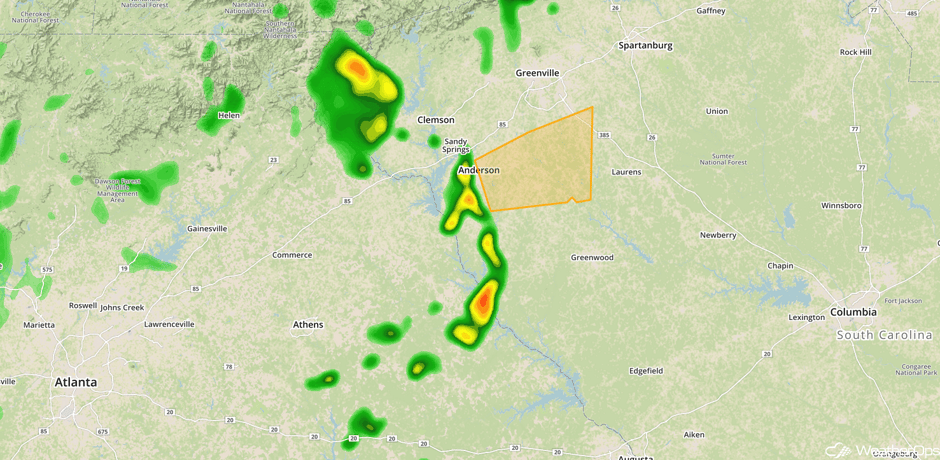 Radar 2:10pm EDT
Update 2:27pm EDT: Rain rates approaching 1.5"/hr near Washington, D.C.
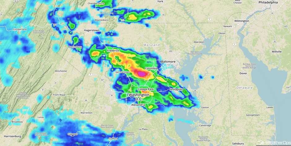 One Hour Rain Rates
Update 2:47pm EDT: Tornado Warning SW of Elizabeth City, NC.
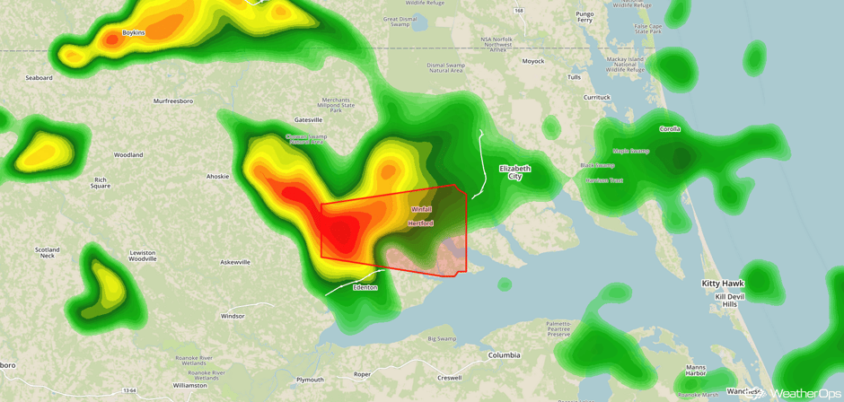 Radar 2:47pm EDT
Major Cities in Region: Memphis, TN, Jackson, MS, Nashville, TN, Knoxville, TN Charleston, WV, Richmond, VA, Washington, DC, Baltimore, MD, Philadelphia, PA
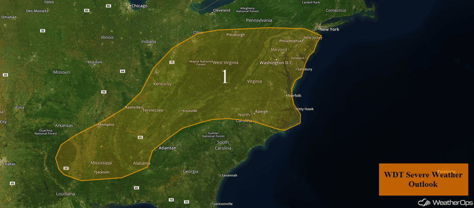 Region 1
Risk for Thunderstorms Friday across the High Plains
A weakening front is expected to move into the central and northern High Plains today. With low level moisture moving northward and building instability, some strong to severe thunderstorms may develop during the afternoon and evening. Gusty winds and hail will be the primary hazards with these storms.
Major Cities in Region: Rapid City, SD, North Platte, NE
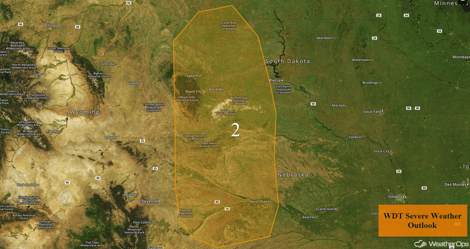 Region 2
Excessive Rainfall for the Southwest into the Central High Plains on Friday
Monsoonal moisture will spread from the Southwest, across the Rockies, and into the central High Plains today. This moisture will interact with a stalled front and generate showers and thunderstorms across the region, with a threat of excessive rainfall expected. General rainfall amounts of 0.50-1.00 inch with locally higher amounts in excess of 1.50 inches are forecast.
Major Cities in Region: Tucson, AZ, Albuquerque, NM, Denver, CO
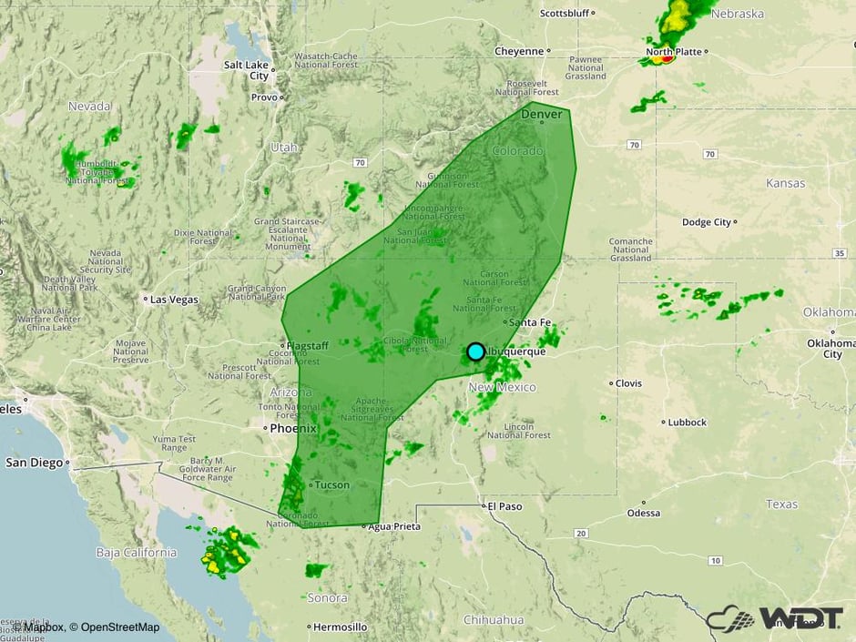 Excessive Rainfall Risk Outline for Friday
Thunderstorms Saturday for the Southeast
A slow moving cold front tracking across portions of the Southeast will produce scattered thunderstorms across the region on Saturday. Some storms will be ongoing during the morning hours, with more robust activity during the afternoon and evening. Thunderstorms that develop will have the potential to produce gusty winds, but the overall severe threat will be low.
Major Cities in Region: Mobile, AL, Tallahassee, FL, Savannah, GA, Charleston, SC, Myrtle Beach, SC, Wilmington, NC
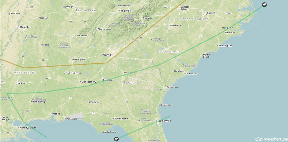 SPC Convective Outlook for Saturday
Potential for Thunderstorms across the Front Range and High Plains on Saturday
A nearly stationary front combined with favorable upslope flow should lead to the development of scattered thunderstorms during the afternoon and evening, perhaps continuing into the overnight hours. Any storms that develop will be capable of gusty winds and hail. In addition, excessive rainfall may also occur with rainfall amounts 0.50-1.50 inches and locally heavier amounts in excess of 2 inches forecast. Given recent heavy rains, there will be an increased risk for flooding.
Major Cities in Region: Colorado Springs, CO
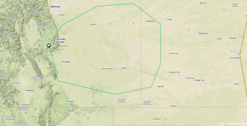 SPC Convective Outlook for Saturday
Excessive Rainfall Continues Saturday for the Southwest
Monsoonal showers and thunderstorms can be expected across portions of southeast Arizona and southwest New Mexico today. Some local areas of excessive rainfall amounts of 0.25-0.50 inch can be expected, with isolated amounts in excess of 0.75 inch.
Major Cities in Region: Tucson, AZ
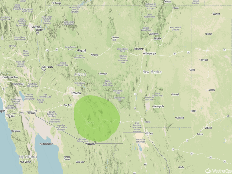 Excessive Rainfall Risk Outline for Saturday
Potential for Excessive Rainfall across the Front Range and High Plains on Sunday
Showers and thunderstorms are forecast to develop once again on Sunday across portions of the Front Range and the adjacent High Plains area. While a strong thunderstorm or two may be possible, the primary risk on Sunday appears to be excessive rainfall. Rainfall amounts of 0.50-1.50 inches with locally heavier amounts in excess of 2 inches are expected. This may allow for a risk for flooding in areas that have received heavy rain in prior days.
Major Cities in Region: Colorado Springs, CO, Amarillo, TX, Dodge City, KS
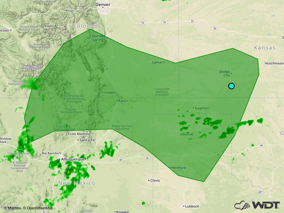 Excessive Rainfall Risk Outline for Sunday
A Look Ahead
Showers and thunderstorms are likely Monday and Tuesday as deep moisture interacts with a stalled frontal boundary. While isolated strong storms will be possible, the primary threat will be excessive rainfall. Two day rainfall amounts could average 2-4 inches with locally higher amounts in excess of 6 inches possible.
This is just a brief look at current weather hazards. We can provide you site-specific weather forecast information for the purpose of protecting your personnel and assets and to assess your weather risk. Try a 7-day demo right away and learn how timely precision weather information can enhance your bottom line.


