


by David Moran, on Jul 13, 2018 11:15:14 AM
Thunderstorms will continue across the Midwest and Central Plains on Friday ahead of a slow moving cold front. In addition to these storms, there will be a potential for excessive rainfall. The risk for excessive rainfall will continue across the Southwest through Saturday as monsoonal moisture remains across the region.
- Thunderstorms for the Midwest and Central Plains on Friday
- Excessive Rainfall Friday for the Midwest and Central Plains
- Risk for Excessive Rainfall for the Southwest through Saturday
- Thunderstorm Potential Saturday for the Northern Plains
- Risk for Thunderstorms across the Northeast on Saturday
- Thunderstorms Sunday across the High Plains
- Potential for Thunderstorms across the Upper Midwest on Sunday
- Thunderstorms Sunday for the Northeast
- Tropical Update
US Hazards
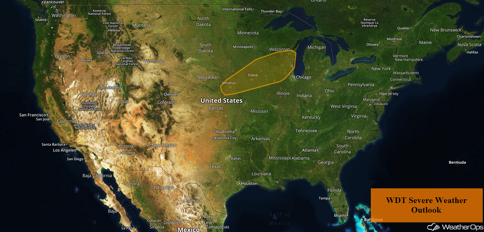
Thunderstorms for the Midwest and Central Plains on Friday
A slow moving cold front is forecast to progress to the east-southeast and south across the Midwest and Central Plains throughout the day today. Thunderstorms will continue during the morning with some becoming strong to severe. Into the afternoon and evening, instability is expected to build as a result of plentiful moisture and daytime heating. This will allow thunderstorms to continue and additional activity to develop. Strong winds and large hail will be the primary hazards with these storms.
Major Cities in Region: Dodge City, KS, Omaha, NE, Des Moines, IA, Minneapolis, MN, Green Bay, WI, Milwaukee, WI
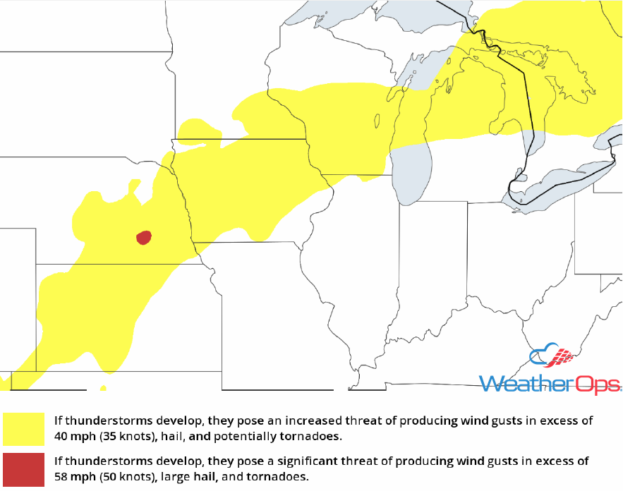
Thunderstorm Risk for Friday
Excessive Rainfall Friday for the Midwest and Central Plains
In addition to the severe weather threat described above, there will be a risk for excessive rain. Rainfall accumulations of 1.50-2.00 inches are forecast with locally higher amounts in excess of 3 inches. This will allow for a risk for flooding and flash flooding.
Major Cities in Region: Sioux Falls, SD, Des Moines, IA
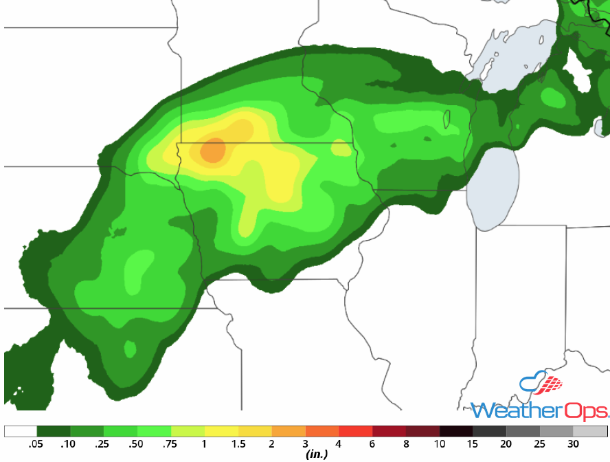
Rainfall Accumulation for Friday
Risk for Excessive Rainfall for the Southwest through Saturday
With monsoonal moisture remaining over the Southwest, moderate to heavy rainfall will continue through Saturday. Rainfall totals will range 1.50-3.00 inches with locally higher amounts in excess of 5 inches. Given rainfall from previous days, there will be a risk for flooding and flash flooding.
Major Cities in Region: Tucson, AZ, Truth or Consequences, NM
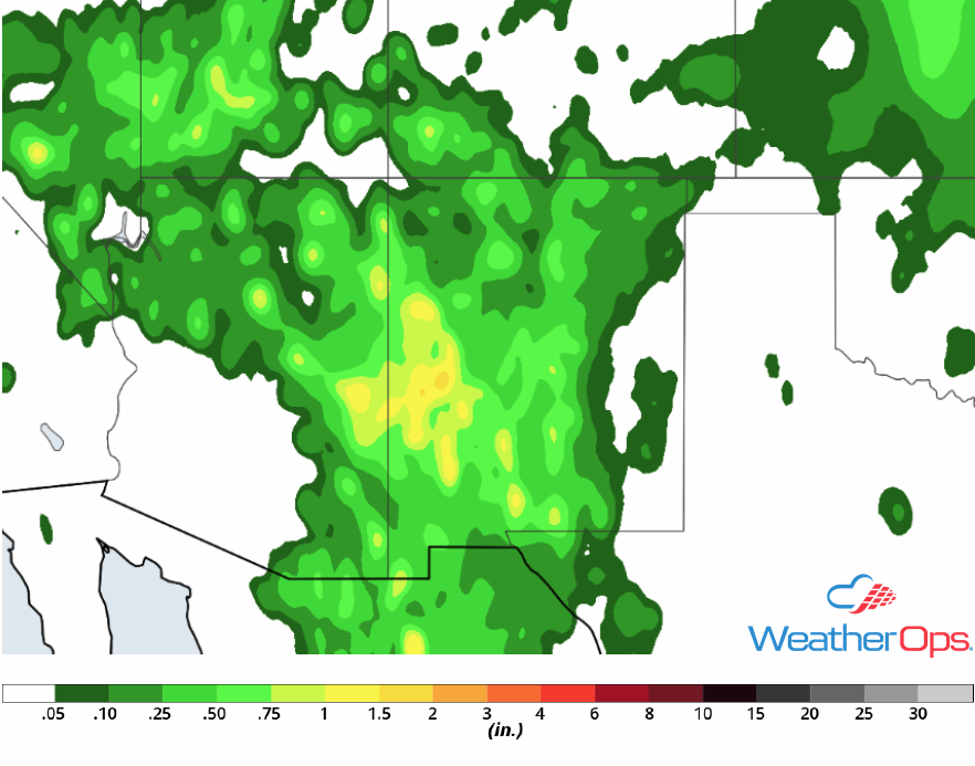
Rainfall Accumulation for Friday
Thunderstorm Potential Saturday for the Northern Plains
An area of low pressure is forecast to develop over Saskatchewan on Saturday with a cold front extending southward into the Northern Plains. As this system moves northeastward, the cold front will push through the region. With plentiful moisture and daytime heating, strong to severe thunderstorms are forecast to develop along and ahead of the front. Strong winds and large hail will be the primary hazards with these storms. An isolated tornado cannot be ruled out.
Major Cities in Region: Minot, ND, Bismarck, ND
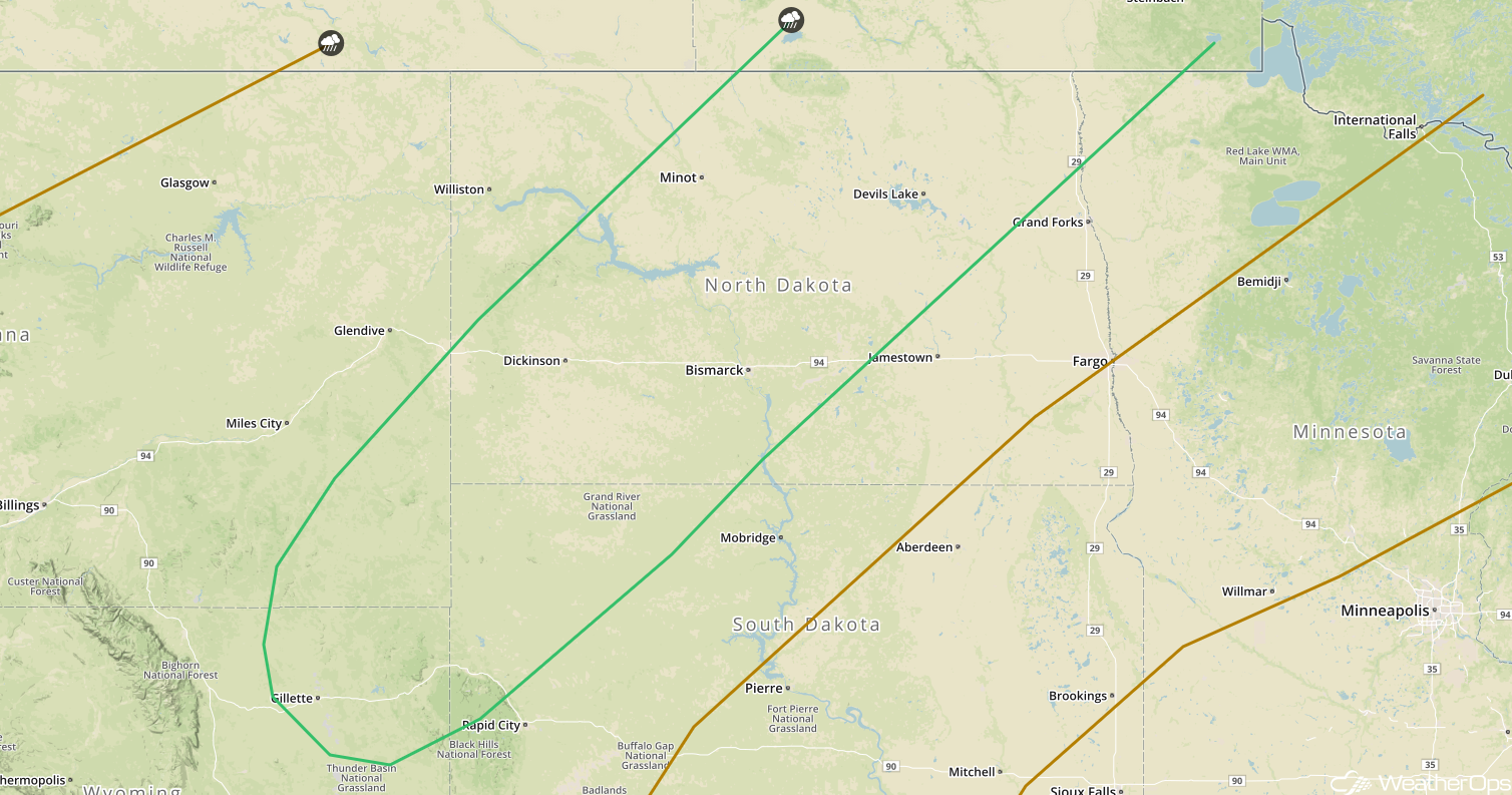
SPC Convective Outlook for Saturday
Risk for Thunderstorms across the Northeast on Saturday
An upper level trough is forecast to move over Ontario on Saturday with a cold front moving across the eastern Great Lakes and Northeast. As temperatures increase and with plentiful moisture in place, instability is forecast to develop ahead of the cold front. This will allow development of strong to severe thunderstorms. Strong wind gusts, hail, frequent lightning, and heavy rain will be potential hazards with these storms.
Major Cities in Region: Buffalo, NY, Syracuse, NY
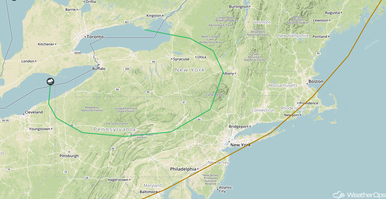
SPC Convective Outlook for Saturday
Thunderstorms Sunday across the High Plains
A weak surface low is forecast to develop over eastern Colorado on Sunday. Due to the location of the low, upslope flow is forecast to develop to the north of the low across the High Plains in northeastern Colorado and southeastern Wyoming. With moisture lifted along the Front Range, strong to severe thunderstorms are forecast to develop over the higher terrain. These thunderstorms will move eastward by late afternoon and evening. Strong winds and large hail will be the primary hazards with these storms.
Major Cities in Region: Denver, CO, Cheyenne, WY, Casper, WY
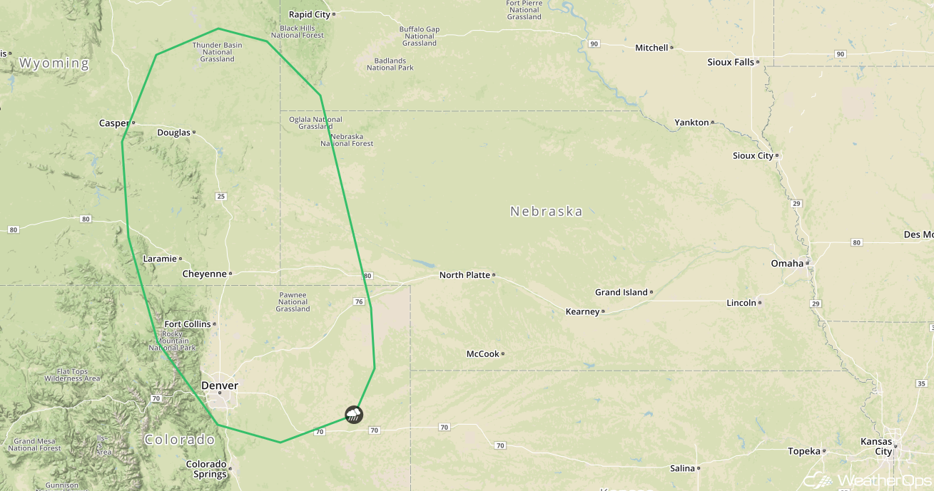
SPC Convective Outlook for Sunday
Potential for Thunderstorms across the Upper Midwest on Sunday
The cold front across the Northern Plains will continue to move eastward on Sunday. As it does, thunderstorms will likely develop across the Upper Midwest during the afternoon and evening ahead of the front. Strong winds and large hail will be the primary hazards with these storms.
Major Cities in Region: Minneapolis, MN, Duluth, MN
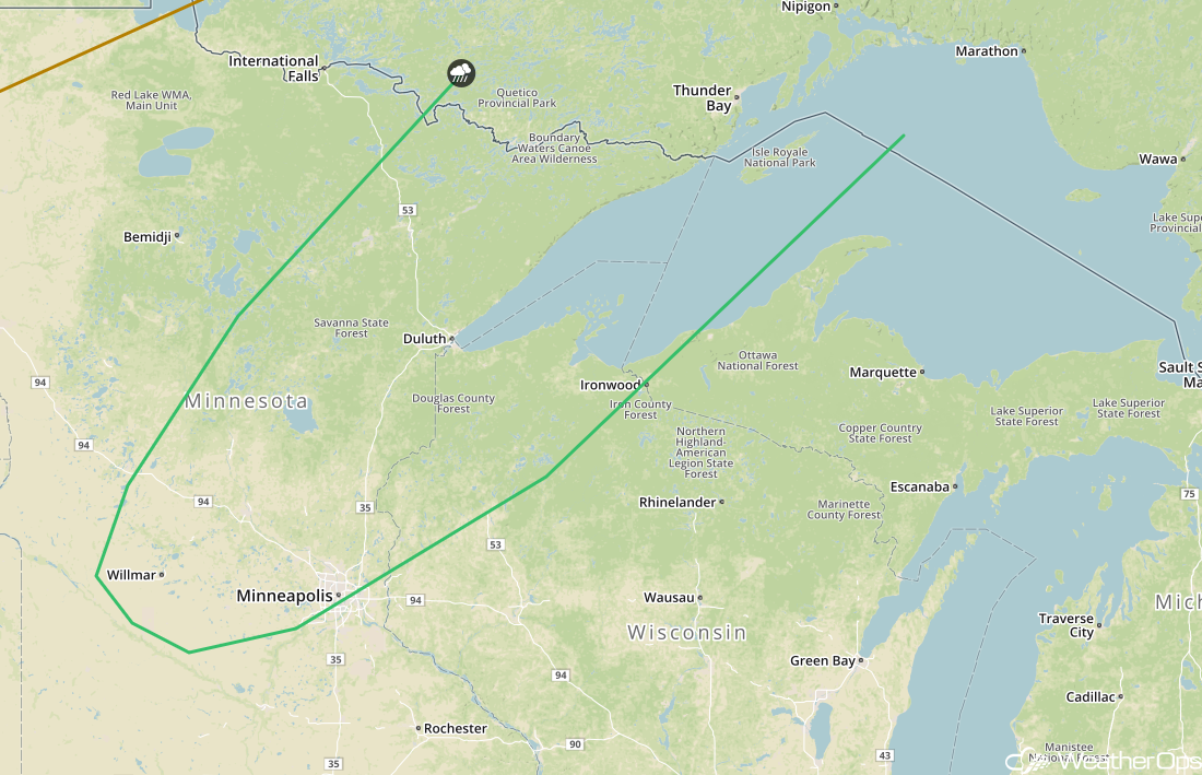 SPC Convective Outlook for Sunday
Thunderstorms Sunday for the Northeast
The cold front over the eastern Great Lakes and parts of the Northeast will continue to move to the east on Sunday. With plentiful moisture and daytime heating, instability may be sufficient for the development of thunderstorms. Strong winds and large hail will be the primary hazards with any storms that develop, but there will also be the potential for frequent lightning and heavy rain.
Major Cities in Region: Albany, NY, New York City, NY, Boston, MA, Portland, ME
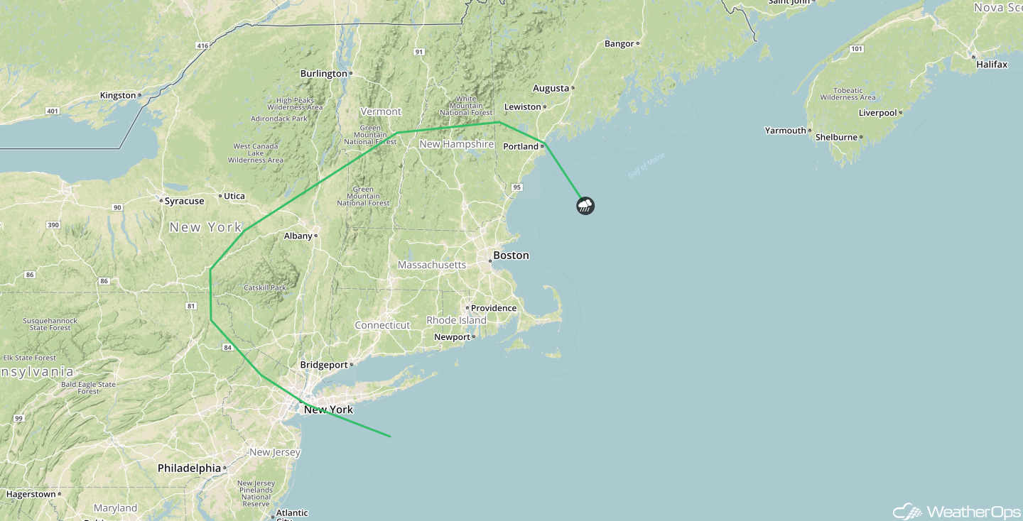
SPC Convective Outlook for Sunday
Tropical Update
An area of low pressure associated with the remnants of Beryl is located about 300 miles west of Bermuda. The associated shower and thunderstorm activity remains disorganized due to strong upper level winds. These winds are expected to become even less conducive for subtropical or tropical development over the next day or two while the low moves north-northeastward at 10 mph. Additional development will be limited once the low reaches colder waters by Saturday night or Sunday.
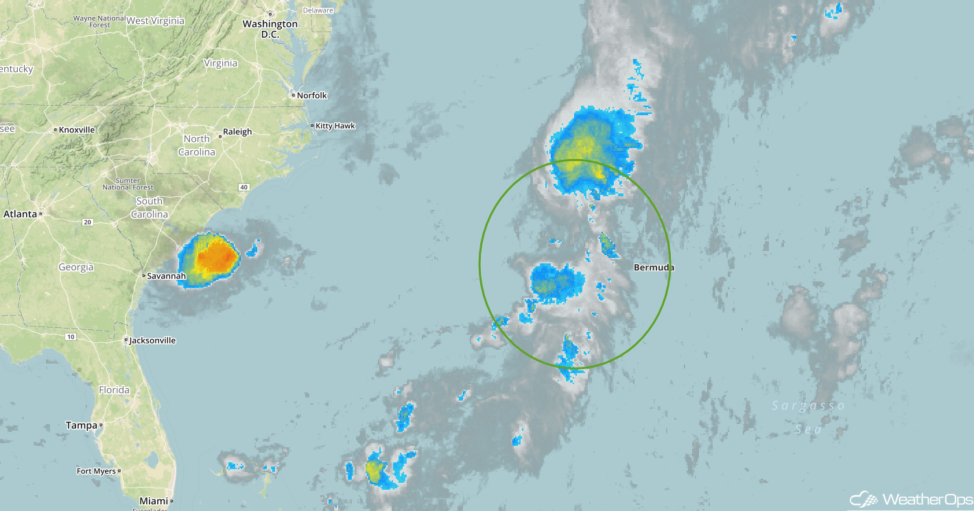
Enhanced Infrared Satellite
A Look Ahead
Showers and thunderstorms will extend from the Great Lakes into the Ohio Valley on Monday ahead of a cold front. As the cold front continues to move eastward on Tuesday, showers and thunderstorms will develop from the Northeast, through the Ohio Valley, and into the Southeast. Further west, showers may develop across portions of the Plains on Wednesday. By Thursday, a weak cold front may move into portions of the Southeast, bringing the potential for showers and thunderstorms to portions of southern Georgia and northern Florida.
