National Weather Summary for Friday, July 1, 2016
by David Moran, on Jul 1, 2016 12:05:17 PM
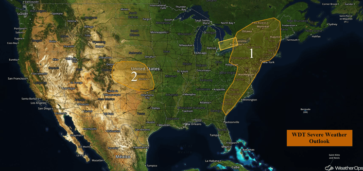
A cold front moving eastward from the Great Lakes and Ohio Valley, along with a nearly stationary front over the Southeast, will provide a focus for thunderstorm development across portions of the East Coast on Friday. Across the Plains, a weak upper level disturbance and cold front will move across the Central Plains, allowing for the development of thunderstorms. In addition to the risk for thunderstorms, heavy rain and flooding will be possible for portions of eastern Kansas and western Colorado. On Saturday, thunderstorms will be possible across the Carolinas and Mid Atlantic ahead of a cold front. A developing area of low pressure will allow for the development of thunderstorms from the Oklahoma-Kansas border into the High Plains. Heavy rain will also be possible for portions of the Plains. Thunderstorms will be possible across the Northern High Plains ahead of an upper level disturbance and a developing surface low. On Sunday, thunderstorms will be possible along a front extending from the Plains to the Mid Atlantic. A surface low developing across the Northern High Plains on Sunday may allow for the development of thunderstorms. Heavy rain will be possible across the Mid-Mississippi Valley and into the Ohio Valley along and near a warm front.
US Hazards
Region 1
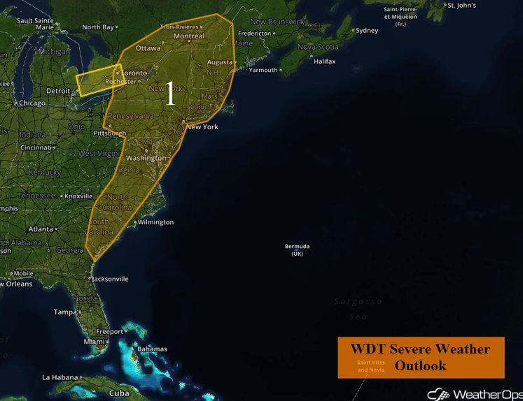
A slow moving cold front will act as a focus for rain and thunderstorm development across Region 1. The primary severe weather threat will be damaging winds in excess of 60 mph and large hail in excess of one inch in diameter. While the tornado threat is expected to be low, an isolated tornado or two cannot be completely ruled out. The greatest severe weather threat will exist during the afternoon and evening hours.
Region 1
Region 2
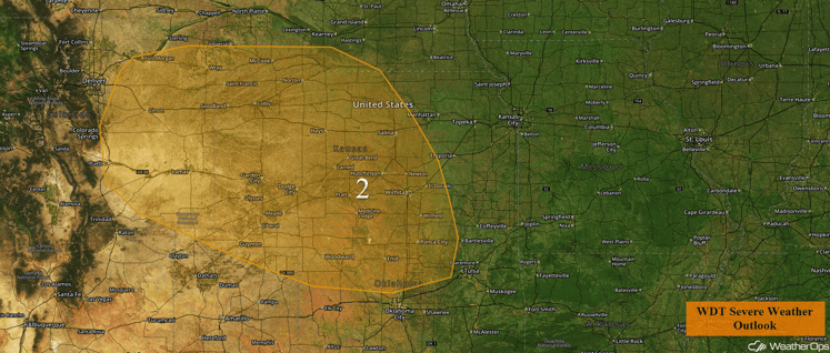
A weak stationary front, stretching across Region 2, will act as a focus for rain and thunderstorm development throughout the day on Friday. Conditions will be favorable for a few of these thunderstorms to become severe. The primary hazards will be large hail in excess of one inch in diameter and damaging wind gusts in excess of 60 mph. While the tornado threat is expected to be low, an isolated tornado or two cannot be completely ruled out. The greatest chances for severe weather will exist during the afternoon and evening hours, especially across eastern Colorado and western Kansas. In addition, excessive rainfall will be possible for portions of Eastern Colorado and Western Kansas. Rainfall amounts of 1-2 inches with locally higher amounts in excess of 3 inches will be possible, leading to an increased flooding threat.
Region 2
Strong to Severe Thunderstorms Possible for the Carolinas and Mid Atlantic on Saturday
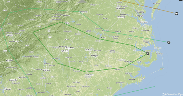
Increasing instability is expected to spread across much of the Carolinas, southern Virginia, and adjacent areas on Saturday as a cold front moves into the region and stalls. This frontal boundary will provide a focus for thunderstorm development, mainly during the afternoon and evening hours. Severe storms capable of producing large hail and damaging winds will be possible.
SPC Convective Outlook for Saturday
Strong to Severe Thunderstorms Possible Saturday for the Central and Southern Plains
A developing area of low pressure over the Central Plains is forecast to move little throughout the day, but will allow for a warm front to lift slightly northward. As instability increases through the afternoon, thunderstorms may develop across the Plains in the vicinity of the Oklahoma-Kansas border westward into the High Plains. Some of the storms could produce gusty winds and hail. In addition, heavy rain with rainfall amounts of 1-3 inches and locally higher amounts in excess of 4 inches will be possible across the region. Areas of eastern Kansas may be under an elevated risk of flash flooding.
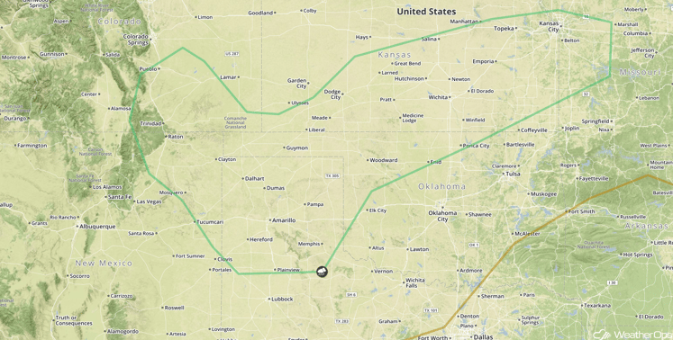
SPC Convective Outlook for Saturday
Strong to Severe Thunderstorms Possible Across the Northern High Plains on Saturday
An upper level disturbance, combined with a developing surface low over the Northern High Plains, will lead to a potential for thunderstorms across the region Saturday afternoon and evening. Most of the thunderstorm activity associated with this disturbance should remain to the north in Canada. However, isolated to marginally severe thunderstorms containing gusty winds may be possible across eastern Montana and western North Dakota.
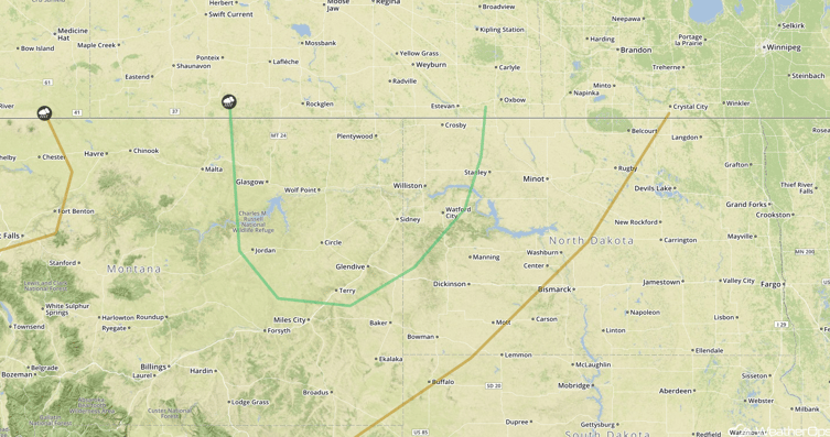
SPC Convective Outlook for Saturday
Strong to Severe Thunderstorms Possible from the Great Plains to East Coast on Sunday
A front extending east to west, from the eastern Plains to the Mid Atlantic coast, will provide a focus for thunderstorm development across the region on Sunday. Thunderstorms will be widespread along and north of the front, and more isolated to the south. However, conditions should be favorable for at least a few severe thunderstorms, with the greatest risk centered over the Mid-Mississippi Valley region. Damaging winds and large hail will be the primary threats, with a lower threat of isolated tornadoes. In addition, heavy rainfall will be possible from the Mid Mississippi Valley and into portions of the Ohio Valley. Many areas across Missouri and western Illinois will be under an increased threat of flash flooding as this should be the second day of heavy rainfall. Rainfall amounts of 1-3 inches with locally higher amounts in excess of 4 inches will be possible.
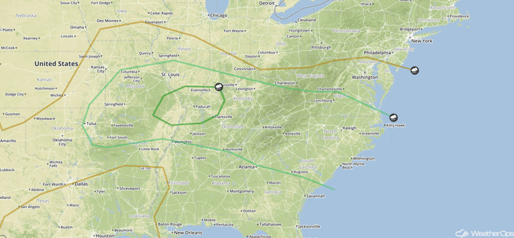
SPC Convective Outlook for Sunday
Strong to Severe Thunderstorms Possible for the Northern High Plains on Sunday
A surface low will continue to develop across the Northern High Plains on Sunday. Increasing stability during the afternoon and early evening may contribute to thunderstorm development, with a marginal risk of severe thunderstorms containing gusty winds and hail.
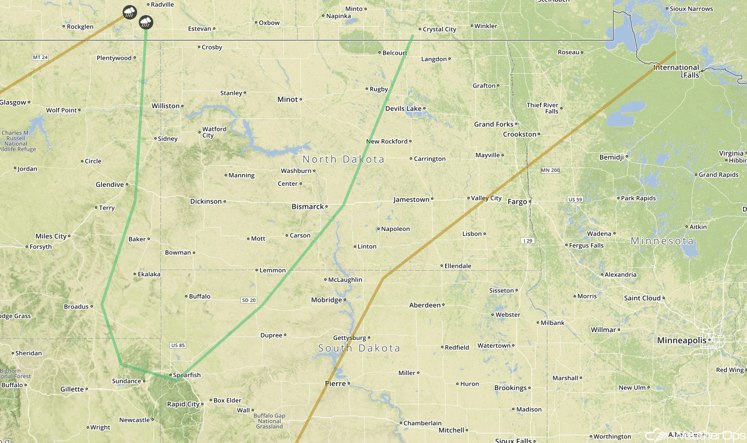
SPC Convective Outlook for Sunday
This is just a brief look at current weather hazards. We can provide you site-specific forecast information. Try a 7-day demo right away.


