by David Moran, on Jan 18, 2019 10:43:52 AM
Thunderstorms are forecast from the Southern Plains into the Lower Mississippi Valley on Friday ahead of a cold front. An area of low pressure will bring snow to portions of the Plains and Midwest. Snow will continue across the Rockies.
- Thunderstorms Friday from the Southern Plains into the Lower Mississippi Valley
- Snow from the Northern and Central Plains into the Midwest on Friday
- Continued Snow Friday across the Rockies
- Thunderstorm Potential for the Gulf Coast Saturday
- Excessive Rainfall Saturday for the Tennessee Valley
- Potential for Snow from the Midwest into the Ohio Valley on Saturday
- Snow Saturday and Sunday across the Northeast
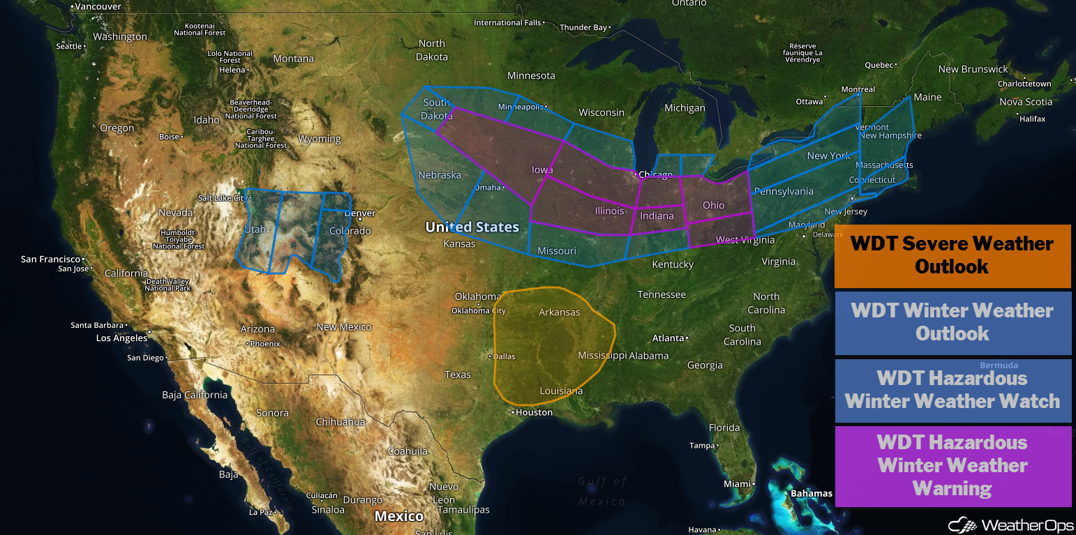
US Hazards
Thunderstorms Friday from the Southern Plains into the Lower Mississippi Valley
There will be a potential for strong to severe thunderstorms across portions of eastern Oklahoma and Texas into the Mississippi Valley on Friday as an area of low pressure moves eastward. Across the Arklatex area, the primary concern will be isolated strong to severe thunderstorms capable of producing large hail during the afternoon. Activity will become more widespread during the evening and overnight hours as a cold front moves through the region. Strong to damaging winds and isolated tornadoes will be the primary hazards with these storms.
Major Cities in Region: Shreveport, LA, Little Rock, AR, Memphis, TN, Jackson, MS
Thunderstorm Risk for Friday
Snow from the Northern and Central Plains into the Midwest on Friday
Significant winter weather is expected across portions of the Plains into the Midwest as a strong area of low pressure develops. Snowfall is increasing in coverage and intensity over South Dakota and this will persist while slowly shifting southeast. Accumulations of 4-8 inches with locally higher amounts in excess of 12 inches are expected across portions of South Dakota, southern Minnesota, Iowa, and northern Missouri by the end of Friday. Strong winds will lead to blowing snow, causing travel to become hazardous.
Major Cities in Region: Pierre, SD, Kansas City, MO, Des Moines, IA, Minneapolis, MN, Cedar Rapids, IA
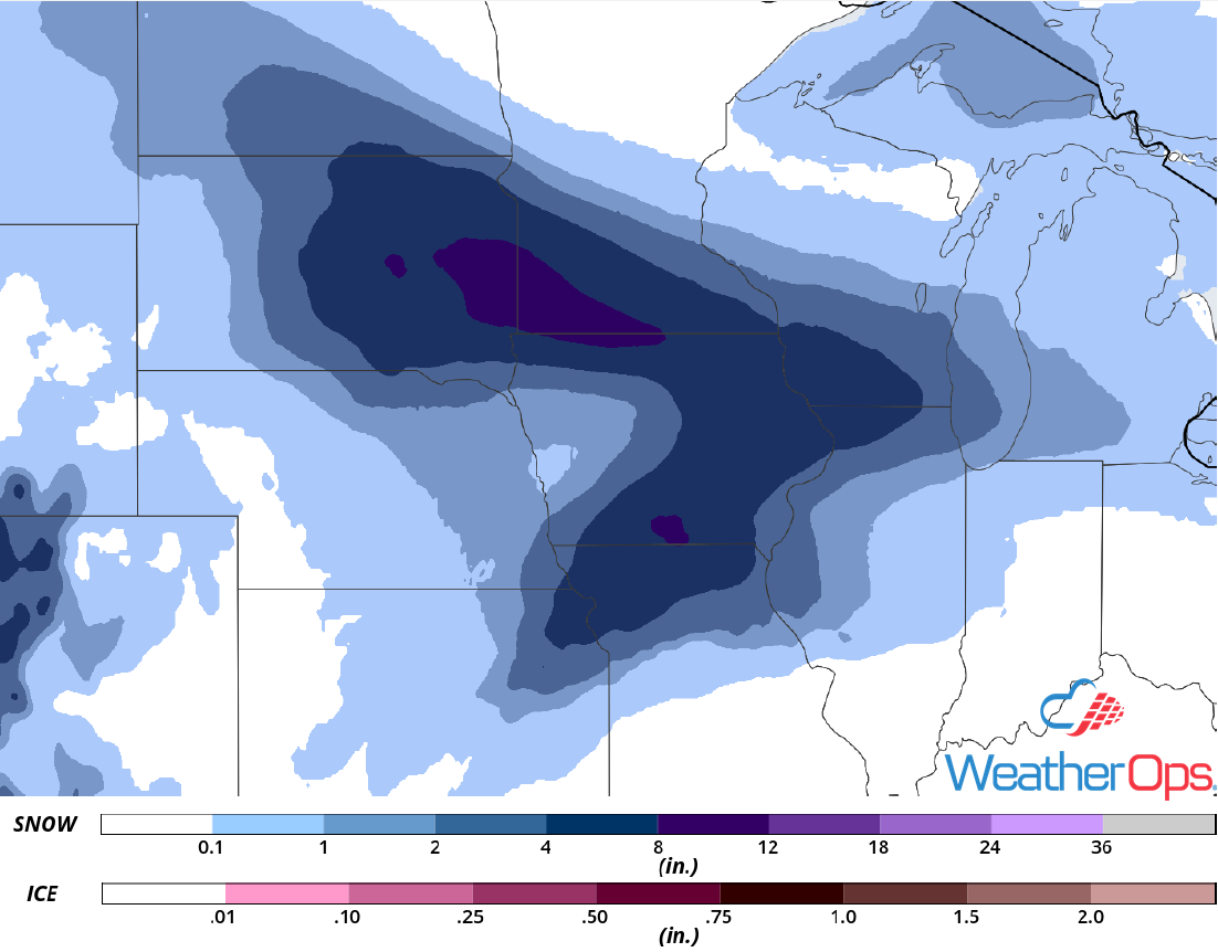
Snow Accumulation for Friday
Continued Snow Friday across the Rockies
Snow is ongoing across the Rockies as an area of low pressure intensifies over the High Plains. Moderate to heavy snow will continue for much of the day before tapering off during the evening. Accumulations of 4-8 inches with locally higher amounts in excess of a foot are expected in the higher elevations while 2-4 inches are expected in the lower elevations.
Major Cities in Region: Grand Junction, CO, Steamboat Springs, CO
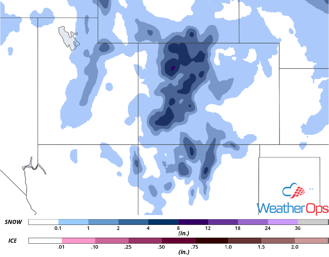
Snow Accumulation for Friday
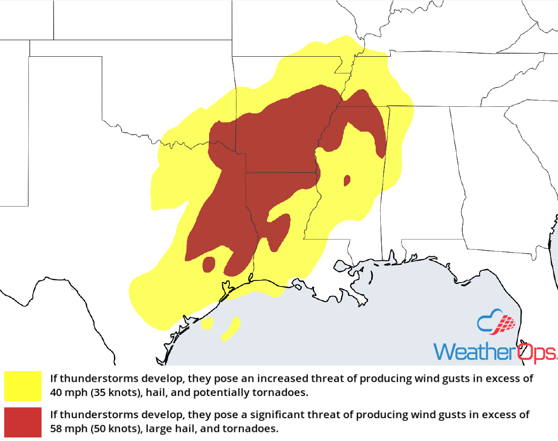
Thunderstorm Potential for the Gulf Coast Saturday
The potential for severe thunderstorms is increasing along the Gulf Coast on Saturday as a cold front associated with a strong area of low pressure continues to move eastward. Ongoing showers and thunderstorms during the morning will increase along and ahead of the front. Activity will be strong to severe through the afternoon and evening with damaging winds and tornadoes the primary hazards. As this activity moves into western Georgia during the early evening, the severe potential will diminish. Isolated strong to damaging winds cannot be ruled out over western Georgia during the evening.
Major Cities in Region: Lafayette, LA, Baton Rouge, LA, New Orleans, LA, Jackson, MS, Mobile, AL, Birmingham, AL, Tallahassee, FL, Atlanta, GA, Macon, GA
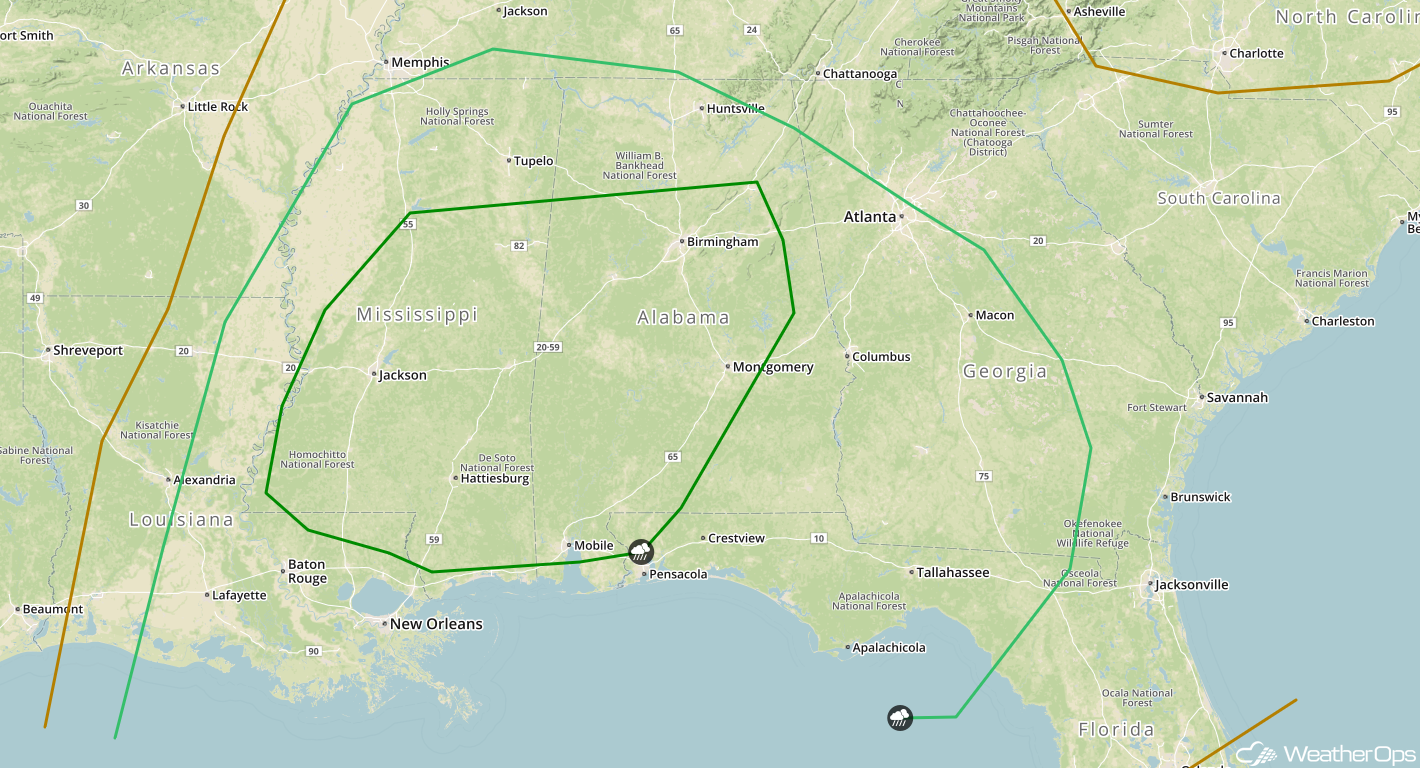
SPC Convective Outlook for Saturday
Excessive Rainfall Saturday for the Tennessee Valley
There will be a potential for heavy to excessive rainfall over the Tennessee Valley as the area of low pressure described above progresses eastward. Ample moisture will move northward ahead of the low, allowing for the development of scattered to widespread showers and thunderstorms ahead of the cold front. Heavy rainfall will be most likely over the Tennessee Valley during the afternoon and evening where widespread rainfall totals of 1-2 inches with locally higher amounts in excess of 3 inches are expected. This will lead to a slight risk for flooding.
Major Cities in Region: Nashville, TN, Lexington, KY, Chattanooga, TN
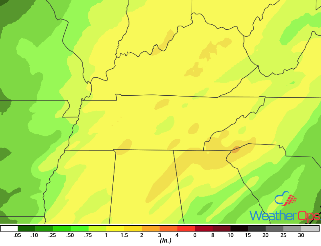
Rainfall Accumulation for Saturday
Potential for Snow from the Midwest into the Ohio Valley on Saturday
Moderate to heavy snow is expected over the Midwest into the southern Great Lakes Saturday morning as an area of low pressure moves into the Mississippi Valley. This low will move eastward during the day and a large band of snow will follow. A large swath of 3-6 inches with locally higher amounts in excess of 8 inches is expected over the southern Great Lakes into northern Illinois and Indiana on Saturday. By Saturday evening, the low will move northeastward and snowfall rates will increase over Ohio. In this area, accumulations over 8 inches are likely, along with significant icing, within the transition zone over southern Ohio. Strong winds will cause blowing snow and reduced visibility over the Ohio Valley. This will cause widespread travel impacts across the region.
Major Cities in Region: Springfield, IL, Indianapolis, IN, Columbus, OH, Cleveland, OH
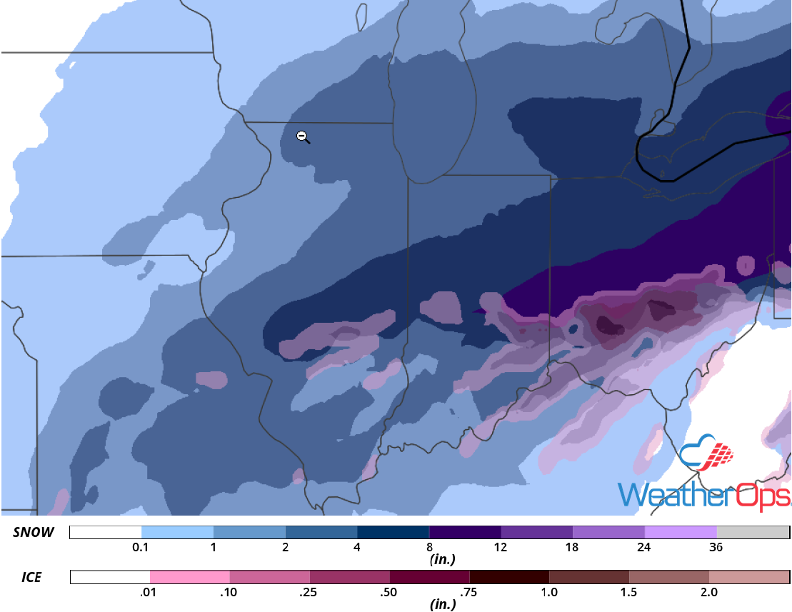
Snow Accumulation for Saturday
Snow Saturday and Sunday across the Northeast
A significant Nor'Easter is expected to impact the Northeast this weekend and cause widespread travel disruptions. The surface low will intensify while tracking along the coast, with snow beginning on Saturday and continuing into Sunday. A large area of 8-12 inches with locally higher amounts is likely from northeast Pennsylvania into Upper New York. Accumulations of 1-2 feet are expected from Upper New York into Maine. The location of the heaviest snow will depend on the track of the surface low. As a result, the forecast may shift slightly over the next day. In addition to the heavy snow, significant freezing rain is forecast within the transition zone over coastal New England. Ice accumulation in excess of 0.25 inch is forecast from northern New Jersey into Massachusetts.
Major Cities in Region: New York, NY, Albany, NY, Burlington, VT, Augusta, ME
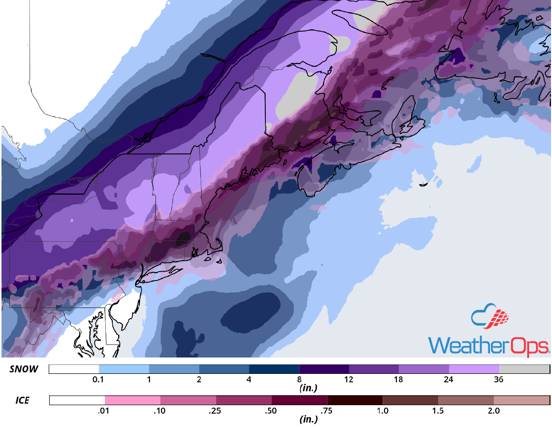
Snow Accumulation for Saturday and Sunday
A Look Ahead
Light to moderate snow will move across the Rockies on Monday as an area of low pressure moves eastward. This snow will move into the Plains and Upper Midwest on Tuesday. As the system continues to move eastward on Wednesday, snow is expected from the Appalachians into the Northeast. Light snow may develop across the Upper Midwest on Thursday.