


by David Moran, on Feb 9, 2018 10:28:38 AM
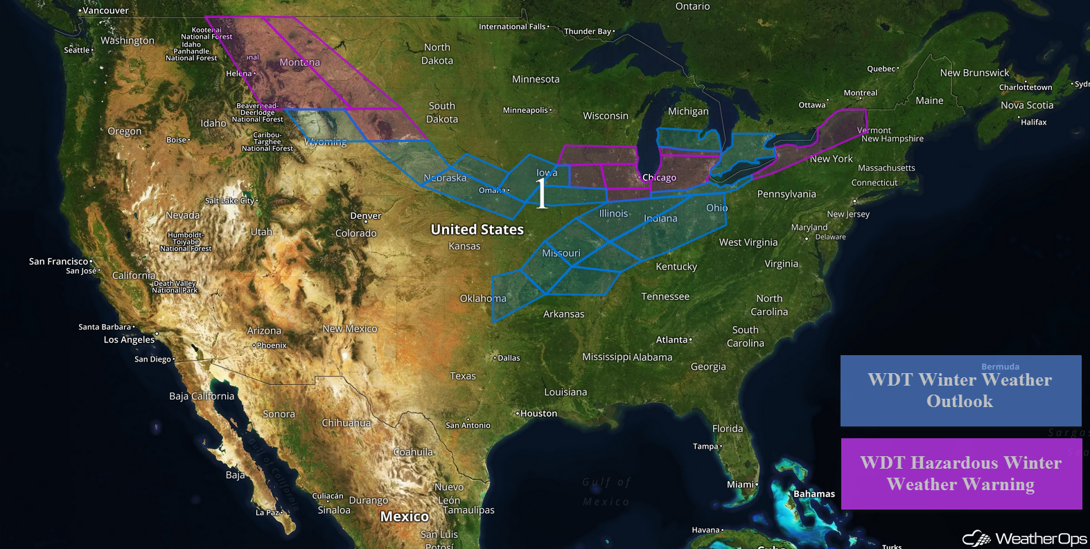
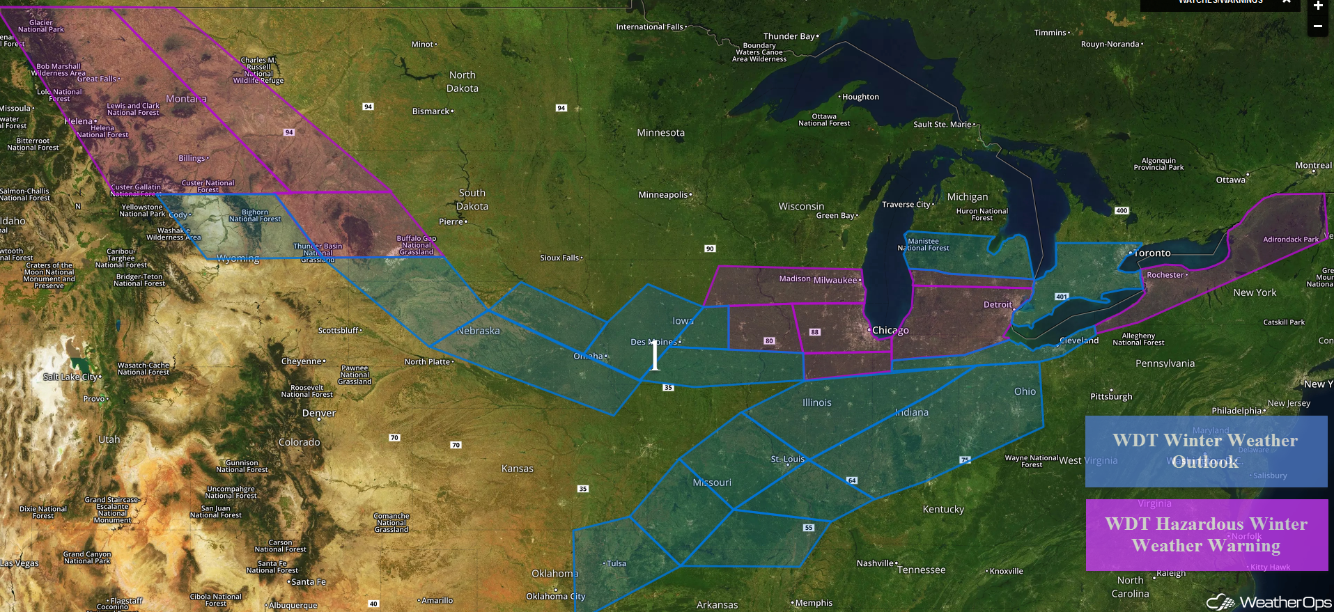
Freezing rain and snow will continue from the Northern Rockies into the Northeast through Sunday.
- Wintry Precipitation Continuing from the Northern Rockies into the Northeast through Sunday
 US Hazards

Wintry Precipitation Continuing from the Northern Rockies into the Northeast through Sunday
Snow will continue for portions of the Northern Rockies through early Saturday morning. Across central Montana, 5-10 inches of snow are expected in the lower elevations and 12-20 inches in the higher elevations. For eastern portions of Montana, 4-6 inches of snow with locally higher amounts in excess of 8 inches are forecast. From northeastern Wyoming into western South Dakota, snow accumulations will range 3-6 inches with locally higher amounts in excess of 7 inches. Winds gusting to 30-40 mph will allow for blowing snow and low visibilities.
From southwestern South Dakota into central Iowa, snow accumulations of 2-4 inches with locally higher amounts in excess of 6 inches are expected. Across eastern Iowa into southern Wisconsin, 4-6 inches of snow with locally higher amounts in excess of 7 inches are expected.
Further east across northeastern Illinois and northwestern Indiana, 6-9 inches of snow with locally higher amounts in excess of 11 inches are expected through Friday evening. Areas just south of Chicago may pick up 3-6 inches with locally higher amounts. Across southern portions of Michigan, northern portions of Indiana, and northwestern Ohio, snowfall accumulations of 7-9 inches and locally higher amounts in excess of 11 inches are forecast. For northern portions of the Lower Peninsula of Michigan, 3-6 inches with locally higher amounts in excess of 7 inches are expected through Friday.
Snow accumulations of 2-4 inches are forecast from north central Indiana into northeastern Ohio. For portions of western and central New York, 4-8 inches of snow are expected through Sunday evening.
Further south from eastern Oklahoma into the Ohio Valley, light snow and freezing rain are forecast Saturday morning through Sunday morning. Across eastern Oklahoma, freezing rain accumulations up to a tenth of an inch are expected. Further northeast across the central and southern portions of Missouri, ice accumulations of 0.10-0.25 inch with locally higher amounts are expected. Snowfall accumulations up to 2 inches will also be possible, with locally higher amounts.
Across southeastern portions of Missouri and southern Illinois, freezing rain accumulations of 0.05-0.15 inch with locally higher amounts are expected. Snow amounts will range from a trace to 2 inches, though there may be a few isolated amounts higher than 3 inches.
From central Illinois into northern Illinois, snowfall amounts will range 1-3 inches. Some light icing may also develop. Across southern Illinois into central Ohio, freezing rain and snow will begin Saturday evening into Sunday evening. Ice accumulations will range 0.1-0.2 inch with locally higher amounts. In addition, snow accumulations up to an inch are expected.
Major Cities in Region: Helena, MT, Great Falls, MT, Billings, MT, Rapid City, SD, Tulsa, OK, Omaha, NE, Des Moines, IA, St. Louis, MO, Milwaukee, WI, Chicago, IL, Indianapolis, IN, Detroit, MI, Cleveland, OH, Buffalo, NY, Syracuse, NY, Burlington, VT
 Region 1
A Look Ahead
Generally calm conditions are expected for much of the country on Monday and Tuesday, except for some light snow for the Northern Rockies and Cascades. By Wednesday, rain chances will increase across the Southeast, Ohio Valley, and Mid Atlantic.
That is a brief look at current weather hazards. We can provide you site-specific weather forecast information to protect your staff and assets and to assess your weather risk. Try a 7-day demo right away and learn how timely precision weather information can enhance your bottom line.
