


by David Moran, on Feb 23, 2018 11:01:41 AM
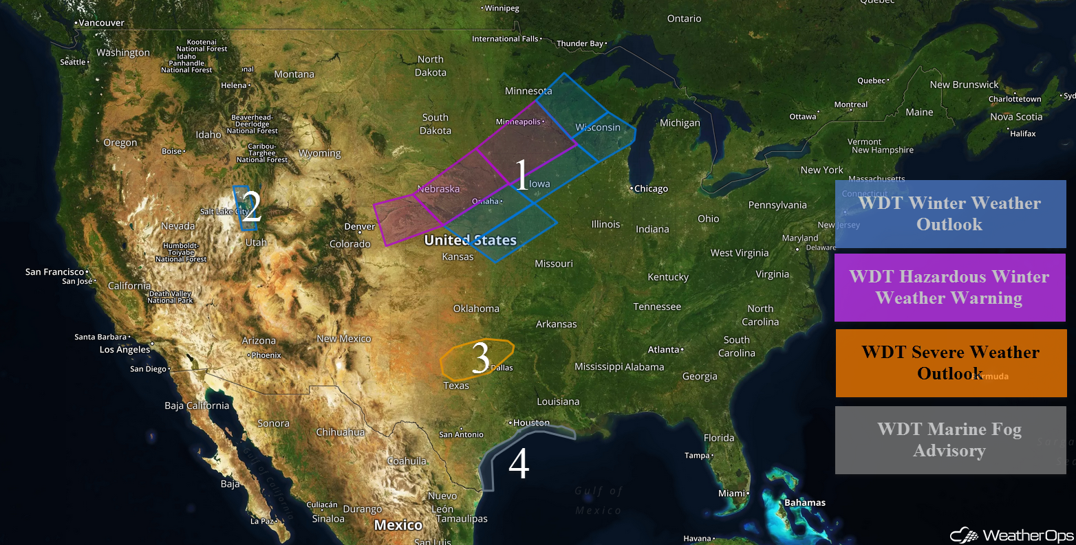
Another round of wintry precipitation is expected late Friday through Sunday across the Central and Northern Plains as an area of low pressure forms over the region. Light snow will continue for portions of Utah through Friday afternoon. Thunderstorms may develop over portions of north Texas and southern Oklahoma as an upper level trough moves over the region. Dense fog will continue for the Texas and Louisiana coasts through the morning.
- Freezing Rain and Snow for the Plains through Early Sunday
- Snow for Portions of Utah through Friday Afternoon
- Thunderstorms Friday for North Texas and Southern Oklahoma
- Dense Fog for the Texas and Louisiana Coasts through Friday Morning
- Excessive Rainfall through Sunday for the Southern Plains into the Ohio Valley
- Severe Thunderstorms Expected from the Arklatex Region to the Tennessee Valley on Saturday
 US Hazards

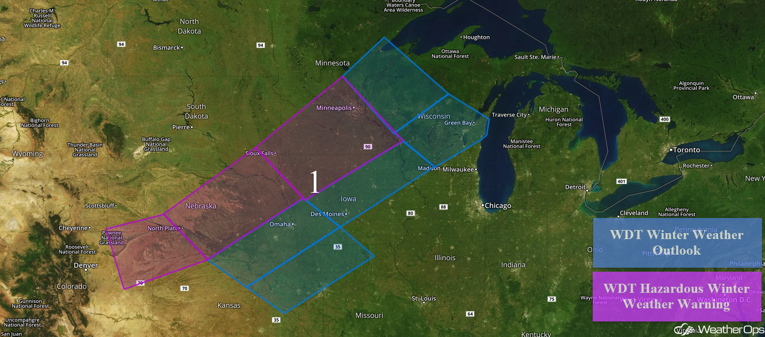
Freezing Rain and Snow for the Plains through Early Sunday
Light snow will develop across portions of the Central High Plains late Friday into Saturday as an area of low pressure develops in the Rockies. Snow accumulations of 2-4 inches with locally higher amounts are forecast across portions of northeastern Colorado, southwestern Nebraska, and northwestern Kansas. From central Nebraska into southeastern South Dakota, 4-7 inches with locally heavier amounts in excess of 8 inches are forecast. Across north central Kansas into southwestern Iowa, snowfall accumulations will range 1-3 inches with locally higher amounts in excess of 4 inches. In addition, ice accumulations of 0.05-0.15 inch are expected.
For northeastern Kansas and northwestern Missouri, up to an inch of snow and 0.05-0.15 inches of ice are forecast. Across southeastern South Dakota, northern Iowa, and southern Minnesota, 4-8 inches with locally higher amounts in excess of 10 inches are expected. In addition, winds of 20-30 mph will allow for blowing snow and low visibilities. For central Minnesota and northwestern Wisconsin, 3-6 inches with locally higher amounts in excess of 7 inches are expected. From central Iowa to southwestern Wisconsin, snow accumulations will range 1-3 inches in addition to ice accumulations will range 0.05-0.15 inch. For central and northeastern Wisconsin, snowfall accumulations will range 1-3 inches with locally higher amounts in excess of 4 inches are expected in addition to ice accumulations of 0.05-0.15 inches.
Major Cities in Region: North Platte, NE, Sioux Falls, SD, Omaha, NE, Kansas City, MO, Des Moines, IA, Minneapolis, MN, Green Bay, WI
 Region 1
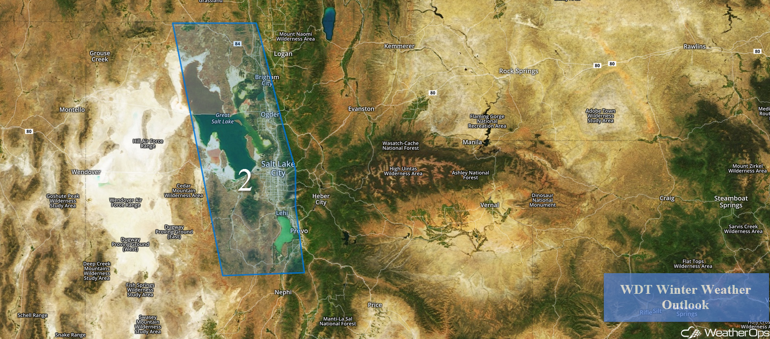
Snow for Portions of Utah through Friday Afternoon
Light snow will continue for portions of Utah through the afternoon. Total snowfall accumulations will range from 2-4 inches. Travel may be hazardous at times.
Major Cities in Region: Salt Lake City, UT, Provo, UT
 Region 2
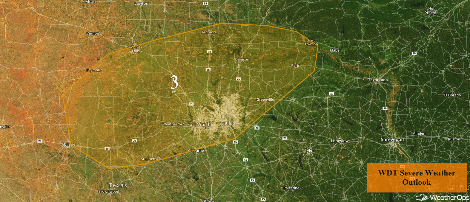
Thunderstorms Friday for North Texas and Southern Oklahoma
Thunderstorms may develop across portions of north Texas and Southern Oklahoma ahead of an upper level trough. While activity is currently ongoing, another round of thunderstorms may develop during the afternoon. Hail and damaging winds will be the primary hazards with these storms.
Major Cities in Region: Abilene, TX, Fort Worth, TX, Dallas, TX, Denison, TX
 Region 3
Dense Fog for the Texas and Louisiana Coasts through Friday Morning
Fog will continue along the Texas and Louisiana coasts through the morning. Visibilities will be less than a mile at times.
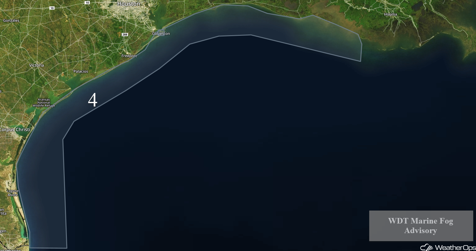 Region 4
Excessive Rainfall through Sunday for the Southern Plains into the Ohio Valley
The threat for excessive rainfall will continue from the Southern Plains into the Ohio Valley through Sunday along a stalled front. Three day rainfall call for totals of 3-7 inches with locally higher amounts in excess of 9 inches. This will lead to additional flooding and flash flooding concerns.
Major Cities in Region: Dallas, TX. Shreveport, LA, Memphis, TN, Jackson, MS, Birmingham, AL, Knoxville, TN, Pittsburgh, PA
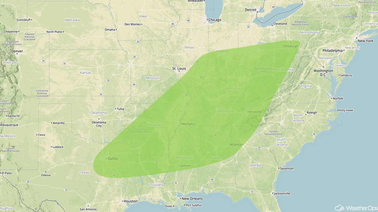 Excessive Rainfall Risk Outline for Friday through Sunday
Severe Thunderstorms Expected from the Arklatex Region to the Tennessee Valley on Saturday
Strong to severe thunderstorms are expected to develop on Saturday. Instability and wind shear will increase throughout the day resulting in the intensification of ongoing thunderstorms and further development along the cold front. Hail, damaging winds, and tornadoes will all be potential hazards with these storms. A few strong tornadoes cannot be ruled out with the highest tornado threat across Arkansas and western Tennessee.
Major Cities in Region: Dallas, TX, Shreveport, LA, Little Rock, AR, Memphis, TN, Evansville, IN, Nashville, TN
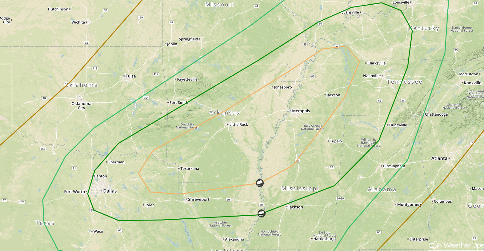 SPC Convective Outlook for Saturday
A Look Ahead
An area of low pressure will track from the Central Plains toward the Northeast on Wednesday. This system's associated warm front will lift northward into the Mid Atlantic and its associated cold front will track across the Mississippi River Valley by Thursday. To the south of this warm front, and east of the cold front, multiple rounds of rain and thunderstorm activity are anticipated. At this time, model guidance suggests widespread rainfall amounts of 1-3 inches with locally higher amounts in excess of 4 inches will be possible across portions of the Tennessee River Valley and the Southeast on Wednesday and Thursday. This will allow the flooding and flash flooding threat to continue.
That is a brief look at current weather hazards. We can provide you site-specific weather forecast information to protect your staff and assets and to assess your weather risk. Try a 7-day demo right away and learn how timely precision weather information can enhance your bottom line.
