


by David Moran, on Feb 22, 2019 11:21:08 AM
Thunderstorms are expected across the Lower Mississippi Valley on Friday as a warm front moves northward. These thunderstorms will have the potential to produce excessive rainfall. Snow will continue across the Four Corners region as an area of low pressure intensifies. An area of low pressure will bring snow to the Northern Plains through Saturday. Snow is expected across the Central Plains through Saturday as a system moves across the region. Fog will persist along the Texas and Louisiana coasts through Friday night.
- Thunderstorms for the Lower Mississippi Valley on Friday
- Excessive Rainfall Friday for the Lower Mississippi Valley
- Snow for the Four Corners Region Friday
- Potential for Snow through Saturday across the Northern Plains
- Snow for the Central Plains through Saturday
- Fog through Friday Night along the Gulf Coast
- Potential for Thunderstorms across the Lower Mississippi Valley on Saturday
- Excessive Rainfall Saturday from the Lower Mississippi Valley into the Tennessee Valley
- Thunderstorms for the Louisiana Delta Sunday
- Snow Sunday from the Cascades into Idaho
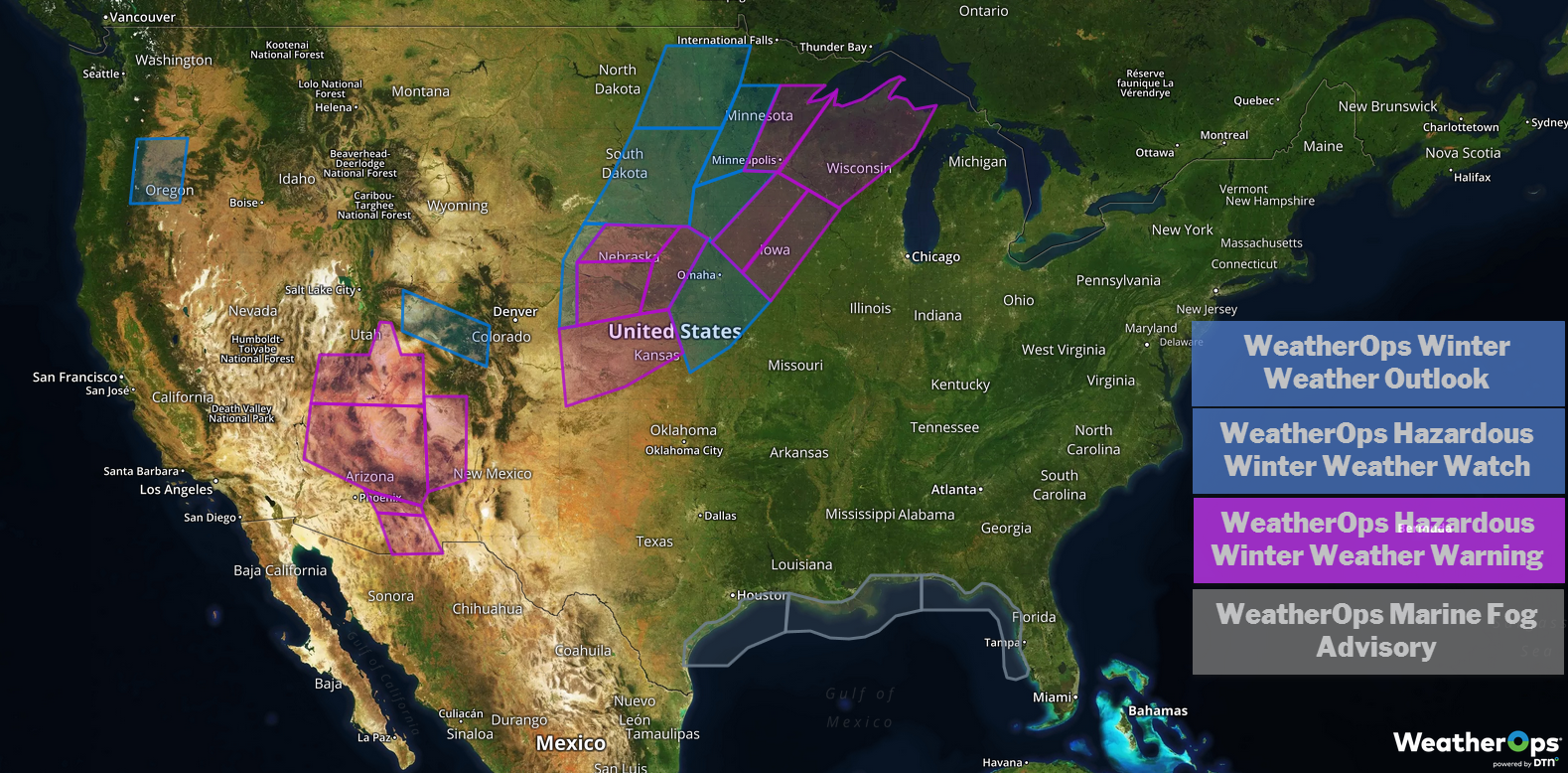
US Hazards
Thunderstorms for the Lower Mississippi Valley on Friday
Strong thunderstorms are likely across the southern Gulf States as a warm front lifts northward. Ongoing activity will continue throughout the day, intensifying during the afternoon and evening. Gusty winds, small hail, and frequent lightning will be the primary hazards with these storms.
Major Cities in Region: Monroe, LA, Baton Rouge, LA, Memphis, TN, Jackson, MS, New Orleans, LA
Thunderstorm Risk for Friday
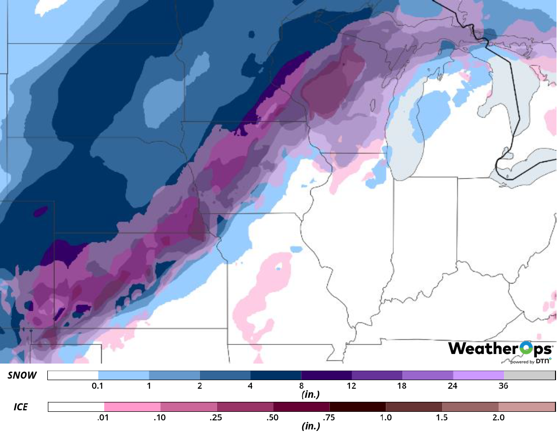
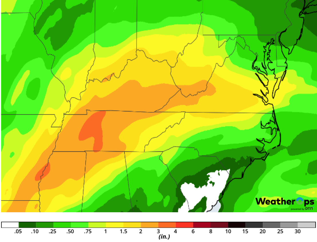
Excessive Rainfall Friday for the Lower Mississippi Valley
In addition to the thunderstorms above, there will be a potential for excessive rainfall and flooding. Rainfall amounts will range 2-4 inches with locally higher amounts in excess of 6 inches.
Major Cities in Region: Monroe, LA, Memphis, TN
Rainfall Accumulation for Friday
Snow for the Four Corners Region Friday
As an area of low pressure intensifies over the Four Corners region, snowfall will continue today. Snowfall accumulations will range 5-10 inches with locally higher amounts in excess of a foot. Wind gusts in excess of 30 mph will allow for blowing snow, creating hazardous travel conditions. Freezing rain accumulations up to 0.10 are forecast across southern Arizona as temperatures hover around freezing.
Major Cities in Region: Phoenix, AZ, Truth or Consequences, NM, Durango, CO
Snow Accumulation for Friday
Potential for Snow through Saturday across the Northern Plains
An upper level trough moving out of the Rockies will bring mid level moisture across the region, producing light to moderate snow. Widespread accumulations of 3-6 inches with locally higher amounts in excess of 8 inches are expected with the higher amounts across the Dakotas into Minnesota.
Major Cities in Region: Pierre, SD, Grand Forks, ND, Sioux Falls, SD, Minneapolis, MN
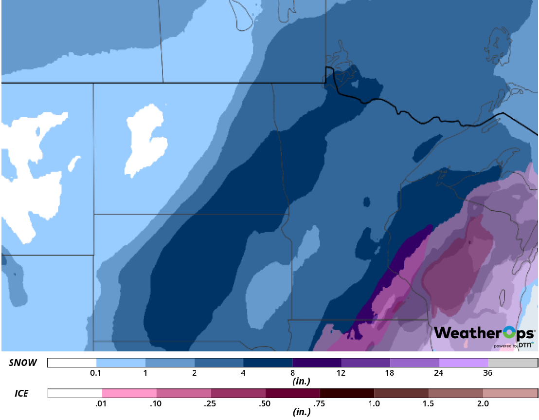
Snow Accumulation for Friday and Saturday
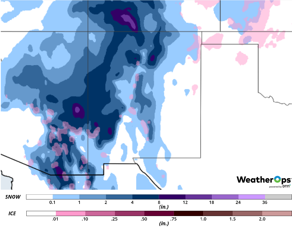
Snow for the Central Plains through Saturday
As the main area of low pressure intensifies over the Central Plains, snowfall will continue through Saturday. Snowfall totals will range 6-8 inches with locally higher amounts in excess of 10 inches. Surface temperatures just above freezing to the south of the region could bring freezing rain and sleet to the region on Saturday; accumulations up to 0.10 inch are expected. In addition, winds behind the front will be northwesterly in excess of 25 mph with gusts in excess of 50 mph, resulting in blowing snow and hazardous travel conditions.
Major Cities in Region: Dodge City, KS, Topeka, KS, Omaha, NE, Des Moines, IA
Snow Accumulation for Friday and Saturday
Fog through Friday Night along the Gulf Coast
Light winds and abundant moisture will allow for the development of fog along the Gulf Coast. Visibilities will be less than half a mile at time. Later in the day, winds will increase, allowing fog to dissipate and visibilities to improve.
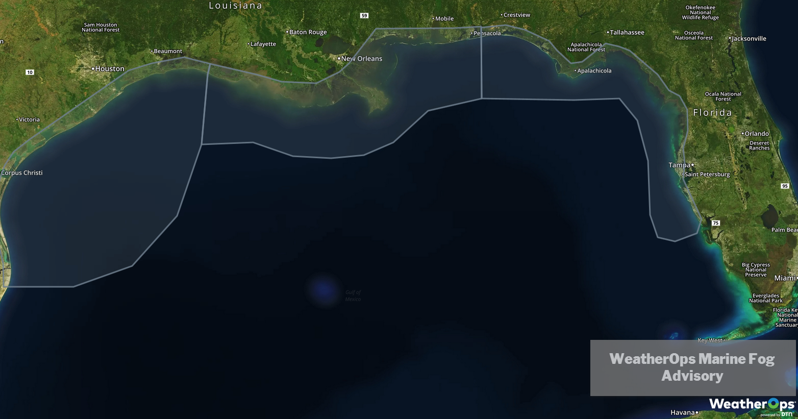
WeatherOps Marine Fog Advisory
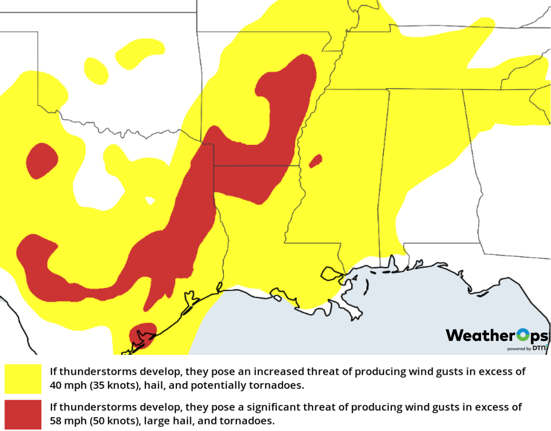
Potential for Thunderstorms across the Lower Mississippi Valley on Saturday
As a trough continues to develop over the Southern Plains, the associated cold front will move through the region on Saturday, allowing for the development of thunderstorms. Activity will be linear in nature, beginning to intensify over eastern Texas and Louisiana during the afternoon. This activity will move eastward during the evening. Large hail, damaging winds, and tornadoes will be potential hazards with these storms.
Major Cities in Region: Shreveport, LA, Little Rock, AR, Memphis, TN, Jackson, MS
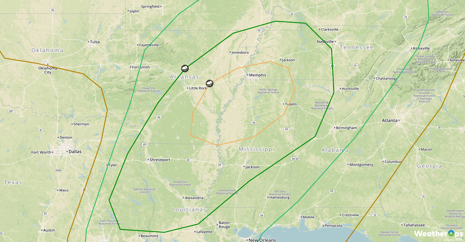
SPC Convective Outlook for Saturday
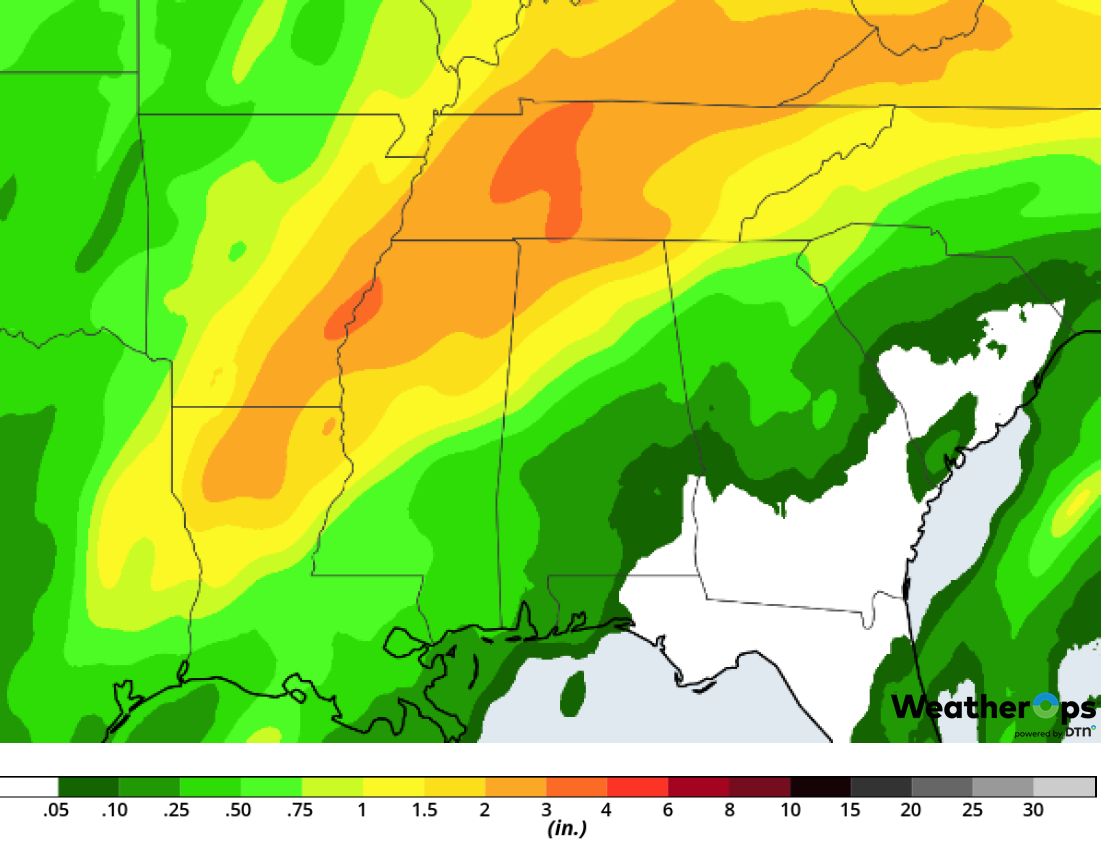
The thunderstorms described above will also have the potential to produce excessive rainfall. Rainfall amounts of 1-3 inches with locally higher amounts in excess of 4 inches are expected, leading to the potential for flooding. The highest rainfall totals will likely occur across central Kentucky and northern Tennessee.Major Cities in Region: Monroe,. LA, Memphis, TN, Nashville, TN, Lexington, KY, Chattanooga, TN
Rainfall Accumulation for Saturday
Thunderstorms for the Louisiana Delta SundayAs the cold front described above continues to move eastward, thunderstorms may develop across the region on Sunday. Strong winds, lightning, and small hail will be the primary hazards with these storms. Major Cities in Region: Mobile, AL, Pensacola, FL, Panama City, FL
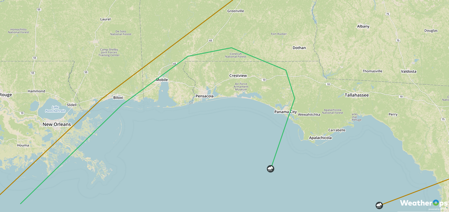
SPC Convective Outlook for Sunday
Snow Sunday from the Cascades into IdahoAn area of low pressure will move onshore this weekend, bringing significant snowfall to the region. Accumulations of 2-3 feet are expected above 7,000 feet and 6-12 inches in the lower elevations. Major Cities in Region: Bend, OR, Yakima, WA. Idaho Falls, ID
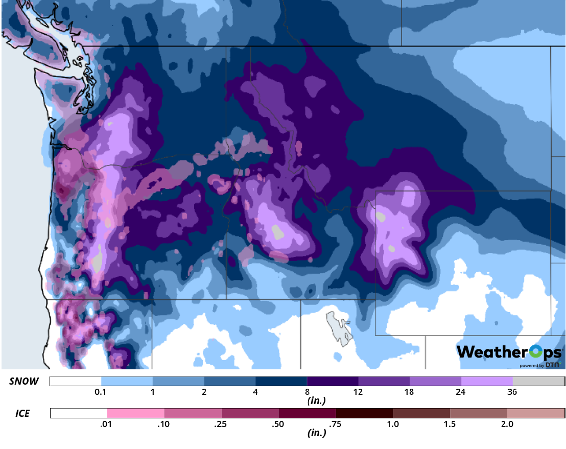
Snow Accumulation for Sunday
A Look Ahead
Light snow is expected across portions of the Northeast on Monday as an area of low pressure moves eastward. Snow may develop over the Northern Plains and Upper Midwest as a disturbance moves across the region. By Tuesday, snow will spread into the Great Lakes. As the disturbance moves eastward, snow is expected to develop across the Northeast. Further west, snow is forecast across the Northern Rockies Wednesday into Thursday.
