National Weather Summary for Friday, December 9, 2016
by David Moran, on Dec 9, 2016 12:01:36 PM
Heavy snow will continue for the Pacific Northwest and Northern Rockies Friday into the weekend as an area of low pressure moves through the region. Strong winds and elevated seas will persist for the Gulf of Mexico through early Saturday as a cold front continues to move across the Gulf. As an area of low pressure tracks through the Rockies, snow is likely for portions of Colorado Saturday afternoon into Sunday. Snow will be likely for portions of the Northern Plains and into the Great Lakes Saturday into Sunday as an area of low pressure moves eastward.
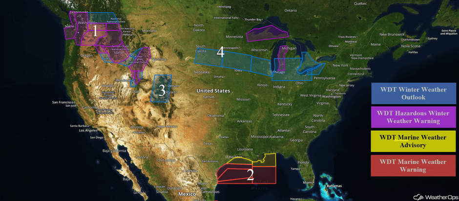 US Hazards
Region 1
Snow will continue across portions of the Pacific Northwest Friday through Sunday as an area of low pressure moves through the region. Snowfall accumulations of 4-7 inches will be possible for portions of Idaho, Oregon, and Washington through Saturday. Snow will continue into Sunday across the Cascades with an additional 6-10 inches above 4,000 feet and locally higher amounts in excess of 18 inches above the timberline and in mountain passes likely. Across central and southeastern Idaho, 5-10 inches of snow will be possible in the valleys with 10-15 inches for the higher elevations. The heaviest snow will likely be across southeastern Idaho and western Wyoming where 8-12 inches of snow will be possible in the valleys and up to 2 feet in the higher elevations. In addition, winds of 25-35 mph with gusts in excess of 50 mph will be possible.
Major Cities in Region: Seattle, WA, Spokane, WA, Boise, ID, Missoula, MT, Salt Lake City, UT
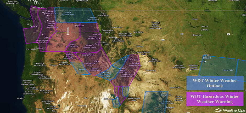 Region 1
Region 2
Elevated winds and seas will continue across portions of the Gulf of Mexico in the wake of a cold front that moved through the region. Northeasterly to north-northeasterly winds at 30-35 knots with gusts in excess of 45 knots will be possible. Seas of 12-16 feet are anticipated but will subside to below 10 feet Friday evening. Across eastern portions of Region 2, seas will be 10-14 feet before subsiding Saturday morning.
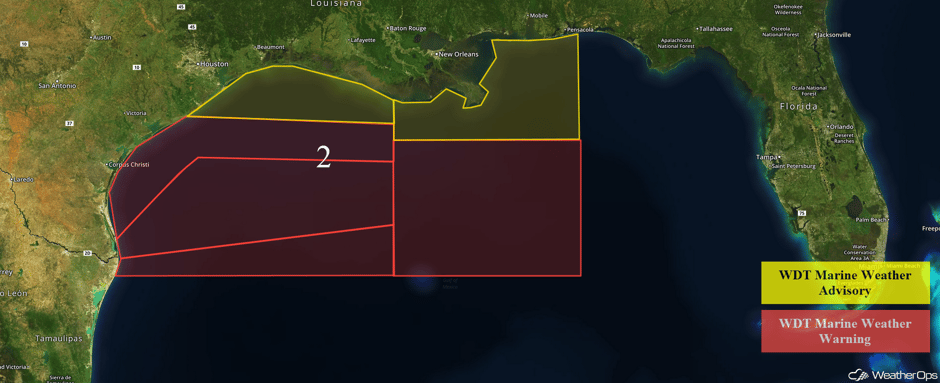 Region 2
Region 3
An area of low pressure is forecast to track over the Rockies and to the southeast, bringing heavy snowfall to the region Saturday into Sunday. Total snowfall accumulations of 12-18 inches will be possible in the higher elevations with 8-12 inches possible in the valleys. Gusty winds will result in blowing snow, reduced visibilities, and wind chills in the single digits.
Major Cities in Region: Grand Junction, CO, Aspen, CO
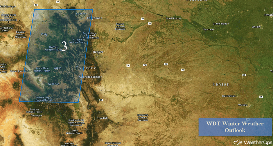 Region 3
Region 4
An area of low pressure will develop in the lee of the Rockies Friday night and move eastward. Light to moderate snow will likely develop across portions of South Dakota Saturday morning and continue for much of the day. Snowfall amounts of 3-5 inches with locally higher amounts in excess of 6 inches will be possible. In addition, winds of 10-20 mph will bring below zero wind chills to the region. As the low continues to move eastward, heavy snow is forecast for much of the Great Lakes. Snowfall accumulations of 2-4 inches will be possible for portions of northern Illinois and southern Wisconsin Saturday afternoon through early Sunday morning.
From Saturday evening through Monday morning, heavy snow is expected across the Lower Peninsula of Michigan, northeastern Illinois, and northern portions of Indiana and Ohio. Snowfall amounts of 4-8 inches with locally higher amounts in excess of 12 inches will be possible. In addition to the snow, winds of 10-20 mph and gusts in excess of 25 mph will allow for low wind chills and limited visibilities. Lake effect snow will continue for portions of western New York and northwestern Pennsylvania through early Saturday afternoon. Snow accumulations of 4-6 inches with locally higher amounts in excess of 8 inches will be possible. In addition to the snow, winds are forecast to be 15-25 mph with gusts in excess of 30 mph. This will allow for low wind chills and visibilities below a mile at times.
Major Cities in Region: Pierre, SD, Sioux Falls, SD, Madison, WI, Milwaukee, WI, Chicago, IL, Grand Rapids, MI, Detroit, MI, Cleveland, OH, Buffalo, NY
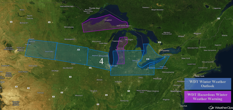 Region 4
A Look Ahead
As an area of low pressure moves northeastward through southern Ontario on Monday, heavy snowfall is likely for portions of Upstate New York and New England. Snow amounts of 6-10 inches with locally higher amounts n excess of a foot will be possible. Another round of snow will be likely across the Northeast on Tuesday; amounts are uncertain, but accumulations in excess of 4 inches may be possible. Heavy snow will be possible for portions of the Northern Rockies on Thursday as a warm front lifts northward.
This is just a brief look at current weather hazards. We can provide you site-specific forecast information for the purpose of protecting your personnel and assets. Try a 7-day demo right away and learn how timely precision weather information can enhance your bottom line.


