National Weather Summary for Friday, December 23, 2016
by David Moran, on Dec 23, 2016 11:08:58 AM
Heavy snow is anticipated for the Sierra Nevadas on Friday into Saturday as an area of low pressure and cold front moves southward from the Pacific Northwest. A weak area of low pressure will bring some snow to portions of Iowa and Wisconsin Friday into Saturday. Further east, snow is expected to develop across the Rockies Saturday morning and will continue through Sunday evening. By Sunday, the area of low pressure over the west will move into the Plains, bringing blizzard conditions to portions of the Northern Plains on Christmas Day.
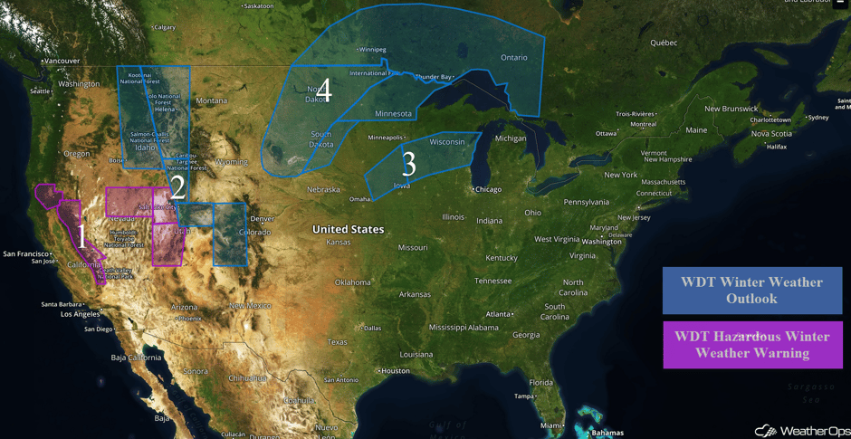 US Hazards
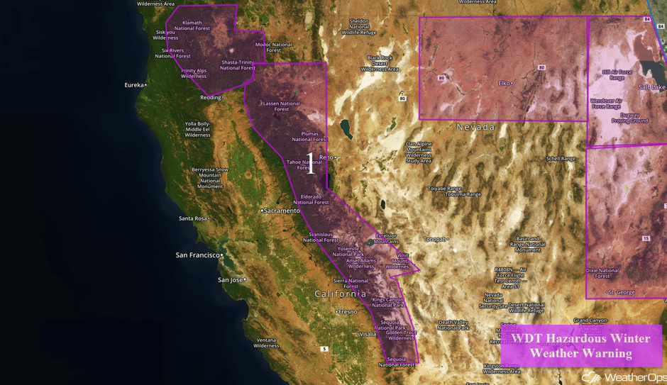
Region 1
As an area of low pressure and cold front move southward from the Pacific Northwest and into the Sierra Nevada, moderate to heavy snowfall will continue across Region 1 through Saturday. As snow continues to fall and colder air filters into the region, snow levels will also fall, dropping below 3000 feet. Snow accumulations of 5-10 inches are forecast above 3000 feet. Snow will lighten and slowly move out of the region Saturday afternoon.
Major Cities in Region: Redding, CA, Reno, NV
 Region 1
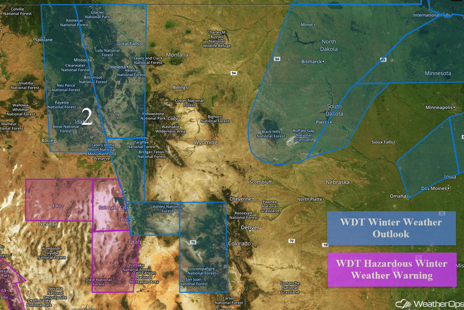
Region 2
Snow will continue to increase in coverage across Idaho and Montana Friday into Saturday across portions of Montana and Idaho. Snowfall amounts of 3-6 inches with locally higher amounts in excess of 8 inches are expected in the valleys. In the higher elevations, 5-10 inches with isolated higher amounts in excess of 15 inches are possible. Further south in portions of northeastern Nevada, 4-8 inches of snow with locally higher amounts in excess of 10 inches are forecast. In addition, wind chills will fall into the single digits by Saturday morning. Into Western Utah, snow accumulations of 10-15 inches with isolated higher amounts in excess of 21 inches are expected. Winds of 15-25 mph with gusts in excess of 30 mph will allow visibilities to fall below 2 miles and wind chills to plummet to between 0 and 10 F.
Snow is expected to develop across western Colorado by Saturday evening and continue through Sunday evening. Snowfall accumulations of 5-8 inches are likely with isolated higher amounts in excess of a foot, especially in mountainous regions. Heavy snow will reduce visibilities to less than 2 miles. Wind chills will fall between 10 and 20 F by Sunday morning.
Major Cities in Region: Boise, ID, Elko, NV, Salt Lake City, UT, Helena, MT, Great Falls, MT, Grand Junction, CO, Aspen, CO
Region 3
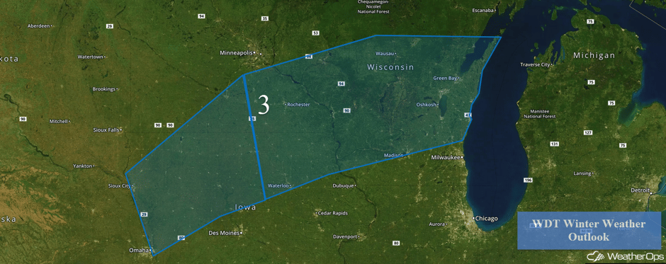
A weak area of low pressure is moving northeastward toward the Great Lakes. Along and ahead of the system, light to moderate snow has developed. These showers will increase in coverage as the morning progresses. Snowfall amounts of 2-3 inches with locally heavier amounts in excess of 6 inches are expected.
Snowing in western Wisconsin, but roads still mainly just wet at 1130 am. Thanks @news8news @WisconsinDOT #wiwx pic.twitter.com/DvwmkN5aau
— NWS La Crosse (@NWSLaCrosse) December 23, 2016
Major Cities in Region: Rochester, MN, Green Bay, WI
 Region 3
Region 4
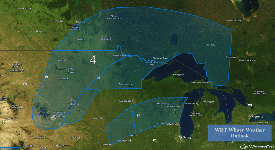
The strong area of low pressure described above will move into the Northern Plains Sunday into Monday. Snow will likely develop across the Plains early Sunday morning. Blizzard conditions are likely across the region with travel becoming difficult, if not impossible, by Sunday night. Snow accumulations of 6-14 inches with locally higher amounts are likely. Winds of 25-45 mph with gusts in excess of 50 mph will allow for visibilities of less than a quarter of a mile. Further east into Minnesota, snowfall accumulations of 3-6 inches and freezing rain accumulations of 0.1-0.3 inches are expected. Winds gusting in excess of 35 mph may limit visibilities to less than half a mile.
Major Cities in Region: Bismarck, ND, Pierre, SD, International Falls, MN
 Region 4
Excessive Rainfall Possible for Portions of California on Friday
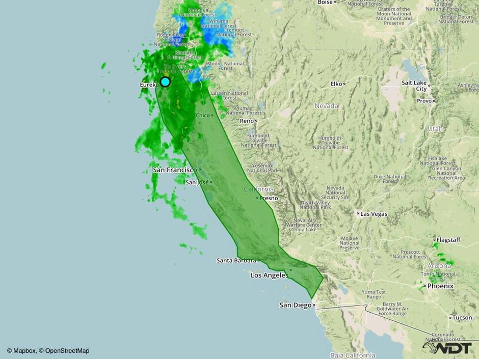
The same system bringing snow to the higher elevations of the Sierra Nevada will also bring the potential for excessive rainfall in the lower elevations of California. Rainfall amounts of 2-3 inches are expected. Given this new rainfall and runoff from mountain snow, flash flooding will be possible.
Major Cities in Region: Eureka, CA, San Francisco, CA, Los Angeles, CA
 Excessive Rainfall Risk Outline for Friday
Strong to Severe Thunderstorms Possible for Central and Southern Plains on Sunday
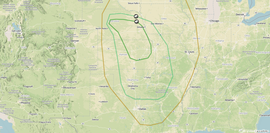
A developing area of low pressure moving across the Rockies will bring moist unstable air northward into the central and southern Plains. With the associated cold front moving into the region, isolated strong to severe thunderstorms are forecast from the eastern half of Oklahoma to southeastern Nebraska. Strong wind gusts will be the most likely hazard, but an isolated tornado cannot be ruled out.
Major Cities in Region: Grand Island, NE, Wichita, KS, Oklahoma City, OK, Tulsa, OK, Topeka, KS, Omaha, NE, Kansas City, MO, Springfield, MO
 SPC Convective Outlook for Sunday
A Look Ahead
The area of low pressure currently affecting the western US will develop into a strong surface low by Monday morning. A warm front will stretch eastward from the low over the Great Lakes. Just north of the front, a large area of sleet and freezing rain can be expected. A large shield of snow will extend westward across south central Canada back into the Dakotas. Some of this snow will be quite heavy, especially across North Dakota. Snow amounts in excess of 8 inches will be possible. In addition to the snow, high winds can be expected near the low. Winds of 25-35 mph with gusts in excess of 45 mph can be expected.
This is just a brief look at current weather hazards. We can provide you site-specific forecast information for the purpose of protecting your personnel and assets. Try a 7-day demo right away and learn how timely precision weather information can enhance your bottom line.


