


by David Moran, on Aug 31, 2018 11:15:43 AM
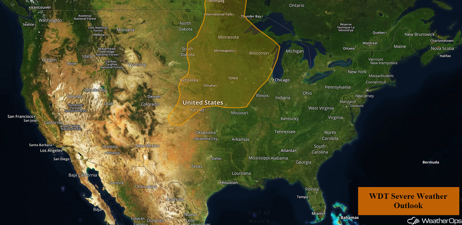
Thunderstorms are forecast across the Central and Northern Plains, as well as the Upper Midwest, on Friday as an area of low pressure moves across the region. Some of these storms will have the potential to produce heavy to excessive rainfall. There will be a risk for excessive rainfall across the Delmarva Peninsula and Chesapeake Bay.
- Thunderstorms for the Central and Northern Plains and Upper Midwest on Friday
- Excessive Rainfall Friday for the Central and Northern Plains and Upper Midwest
- Risk for Excessive Rainfall across the Delmarva Peninsula and Chesapeake Bay Friday
- Potential for Thunderstorms Saturday from the Central Plains to Great Lakes
- Excessive Rainfall from the Mid Mississippi Valley into the Central Plains Saturday
- Thunderstorms Sunday from Wisconsin into Kansas
- Potential for Excessive Rainfall from the Great Lakes into the Central Plains
- Tropical Update
US Hazards
Thunderstorms for the Central and Northern Plains and Upper Midwest on Friday
An area of low pressure moving across portions of the Plains and Upper Midwest will allow for the development of thunderstorms on Friday. The warm front will extend into Minnesota and the cold front will extend into western Kansas. Warm moist air will lie to the south of the low and its fronts. As daytime heating increases instability, storms should develop during the afternoon. Activity will be more widespread in the north where lift will be enhanced by an upper level trough. Damaging winds, large hail, and isolated tornadoes will all be potential hazards with these storms.
Major Cities in Region: Lincoln, NE, Sioux Falls, SD, Omaha, NE, Des Moines, IA, Minneapolis, MN
Thunderstorm Risk for Friday
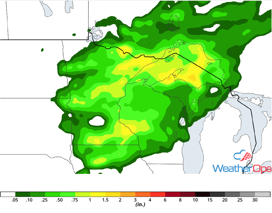
Excessive Rainfall Friday for the Central and Northern Plains and Upper Midwest
In addition to the thunderstorm risk described above, there will be a potential for heavy to excessive rainfall. Rainfall totals of 2-3 inches with locally higher amounts in excess of 4 inches are expected.
Major Cities in Region: Minneapolis, MN, Wausau, WI, Marquette, MI
Rainfall Accumulation for Friday
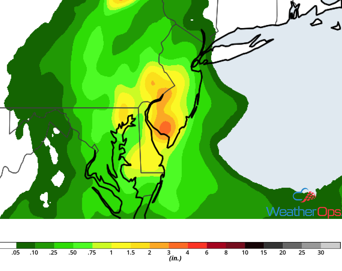
Risk for Excessive Rainfall across the Delmarva Peninsula and Chesapeake Bay Friday
Thunderstorms have continued to develop overnight along a weak frontal boundary and this activity is forecast to continue throughout the day. Rainfall accumulations of 1-3 inches with locally higher amounts in excess of 4 inches are forecast in areas that receive multiple rounds of storms.
Major Cities in Region: Dover, DE, Philadelphia, PA, Atlantic City, NJ
Rainfall Accumulation for Friday
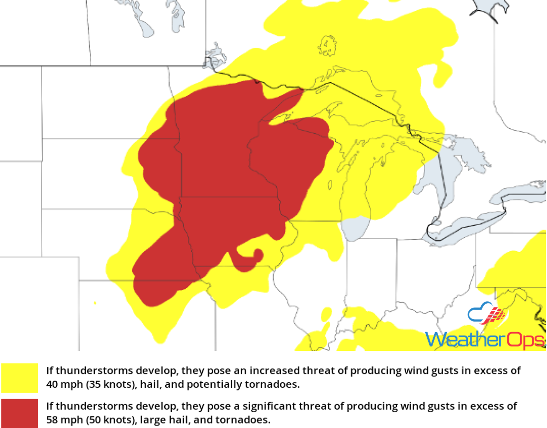
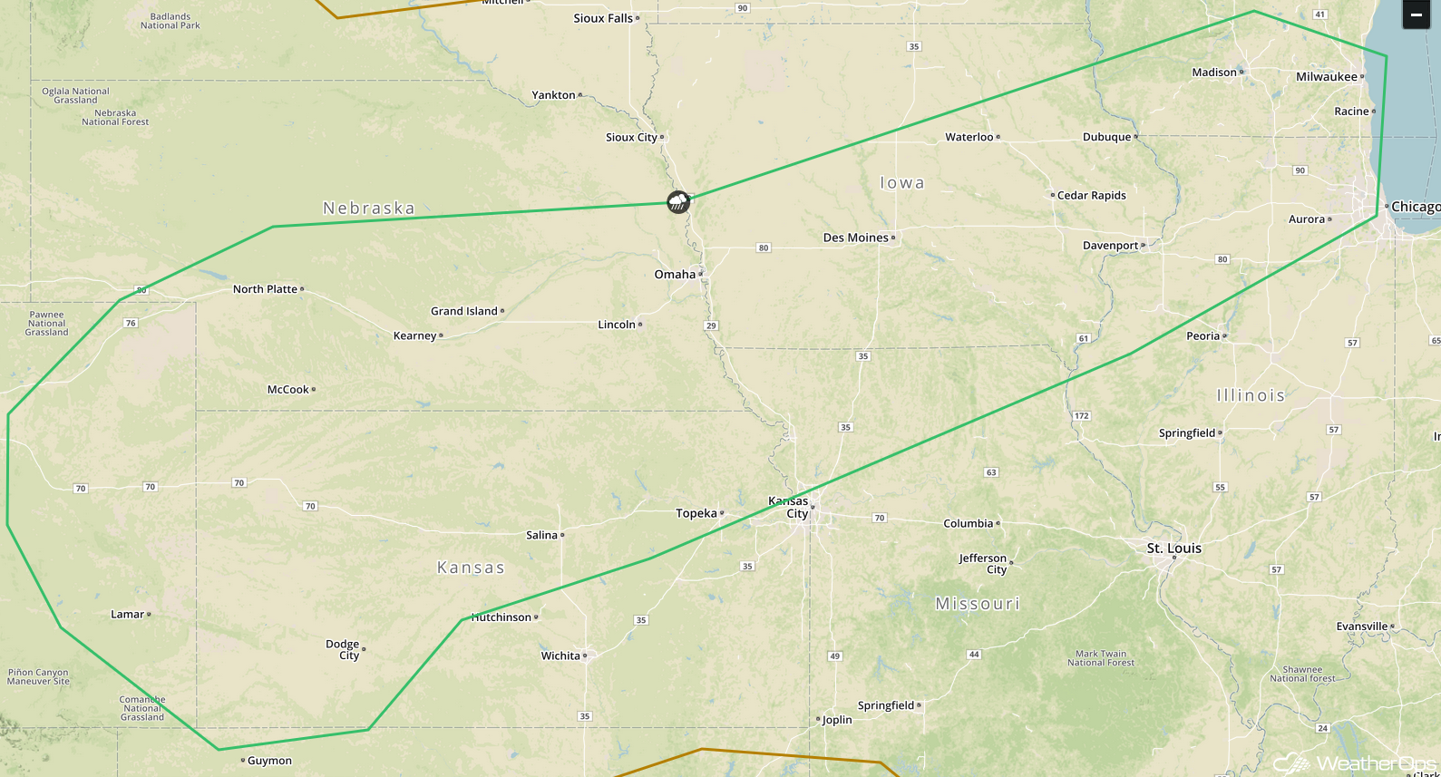
Potential for Thunderstorms Saturday from the Central Plains to Great Lakes
A front will be situated across the Plains on Saturday. As an upper level trough moves over the region during the afternoon, showers are expected to develop along and ahead of the front. Some storms will be strong to severe with damaging winds and large hail the primary hazards. Storms should weaken and dissipate with the loss of daytime heating, but a few storms could persist after dark.
Major Cities in Region: North Platte, NE, Dodge City, KS, Grand Island, NE, Topeka, KS, Omaha, NE, Des Moines, IA, Cedar Rapids, IA, Milwaukee, WI
SPC Convective Outlook for Saturday
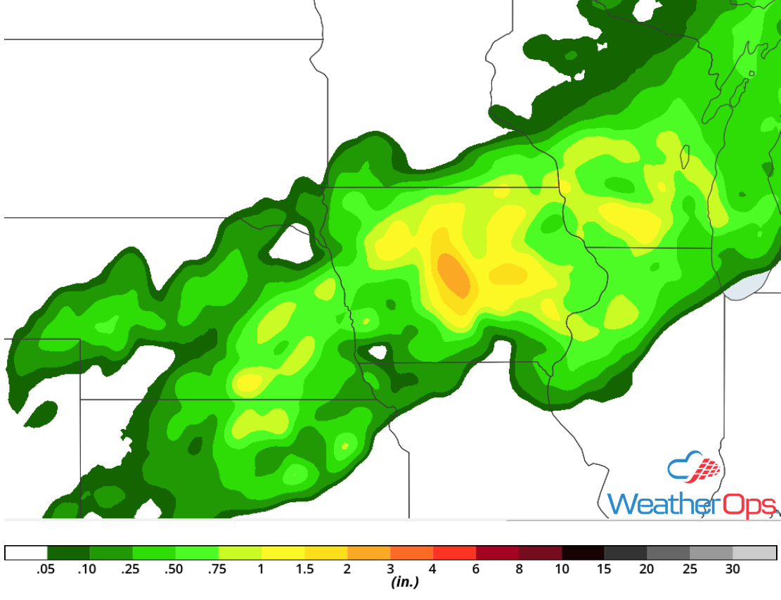
Excessive Rainfall from the Mid Mississippi Valley into the Central Plains Saturday
Thunderstorms described above will have the potential to produce heavy to excessive rainfall as moisture increases across the region. Rainfall amounts of 2-3 inches with locally higher amounts in excess of 4 inches are expected.
Major Cities in Region: Lincoln, NE, Des Moines, IA, Cedar Rapids, IA
Rainfall Accumulation for Saturday
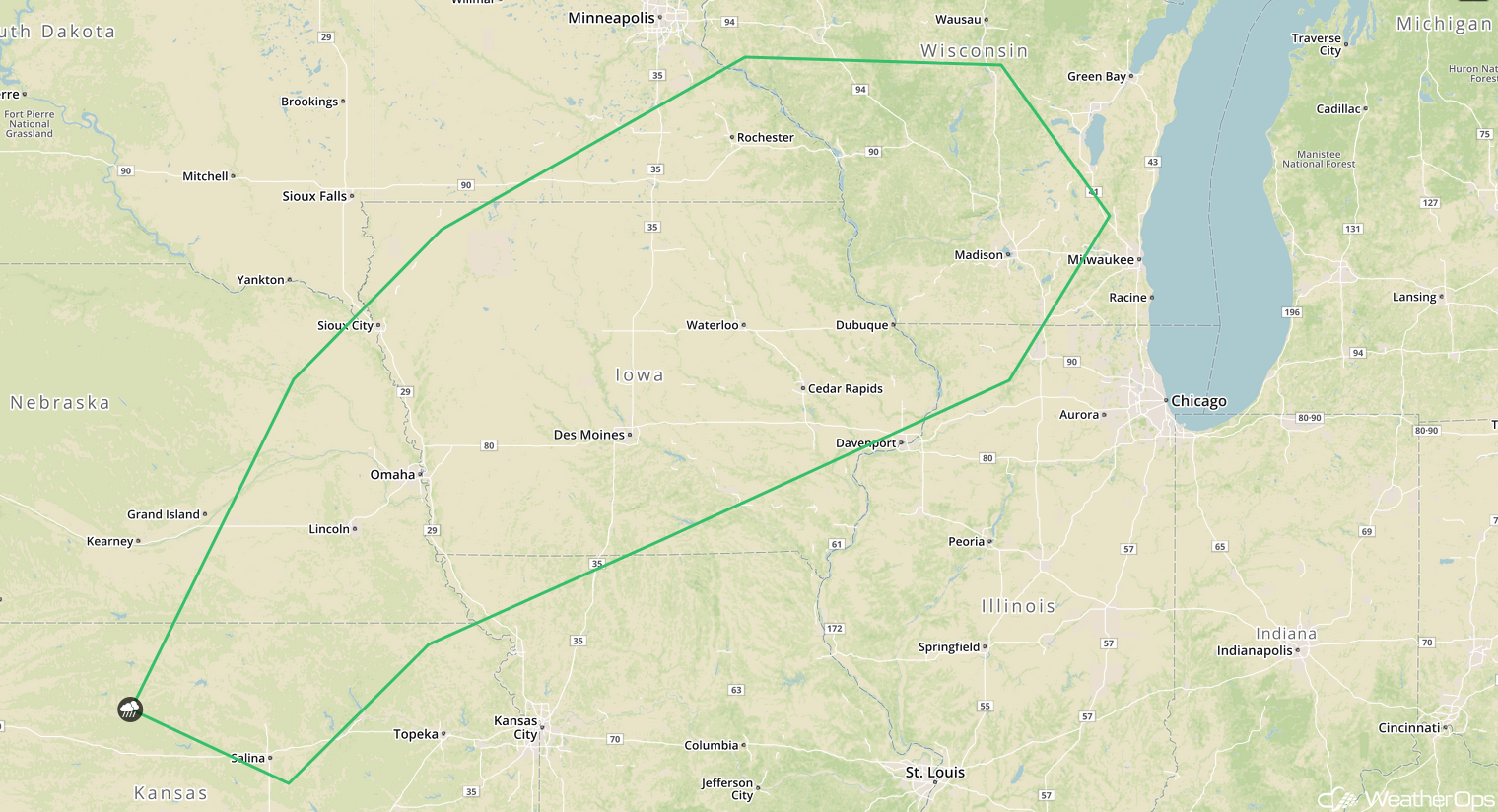
Thunderstorms Sunday from Wisconsin into Kansas
The front described above will once again be the focus for the development of thunderstorms on Sunday. A series of troughs will move across the region, providing lift for thunderstorms. Damaging winds and large hail will be the primary hazards with these storms.
Major Cities in Region: Salina, KS, Lincoln, NE, Omaha, NE, Des Moines, IA, Cedar Rapids, IA, Madison, WI
SPC Convective Outlook for Sunday
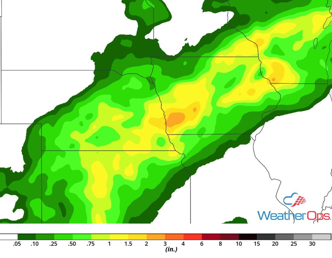
Potential for Excessive Rainfall from the Great Lakes into the Central Plains
The thunderstorm activity above will also pose a risk for excessive rainfall. Rainfall amounts will range 1-3 inches with locally higher amounts in excess of 4 inches.
Major Cities in Region: Lincoln, NE, Omaha, NE, Des Moines, IA, Cedar Rapids, IA, Madison, WI
Rainfall Accumulation for Sunday
Tropical Update
Potential Tropical Cyclone Six (green oval) is 135 miles southeast of the Cabo Verde Islands and is moving west-northwestward at 13 mph. This motion is expected to continue with an increase in forward speed for the next three to four days. On the forecast track, the disturbance is expected to move near or over the southern Cabo Verde Islands today and tonight. Sustained winds are at 35 mph with higher gusts. This disturbance is expected to become a tropical storm later today or on Saturday.
Disorganized cloudiness and showers (red oval) from Hispaniola eastward to the Leeward Islands are associated with a tropical wave interacting with an upper level trough. This activity is forecast to spread westward to west-northwestward, enhancing rainfall across Hispaniola, the Bahamas, the Turks and Caicos Islands, and Florida into early next week. Strong upper level winds will prevent any development of this system, but environmental conditions could become more favorable when the system reaches the eastern Gulf of Mexico during the early to middle part of next week.
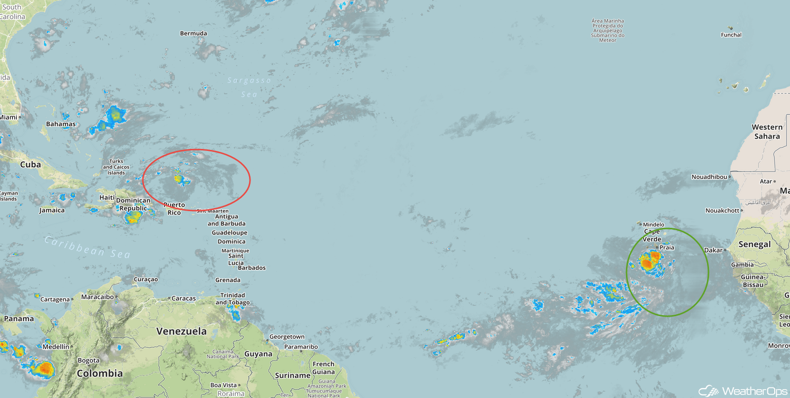
Enhanced Infrared Tropical Satellite
A Look Ahead
Thunderstorms are forecast to develop across the Central Plains and Upper Midwest on Labor Day as an area of low pressure moves northeastward. Some of this activity will spread into the western Great Lakes on Tuesday. By Wednesday, showers and thunderstorms will decrease in intensity, but will extend from the Plains into the Great Lakes. A few thunderstorms may develop across the Central Plains and Midwest on Thursday.
