


by David Moran, on Aug 3, 2018 11:13:37 AM
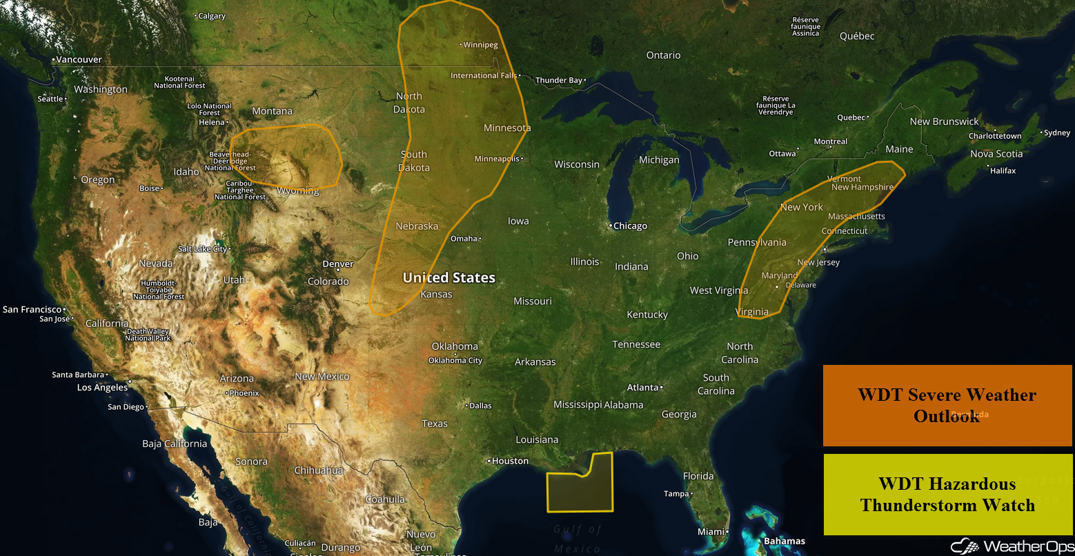
Thunderstorms will continue for portions of the central Gulf of Mexico through early Friday afternoon as an area of low pressure remains in place over the region. An upper level trough will allow for the development of thunderstorms from the Mid Atlantic into New England. This trough will bring a risk for excessive rainfall from the Southeast into the Northeast. A cold front will be the focus for thunderstorm development across the Central Plains. Thunderstorms may develop across the Northern Rockies as a disturbance moves across the region.
- Continued Thunderstorms for the Central Gulf of Mexico through Early Friday Afternoon
- Thunderstorms Friday from the Mid Atlantic into New England
- Excessive Rainfall from the Southeast to the Northeast on Friday
- Risk for Thunderstorms Friday across the Central Plains
- Thunderstorm Potential for the Northern Rockies on Friday
- Thunderstorms Saturday for the Central Plains
- Potential for Thunderstorms across the Central High Plains into the Great Lakes on Sunday
US Hazards
Continued Thunderstorms for the Central Gulf of Mexico through Early Friday Afternoon
Thunderstorms will continue across the central Gulf of Mexico through early Friday afternoon as an area of low pressure remains in place over the region. With strong instability and ample moisture in place, additional thunderstorms are expected. Some of these storms could become strong with wind gusts in excess of 40 knots, frequent lightning, and heavy rain potential hazards.
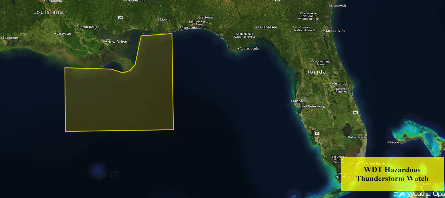
WDT Hazardous Thunderstorm Watch
Thunderstorms Friday from the Mid Atlantic into New England
The upper level trough over the Eastern US will move little on Friday. Southerly flow will continue to pump ample moisture northward. Although widespread cloud cover and ongoing thunderstorm activity will limit instability across much of the Mid Atlantic and northward, instability and shear should be sufficient for the development of thunderstorms. Some of this activity could become strong to severe in nature with damaging winds the primary hazard, but an isolated tornado or two cannot be ruled out.
Major Cities in Region: Washington, DC, Baltimore, MD, Philadelphia, PA, Albany, NY
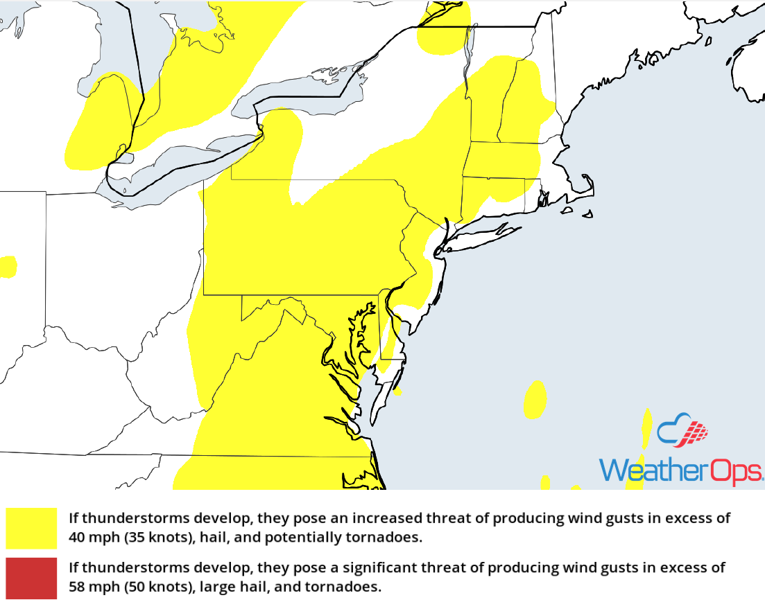
Thunderstorm Risk for Friday
Excessive Rainfall from the Southeast to the Northeast on Friday
In addition to the risk for thunderstorms described above, there will be a potential for excessive rainfall. Rainfall accumulations of 1-2 inches with locally heavier amounts in excess of 3 inches are expected. With heavy rainfall that has already occurred, there will be a potential for widespread flooding and excessive runoff.
Major Cities in Region: Blacksburg, VA, Raleigh, NC, Washington, DC, Baltimore, MD, Philadelphia, PA, Albany, NY
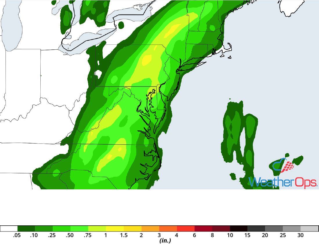
Rainfall Accumulation for Friday
Risk for Thunderstorms Friday across the Central Plains
An area of low pressure in the Canadian Prairies will slowly track eastward on Friday. To the south of this system, strong instability, plentiful low level moisture, and strong wind shear will be in place. This will result in the development of showers and thunderstorms during the afternoon and evening. Some of these storms will become strong to severe as they move eastward. Large hail and damaging winds will be the primary hazards with these storms. Later in the evening, these thunderstorms will evolve into clusters, with the threat transitioning to primarily damaging winds.
Major Cities in Region: Goodland, KS, North Platte, NE, Pierre, SD, Grand Forks, ND, Fargo, ND, Sioux Falls, SD
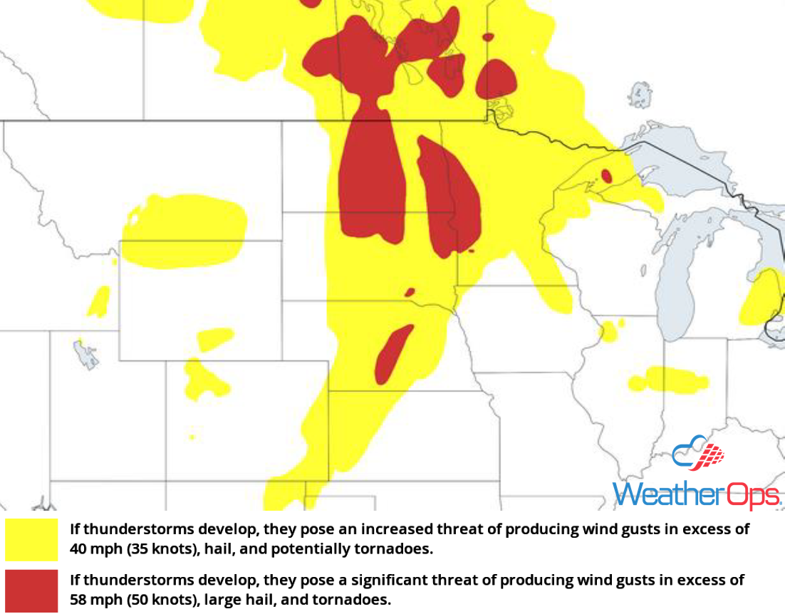
Thunderstorm Risk for Friday
Thunderstorm Potential for the Northern Rockies on Friday
A disturbance will be moving eastward across the Rockies today. With strong wind shear in place across the region and ample lift, isolated to widely scattered showers and thunderstorms are forecast to develop across the higher terrain of the Northern Rockies this afternoon. Large hail and damaging winds will be the primary hazards with the stronger storms.
Major Cities in Region: Billings, MT, Gillette, WY
Thunderstorm Risk for Friday
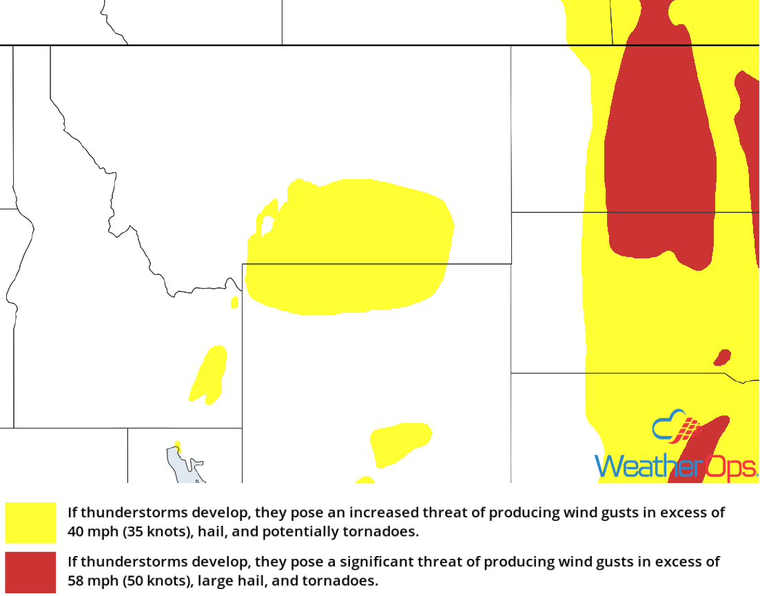
Thunderstorms Saturday for the Central Plains
Ongoing morning thunderstorm activity is expected across the Central and Northern Plains, as well as the Upper Midwest. Some of this activity will bring a threat for damaging winds and small hail. Going into the afternoon, a slow moving cold front and associated area of low pressure will track eastward across the Plains. Ahead of this area of low pressure, instability and wind shear will increase, promoting additional shower and thunderstorm activity. Damaging winds, large hail, and isolated tornadoes will be potential hazards with these storms.
Major Cities in Region: Scottsbluff, NE, North Platte, NE, Pierre, SD, Grand Forks, ND, Fargo, ND, Sioux Falls, SD, International Falls, MN, Minneapolis, MN, Rochester, MN, Duluth, MN, Wausau, WI, Marquette, MI
SPC Convective Outlook for Saturday
Potential for Thunderstorms across the Central High Plains into the Great Lakes on Sunday
Ongoing morning thunderstorm activity is forecast to persist across portions of the Upper Midwest on Sunday, bringing a risk for damaging winds and small hail. By the afternoon, a weak slow moving cold front will make its way into the Central Plains and Great Lakes. To the south of this front, warm moist air will lift northward. As daytime heating increases, instability will build. With weak forcing and strong wind shear along the front, additional thunderstorms are forecast later in the afternoon; some storms becoming strong to severe. Damaging winds and small hail will be the primary hazards with the stronger storms.
Major Cities in Region: Denver. CO, Cheyenne, WY, Scottsbluff, NE, North Platte, NE, Norfolk, NE, Sioux City, IA, Rochester, MN, La Crosse, WI, Wausau, WI, Green Bay, WI, Traverse City, MI, Sault Ste. Marie, MI
SPC Convective Outlook for Sunday
A Look Ahead
Showers and thunderstorms will continue across the Great Lakes on Monday as the cold front described above continues to move eastward. By Tuesday, thunderstorms will extend from the Northeast into the Ohio River Valley. As the cold front continues eastward on Wednesday, showers will extend from the Northeast to the Mid Atlantic. Further west, showers may develop from the Southern Plains into the Tennessee Valley. Thunderstorms are forecast across portions of the Southeast on Thursday.
