National Weather Summary for Friday, August 12, 2016
by David Moran, on Aug 12, 2016 12:18:22 PM
Thunderstorms will be possible for portions of the eastern Great Lakes into the Northeast on Friday as a warm front lifts north over the region. Showers and thunderstorms will allow for the potential for heavy rain across the Upper Mississippi Valley and Southern Great Lakes. Across the High Plains, upslope flow will allow for the risk for thunderstorms for portions of the Colorado High Plains. Further to the east, thunderstorms will be possible across portions of the Southern Plains ahead of a cold front. Heavy rain will continue along the Gulf Coast and into the Lower Mississippi Valley as an area of low pressure moves through the region. As moisture moves northward on Saturday, heavy rain will be possible across the Mississippi and Ohio Valleys. As the area of low pressure continues to move to the northwest on Saturday, heavy rain will be possible from Western Louisiana into Central Texas.
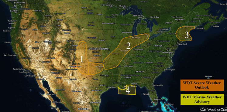
US Hazards
Region 1
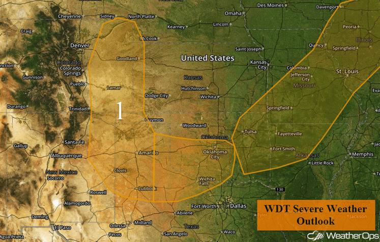
An area of low pressure extends across Region 1 today with strong surface heating occurring. With plentiful moisture, some instability is forecast to develop into the afternoon hours, leading to isolated thunderstorm clusters. Large hail and strong wind gusts due to localized microbursts will be possible with thunderstorms across the region.
Major Cities in Region: Goodland, KS, Amarillo, TX, Lubbock, TX, Oklahoma City, OK
Region 1
Region 2
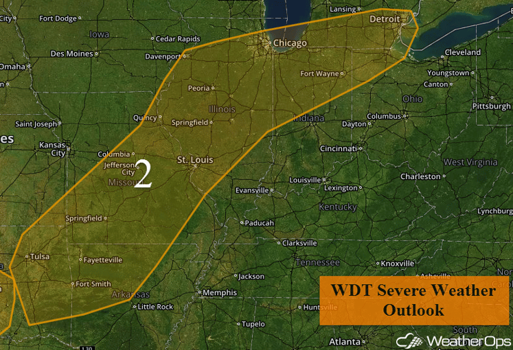
A marginal risk for thunderstorms exists across Region 2 ahead of a cold front pushing to the east and southeast. As instability builds due to daytime heating and increasing moisture, thunderstorms will have the potential to develop with localized strong wind gusts as the main severe weather threat.
Update 1:36pm: Tornado Warned storm SW of Grand Rapids, MI
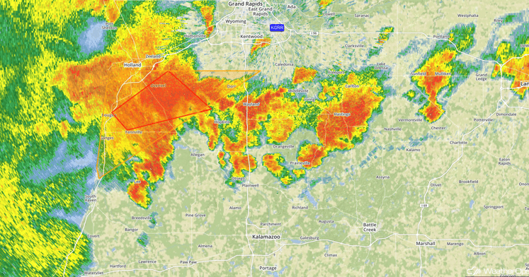
Grand Rapids, MI Radar 1:36pm CDT
Major Cities in Region: Tulsa, OK, Fort Smith, AR, St. Louis, MO, Chicago, IL, Detroit, MI
Region 2
Region 3
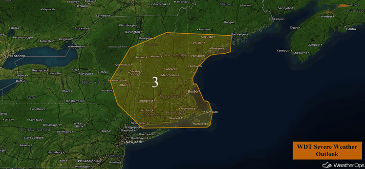
A low level trough is forecast to move through the region over the course of the day, leading to the potential for the development of thunderstorms. The main hazard with any thunderstorms that develop will be strong winds.
Major Cities in Region: Augusta, ME, Concord, NH, Albany, NY, Boston, MA
Region 3
Region 4
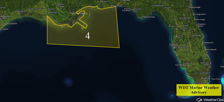
An area of low pressure slowly moving westward along the Central Gulf Coast will continue to affect the weather over the region for the next couple of days. Winds may increase to 30-40 miles per hour with higher gusts through Friday afternoon. Periods of showers and thunderstorms are expected, with increased winds and seas as well. This low should weaken during the day on Friday, which will also decrease winds over the water.
Region 4
Excessive Rainfall Possible for Upper Mississippi Valley and Southern Great Lakes on Wednesday
Ongoing showers and thunderstorms during the morning hours will persist through the early morning and dissipate during the late morning hours. Additional development of rain showers and heavy thunderstorms is expected during the afternoon and evening hours across the threat region, and will bring along the potential for excessive rainfall. Total rainfall accumulations of 1-3 inches will be likely, with locally higher amounts in excess of 4 inches possible.
Major Cities in Region: Dayton, OH, Evansville, IN, Paducah, KY
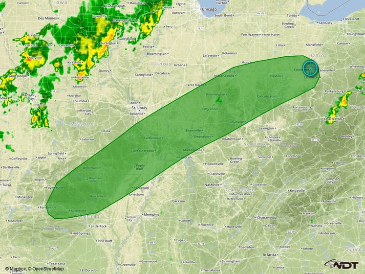
Excessive Rainfall Risk Outline for Friday
Excessive Rainfall Possible for Gulf Coast and Lower Mississippi Valley on Friday
There will be a continued threat for extreme rainfall and flash flooding across much of Louisiana and southwest Mississippi as an area of low pressure slowly moves through the region. Very similar to days before, showers and thunderstorms will be scattered to widespread throughout the day with very heavy rainfall possible within this activity. Additional rainfall across the threat area of 2-5 inches with locally heavier amounts in excess of 10 inches will be possible.
Update 1:47pm: Below is an image of Storm Total Precipitation near New Orleans. Red areas indicate near 10 inches of rain.
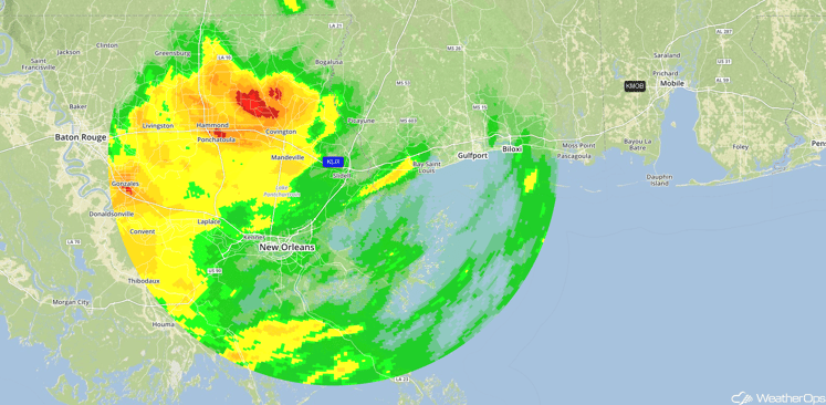
Storm Total Precipitation Louisiana 8/12/16 1:47pm
Major Cities in Region: Lake Charles, LA, Baton Rouge, LA, New Orleans, LA
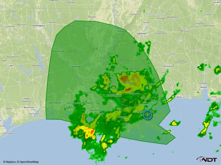
Excessive Rainfall Risk Outline for Friday
Excessive Rainfall Possible Saturday Across the Mississippi and Ohio Valleys
Widespread showers and thunderstorms are expected to develop along a slow moving frontal boundary draped across the Ohio and Mississippi Valleys on Saturday. This activity is expected to be persistent in nature with very little storm motion. Due to the slow moving nature and ample moisture across the area, excessive rainfall leading to flooding will be a concern within the threat region. Rainfall accumulations of 1-3 inches will be likely with locally higher amounts in excess of 4 inches possible within the heavier storms.
Major Cities in Region: Cincinnati, OH, Evansville, IN, Paducah, KY
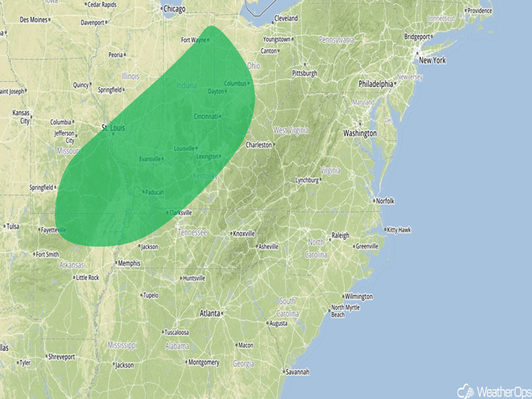
Excessive Rainfall Risk Outline for Saturday
Excessive Rainfall Possible for Portions of Central Texas into Western Louisiana
The threat for excessive rainfall will shift westward on Saturday as an area of low pressure continues to slowly track towards the northwest. This low is expected to produce copious amounts of rainfall across the threat region, especially across Louisiana, during much of the day. Rainfall accumulations of 2-4 inches with locally higher amounts of 6 inches will be possible through the overnight hours, especially across the eastern portions of the outlook area.
Major Cities in Region: Baton Rouge, LA, Lake Charles, LA, Shreveport, LA, Dallas, TX, Waco, TX
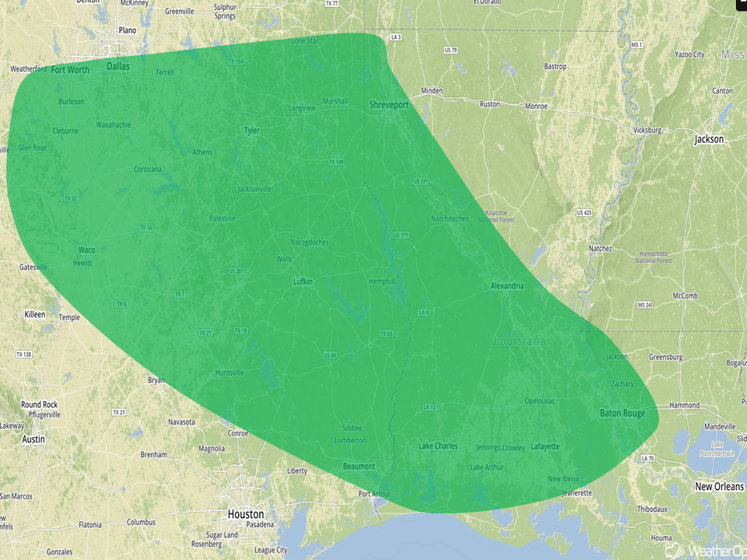
Excessive Rainfall Risk Outline for Saturday
Excessive Rainfall Possible from the Mississippi Valley into the Southern Plains on Sunday
There will be a chance for heavy rain leading to flooding across the Mid Mississippi Valley into east Texas on Sunday. An upper level low will begin to track northeastward during the day and will interact with a stalled frontal boundary draped across the region. Due to the extremely high moisture associated with this low, widespread showers and thunderstorms will develop in the vicinity of the stalled boundary. This activity will persist throughout the day and evening, with total rainfall accumulations of 1-3 inches with locally heavier amounts in excess of 4 inches possible.
Major Cities in Region: Memphis, TN, Little Rock, AR, Shreveport, LA, Waco, TX, Houston, TX
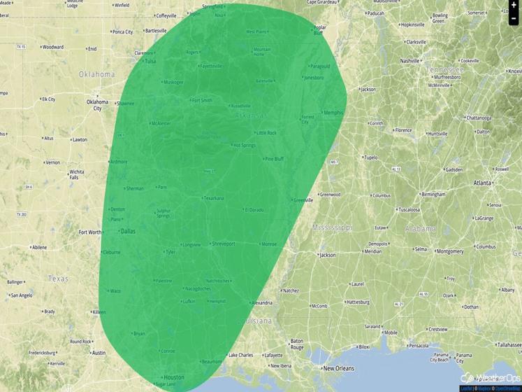
Excessive Rainfall Risk Outline for Sunday
This is just a brief look at current weather hazards. We can provide you site-specific forecast information for the purpose of protecting your personnel and assets. Try a 7-day demo right away and learn how timely precision weather information can enhance your bottom line.


