


by David Moran, on Apr 6, 2018 11:19:53 AM
Snow will continue for portions of the Northern Rockies and Plains through Friday evening as an area of low pressure moves across the region. Snow is forecast from the Ohio Valley to the Mid Atlantic Friday evening through Sunday morning as an area of low pressure tracks eastward. Thunderstorms will continue for the Southern Plains into the Lower Mississippi Valley ahead of a cold front. Thunderstorms across the Lower Mississippi Valley may allow for a risk of excessive rainfall.
- Snow Continuing for the Northern Rockies and Plains through Friday Evening
- Snow Friday Evening through Early Sunday Morning from the Ohio Valley to the Mid Atlantic
- Thunderstorms from the Southern Plains to Lower Mississippi Valley Friday
- Excessive Rainfall Friday for the Lower Mississippi Valley
- Excessive Rainfall for Northern California through Saturday
- Potential for Thunderstorms Saturday across the Southeast
- Snow for the Northern Plains and Midwest Sunday into Monday
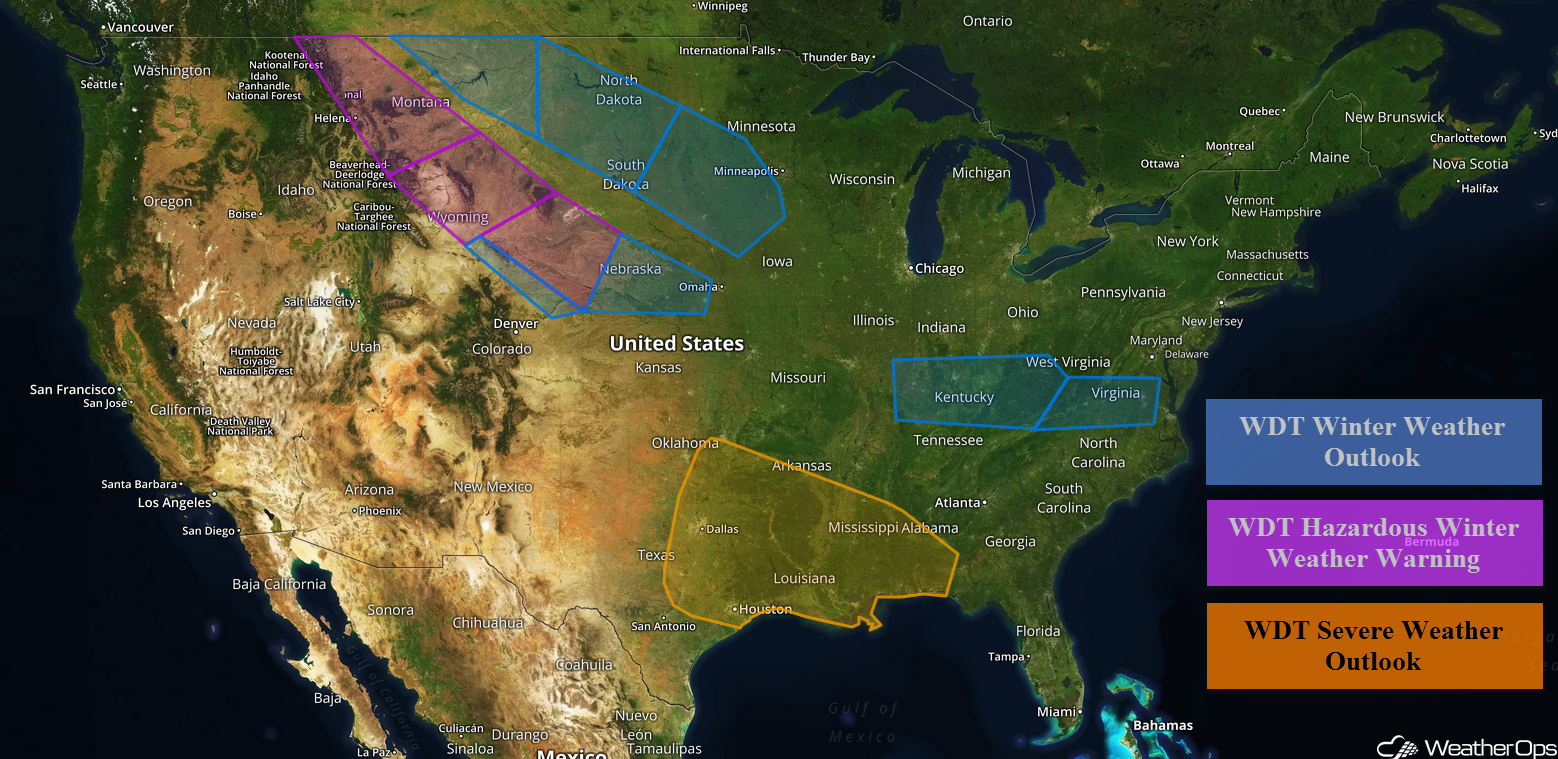 US Hazards

Snow Continuing for the Northern Rockies and Plains through Friday Evening
Moderate to locally heavy snow will continue Friday across the Northern Rockies and Plains as an area of low pressure moves through the region.
- Western and Southern Montana: Snow accumulations of 4-6 inches with locally higher amounts are forecast in excess of 8 inches in the lower elevations. For the higher elevations, 6-10 inches with locally higher amounts in excess of a foot are expected.
- Southern Montana through Northeast Wyoming: Accumulations will range 3-6 inches with locally higher amounts in excess of 8 inches for the lower elevations. In the higher elevations, 6-10 inches with locally higher amounts in excess of a foot are forecast.
- Southern Wyoming, Southwestern South Dakota and Western Nebraska: Accumulations of 5-8 inches with locally higher amounts in excess of 9 inches are forecast in the lower elevations. For the higher elevations, 6-10 inches with locally higher amounts in excess of a foot are expected. Winds will gust 25-30 mph, allowing for blowing snow and low visibilities.
- Southeastern Wyoming to Extreme Northeastern Colorado: Accumulations of 2-4 inches with locally higher amounts in excess of 5 inches for the lower elevations are forecast. In the higher elevations, 4-8 inches are expected. Winds will gust 20-30 mph at times.
- Central and Western Nebraska: Accumulations of 2-4 inches. Winds gusting to 35 mph.
Major Cities in Region: Helena, MT, Great Falls, MT, Billings, MT, Cheyenne, WY, North Platte, NE, Lincoln, NE
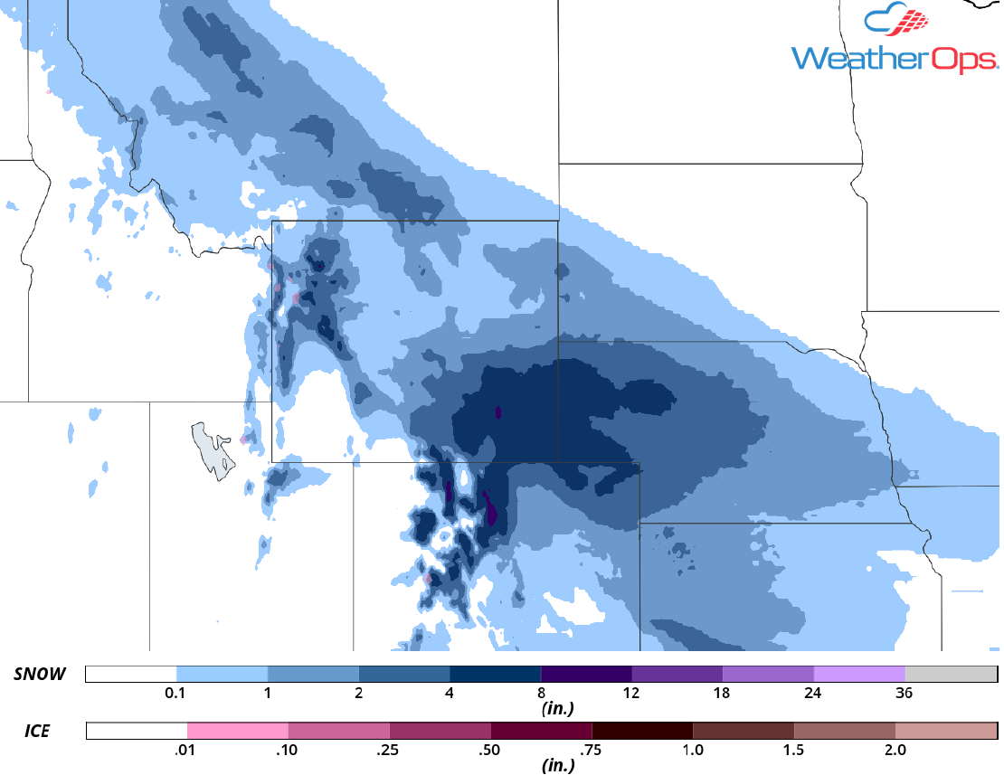 Snow Accumulation for Friday
Snow Friday Evening through Early Sunday Morning from the Ohio Valley to the Mid Atlantic
As an area of low pressure slowly moves eastward, snow is forecast from the Ohio Valley into the Mid Atlantic Friday afternoon through Sunday morning.
- Western Kentucky into Western West Virginia: Snow accumulations of 2-4 inches with locally higher amounts of 5 inches.
- Southeastern West Virginia into Virginia: Accumulations of 1-3 inches in the lower elevations and 2-5 inches in the higher elevations.
Major Cities in Region: Evansville, IN, Louisville, KY, Charleston, WV, Richmond, VA
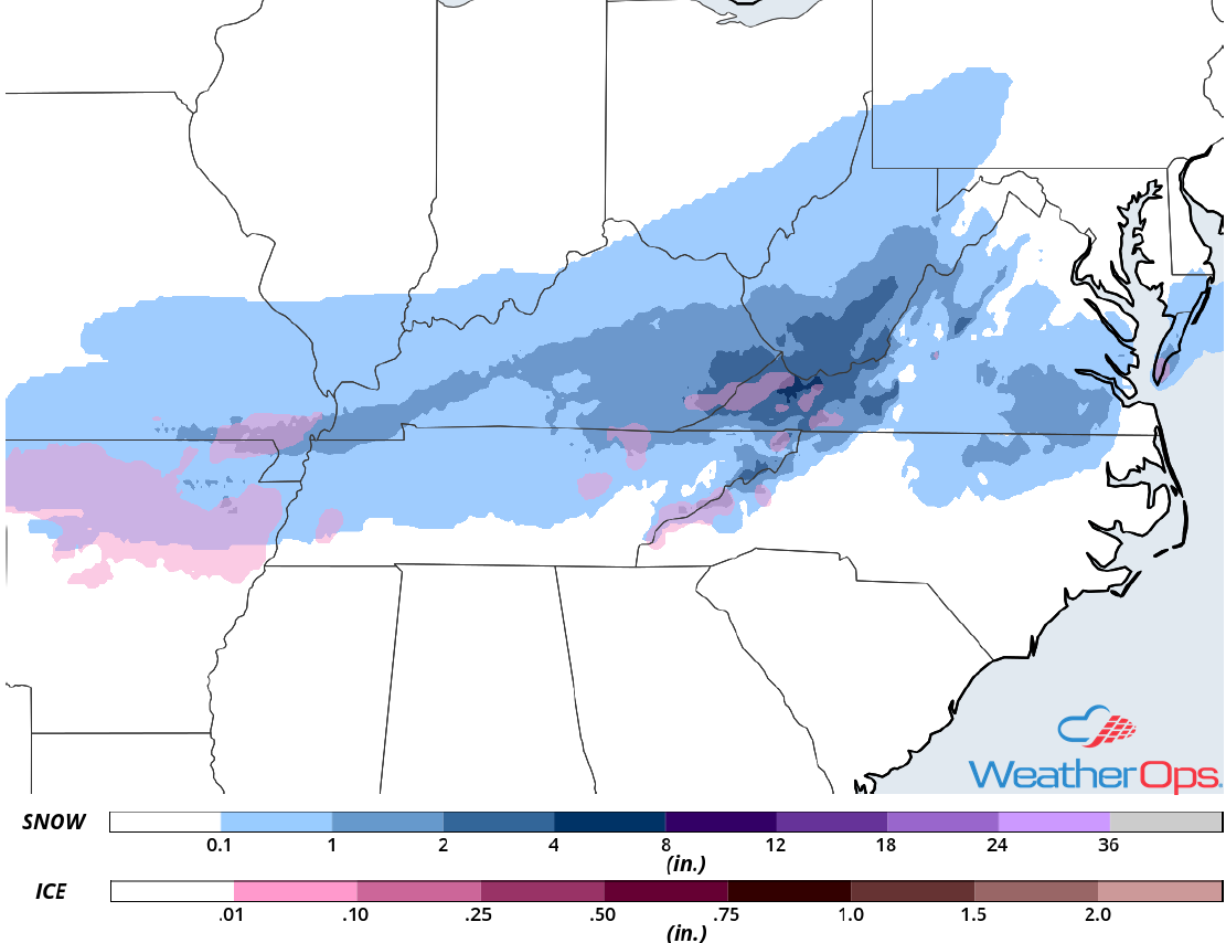 Ice and Snow Accumulation for Friday through Sunday
Thunderstorms from the Southern Plains to Lower Mississippi Valley Friday
There will be a risk for strong to severe thunderstorms from the Southern Plains into the Lower Mississippi Valley on Friday. Thunderstorms have developed across the region and will pose a threat for strong winds and hail. Activity will increase throughout the day ahead of a cold front. Damaging winds will be the primary hazard, but there will also be a risk for hail mainly over North Central Texas. A line of storms will track southward toward the Gulf Coast during the overnight hours, with damaging winds and isolated tornadoes the primary hazards.
Major Cities in Region: Austin, TX, Dallas, TX, Houston, TX, Fort Smith, AR, Shreveport, LA, Little Rock, AR, Baton Rouge, LA, New Orleans, LA, Jackson, MS, Mobile, AL
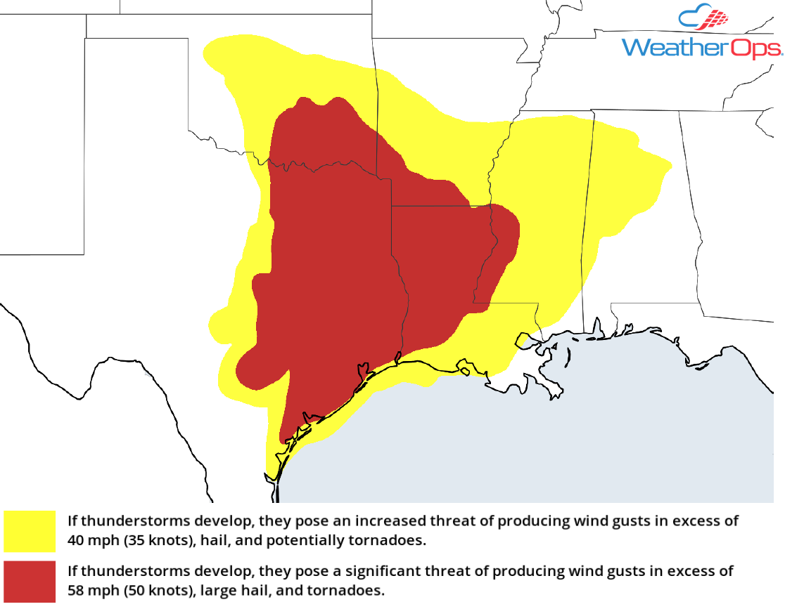 Thunderstorm Potential for Friday
Excessive Rainfall Friday for the Lower Mississippi Valley
There will be a risk for excessive rainfall and flash flooding across the Lower Mississippi Valley in association with the thunderstorms described above. Rainfall amounts will range 1-3 inches with locally higher amounts in excess of 5 inches, leading to the potential for flash flooding.
Major Citlies in Region: Tyler, TX, Shreveport, LA, Alexandria, LA, Jackson, MS
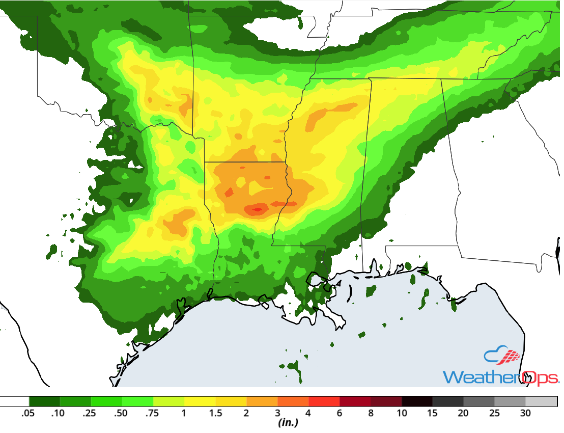 Rainfall Accumulation for Friday
Excessive Rainfall for Northern California through Saturday
Widespread rainfall will continue across Northern California through Saturday as moisture continues to stream into the region. Rainfall accumulations of 2-4 inches with isolated higher amounts in excess of 7 inches are expected. Flooding and mudslides are likely. In addition, melting snow may add to the flooding potential.
Major Cities in Region: Eureka, CA, San Francisco, CA, Sacramento, CA
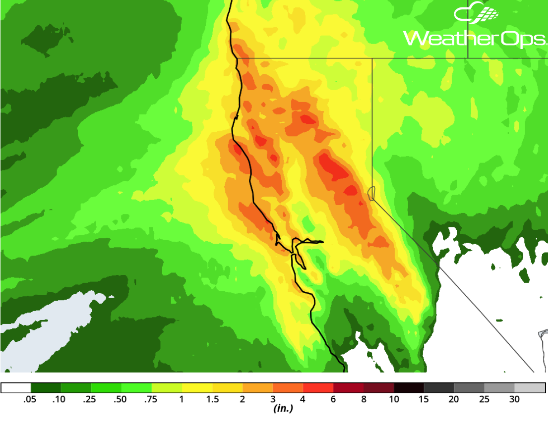 Rainfall Accumulation for Friday and Saturday
Potential for Thunderstorms Saturday across the Southeast
Strong to severe thunderstorms may develop across portions of the Southeast on Saturday as an area of low pressure and associated cold front continues to move eastward. By the afternoon, the potential will be highest over Southern Georgia and Florida. Scattered to widespread thunderstorms are forecast through the evening. Damaging winds and an isolated tornado will be the primary hazards with these storms.
Major Cities in Region: Tallahassee, FL, Savannah, GA, Charleston, SC, Wilmington, NC
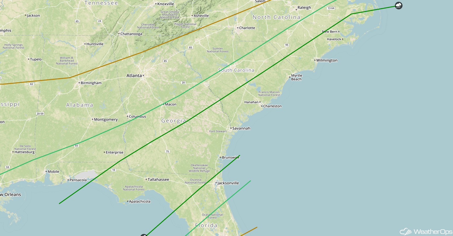 SPC Convective Outlook for Saturday
Snow for the Northern Plains and Midwest Sunday into Monday
Another round of snow is expected across the Northern Plains and Midwest Sunday into Monday as an area of low pressure develops across the region. Precipitation will begin as rain before transitioning to a wintry mix and finally snow. Snow accumulations of 3-6 inches with locally higher amounts in excess of 8 inches are expected. In addition, freezing rain accumulations up to 0.10 inch are forecast.
Major Cities in Region: Minot, ND, Bismarck, ND, Sioux Falls, SD, Minneapolis, MN
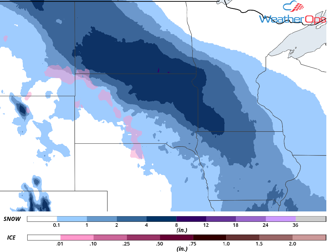 Snow Accumulation for Sunday and Monday
A Look Ahead
Snow may develop across the Northern Plains Wednesday into Thursday as an area of low pressure develops. Potential accumulations are uncertain at the time.
This is just a brief look at current weather hazards. We can provide you site-specific weather forecast information for the purpose of protecting your personnel and assets and to assess your weather risk. Try a 7-day demo right away and learn how timely precision weather information can enhance your bottom line.
