by Daphne Thompson, on Mar 14, 2017 10:24:15 AM
A storm system centered near the mouth of the Chesapeake will head northeastward while strengthening rapidly today. Heavy snow and strong winds are already in place across much of the Northeast, and the snow and wind will persist throughout the day today as the storm heads up the coast.
 US Hazards

Region1
A powerful Nor'easter will track northward along the US East Coast on Tuesday. Associated heavy snowfall began on Tuesday morning. By late morning, and into the afternoon and evening hours, snowfall rates will become quite intense and potentially be greater than 1-2 inches per hour for several hours. Accumulating snow will continue on Wednesday, but snowfall rates will not be as high as on Tuesday. Widespread snowfall accumulations through Wednesday of 12-20 inches are expected across Region 1. Locally heavier amounts in excess of 2 feet will be possible as well. Breezy winds of 10-20 mph may allow for some areas of blowing snow across the region. Significant travel disruptions can be expected, especially over the latter half of Tuesday into Wednesday.
 Region 1
Region 2
A reinforcing surge of cooler air will move offshore and into the central Gulf tonight in the wake of today's low pressure center. Strong northerly winds and moderate to locally rough seas of 6 to 9 feet can be expected through Tuesday morning as a result. Winds will be from the north at 22 to 28 knots with gusts in excess of 35 knots.
 Region 2
Significant Snowfall Possible Tuesday for the Northeast
A strong low pressure system is just offshore this Tuesday morning, impacting much of the Northeast with heavy snowfall. This system will track to the north-northeast along the coast throughout the day bringing heavy snowfall, gusty winds, and reduced visibility to the region leading to blizzard like conditions in some locations. Snowfall rates of 1 to 3 inches per hour will be possible with the available moisture with this Nor’easter. There is the potential for thundersnow at times within the heaviest snow bands. Total accumulations of 12 to 18 inches will be possible over the area, with locally heavier amounts between 18 to 24 inches dependent upon where the heaviest snow banding occurs. As a result, major impacts to the Northeast remains in the forecast on Tuesday.
 Significant Snowfall for Tuesday
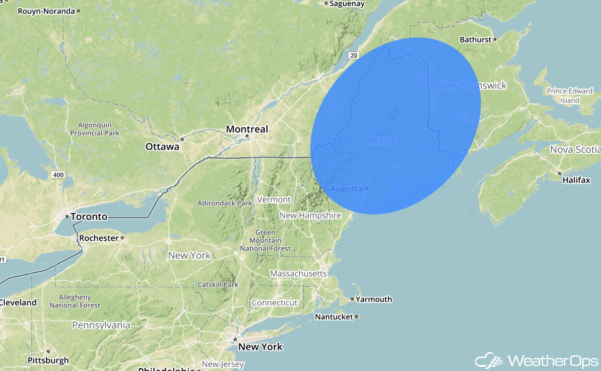
Significant Snowfall Possible in Maine on Wednesday
Into Wednesday, as the strong Nor’easter continues to track to the north-northeast into eastern Canada, heavy snowfall is forecast to continue across portions of Maine. With the gusty winds, blowing snow from Tuesday, along with the additional snowfall, some blizzard like conditions will be possible. Additional accumulations across the region of 6 to 8 inches are forecast with locally heavier amounts between 8 to 12 inches within the heavier snow bands. Snowfall is forecast over Maine for the morning and into the afternoon with the snow beginning to taper off into the evening as the low begins lifting completely out of the region.
 Significant Snowfall for Wednesday
A Look Ahead
By the end of the weekend, moderate to heavy snowfall may be possible in the Northeast as the low pressure system further develops and moves offshore. However, similar to the potential weather threat for snow on Saturday, overall confidence in the location of the low pressure system is low at this time. WeatherOps will continue to monitor the development and placement of this low pressure system in the upcoming days. Into Monday, the main feature is a developing low pressure system across the Central Plains. Some thunderstorms may be possible into the afternoon however the exact intensity and thunderstorm potential remains uncertain at this time.
This is just a brief look at current weather hazards. We can provide you site-specific weather forecast information for the purpose of protecting your personnel and assets and to assess your weather risk. Try a 7-day demo right away and learn how timely precision weather information can enhance your bottom line.