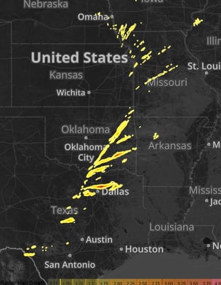
Daily Hail Report with TX in the lead
by Marcus Hicks, on Mar 24, 2016 9:52:37 AM
Environmental conditions today will be favorable for severe storms, with the greatest threat being in the Tennessee Valley south into the Gulf States during the afternoon hours into the evening. Late night storm formation will also be possible in the Southeast with storms becoming strong or severe during the late evening into overnight hours. Multiple threats will be possible from Tennessee southward into the Gulf Coast high winds, hail and tornadoes, damaging wind appears to be the main threat for the Ohio Valley.
Severe storms occured as forecasted and plowed through TX, OK, MO and AR last night 3/23 dropping hail up 4” in TX and hail calculated at 3” in areas of OK and 1.5” in MO, IA, NE and IL. Everything really is bigger in TX, right?

The contours on our hail maps are produced from proprietary hail algorithms utilizing high resolution dual-pol radar data at all elevation scans. Other map providers may only utilize the lowest elevation scan or free, lower resolution Level 3 data which results in less accurate, low resolution heat map type displays.
Weather Decision Technologies is at the forefront of severe weather data and is the leading weather data provider. With the latest in-house dual-pol hail algorithms, we can provide you with stunning, most accurate street-level hail maps for use by those in the roofing and construction industries.


