National Weather Summary for Thursday, July 2, 2015
by WeatherOps, on Jul 2, 2015 4:54:55 AM
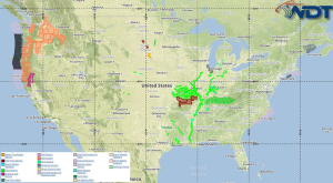
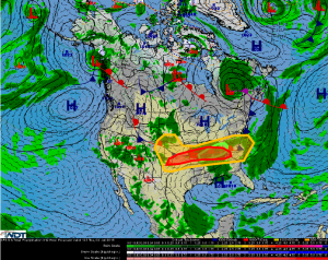
Severe thunderstorms are possible Thursday for the Central Plains and Southeast. Heavy rain and flooding is possible across the Mid South.
Central & Southeast: A nearly stationary frontal boundary stretching from the Mid-Atlantic
coast westward into the Central Plains will help provide a focus for a large area of strong to
severe thunderstorms today. Thunderstorms currently ongoing across the Mid-South will
likely re-intensify by midday or early afternoon due to increasing instability before
spreading eastward. Further west, an upper level disturbance moving southeastward across
the Great Plains and into the Mississippi River Valley will interact with the frontal boundary
and should allow for thunderstorm development across western portions of the Plains
during the afternoon hours, then spread east and southeast while increasing in coverage
during the late evening and overnight hours. Damaging winds will be the primary threat
across the entire region today, but some of the stronger storms could produce moderate to
large hail. Conditions will not be favorable for tornadoes, but a brief tornado cannot be
ruled out.
Mid-South: In addition to the potential for strong to severe thunderstorms, portions of the
Mid-South region, including much of Kentucky, Tennessee, and northeast Arkansas may
experience repeated rounds of thunderstorms throughout the day. Heavy rainfall will be
possible for much of this region, generally 1-3 inches.


