Hazardous Weather Outlook for Friday, April 4, 2014
by WeatherOps, on Apr 3, 2014 4:31:06 PM
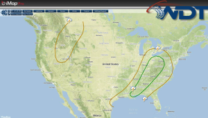
Severe thunderstorms will be possible tomorrow for portions of the Upper Ohio River Valley down to the Gulf Coast. Across the Upper Northeast, snow and light ice will be possible.
Although severe weather is possible on Friday, the threat is not as substantial as the past couple of days. A squall line from Thursday’s outbreak will be moving eastward, and severe parameters will be at their highest during the early parts of the day, so this is when any significant storms should occur, likely from Gulf Coast up through the Ohio River Valley. Damaging winds, hail, and possibly an embedded tornado will have an opportunity to form before losing their strength during the late afternoon/evening hours.
Meanwhile, as the low pressure system responsible for this activity moves into the central Great Lakes, moderate to heavy snow and some icing is expected for the region. Highest amounts from Minnesota and Iowa up through Wisconsin and Michigan look to be around 8-12 inches, with isolated higher totals. Wisconsin and Michigan could also see a tenth to a quarter of an inch of ice. Winds gusting around 30-40 mph will cause high drifts and blowing snow. The low will continue to lift northeast, which will spare the more eastern locations of the Great Lakes from seeing any significant winter weather activity.


