


by Mike Gauthier, on Nov 15, 2016 1:43:37 PM
My sister, from Minnesota, wrote me prior to her trip for the Colorado autumn leaf event, asking: “What is the weather like in Colorado in the fall, how should I pack?” Having experience in mountain weather, where the altitude change of a few thousand feet can be an entirely new phenomena of weather concerns, I advised her to prepare for everything from snow to 85 degrees, in other words… layers, lots of layers! I set up a location watch on my WDT WeatherOps App for a very long hike we were planning near Marble, Colorado.

The elevation of this hike starts about 7300 feet and ends around 8900 feet. All in all, this is not too extreme…for Colorado. The App also gives a nice hour by hour forecast for 48 hours and a 7 day outlook for temp and rain chances; perfect for planning an all day hike. (I’ll return to the day of the hike in a bit.) My sister would arrive a week early to enjoy some exploration and acclimation to altitude before the big hike, so we planned some driving tours and short hikes to prepare.
Day 1: Travel to the Grand Junction, CO airport over the Grand Mesa, elevation change from 6000’ (home) to 11000’ (top of Mesa), down to the airport at 4858’. My WDT WeatherOps app showed light rain and overcast in the 50’s at my house (6000 feet), higher up I knew that might be a concern. Then, timely, my App notified me that near my home location there was a snow advisory over 8000’. As we drove over the Mesa the temperature began to plummet and snow started falling around 8500’. By the time we hit the top it was a serious snow storm with several inches accumulating.

We traversed about 50 miles each way and experienced temperatures from 26 degrees to 70 degrees, sunshine to almost white-out conditions, all in a 3 hour time-frame. It was a fun day, showing off both Colorado weather and the WDT WeatherOps App, which provided situational awareness.
Day 2: The next day I wanted to get her acclimated so back we went to the top of the Grand Mesa at 10800’. Colorado’s Grand Mesa is one of the largest flat top mountains in the world and I knew the hiking would be high, but flat. My WDT WeatherOps app told me to expect temperatures in the 30’s up top. I have found that a pretty accurate rule of thumb, in the mountains, is that for every 1000 feet up in elevation you should plan on a 5 degree drop. We found a nice trail along a lake and walked in silence as the snow creaked and melted from the day before.
We paused for a picture along the trail getting drench when a pine bow let loose the snow is was holding.


Day 3: Having had enough of the snow, we decided to let the mountains thaw out and we headed to the desert to see Arches National Park (Moab, UT) and hike to the Delicate Arch. Using my App we determined it would be a nice sunny day and we could dress lighter this time. It was a perfect day and the hike, while very difficult, was well worth the trip.
This is really an awesome place well worth going, but be warned the hike to Delicate Arch was intense!

Day 4 and more: The next few days we took road-trips sprinkled with short hikes here and there. We took US 141, which is a national scenic byway, around the Uncompahgre National Forest landing in Telluride. Spent the day riding gondolas, walking through town and sipping micro-brews – we deserved a little break. We headed home over Dallas divide (which in my opinion is worth the whole trek). Due to the snow the previous weekend I knew the San Juan Mountains would be white and the leaves lower on the divide would be incredible. Weather was great and the app was dead on -- again.
The picture below does not do it justice, but this is Dallas Divide and Mt. Sneffels:

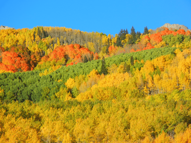
Day D -1: The final day of leaf pursuit. It is now the day prior to the big hike (D-Day) we are off to Crested Butte, deep in the heart of the Rockies. We intended to go via Kebler Pass and return home by the less treacherous route on Hwy 50. This pass is only open seasonally and is a dirt road. Though not very scary, as passes go, it is not maintained in winter. We were concerned about the weather since there had been snow and now there were ominous, low clouds; the WeatherOps App indicated we would be better off waiting until later in the afternoon to head over that pass. So, we reversed our plans and decided to check the App later that day while in town to see if we could head over Kebler on our way home. After lunching in Crested Butte, we determined (via the App) that we could indeed make the trek over Kebler Pass. We were not disappointed. Wow! If you want to see leaves, in the fall, in Colorado – you must put this one on your list. My sister said she got “QAF” (qwaf) quaking aspen fatigue from too much beauty. We barely made it down before dark because we had to stop and take pictures around every corner. This is a serious pass, so knowing the weather before you start off is not only smart - it’s required, in my opinion. Using the App we determined it was a GO! Mile after mile of the image below:
D-Day: Here we are back to the hike. We planned on hiking the Crystal River trail to the Crystal Mill. This is just outside of the little town of Marble, CO and one of the most photographed spots in Colorado. We had two days open as possibilities to be determined by the WDT WeatherOps App and chose Saturday. We left the truck at 8am, after a two hour drive to get there, it was 33 degrees out and the high temp was expected to be in the 70’s with a chance of afternoon rain. Heading out in blue skies and crisp temps we hiked 5 miles in to reach our destination and take in the majestic scenery.

After the long day of hiking we got back to the truck and headed into Marble for great BBQ and an adult beverage at the only place in town. As we sat around spinning yarns of our adventures, sure enough, at 2pm a light rain started just as the WDT WeatherOps App predicted.
This journey was an amazing time with family and absolute spectacular timing for the leaves. Something none of us will soon forget. We experienced snow, hail, sunshine, fog, rain, wind, intense heat, and cold all within 7 days – sometimes within the same day! I was prepared the whole time for any kind of weather and it made a huge difference in our situational awareness. A great weather app is a must for wilderness hiking, and even better is one with great accuracy. As they say… don’t leave home without it.
