National Weather Summary for Tuesday, July 28, 2015
by WeatherOps, on Jul 28, 2015 4:41:16 AM
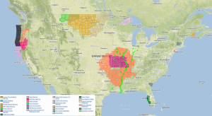
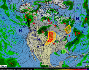
Strong to severe thunderstorms are possible Tuesday across the Upper Midwest and Central Plains. Strong thunderstorms are possible across the Northeast. Moderate to heavy rainfall is expected across Florida.
Upper Midwest to Central Plains: A strong low pressure system in Canada will continue moving east-northeastward today, bringing with it a cold front and warm front through the US. Showers and thunderstorms in association with these boundaries are ongoing this morning across parts of Minnesota and Iowa. This activity is not the focus for severe weather today, but rather fresh development along the cold front during the afternoon. Plentiful instability and shear should allow for some strong supercells to form at first with large hail, damaging wind gusts, and a low tornado threat possible before storms merge into clusters and a line. Moderately heavy rainfall will also be possible in the region, with 1-2 inches of rain possible, with locally higher amounts not out of the question.
Northeast: An upper level disturbance is forecast to move southward out of Quebec on Tuesday. By the afternoon hours, instability should be sufficient to allow for the development of thunderstorms. Strong thunderstorms containing gusty winds and small hail will be possible before weakening near or after sunset.
Florida:Weak low pressure near Florida will continue to produce showers and thunderstorms today. Areas of 1-2 inches of rainfall are not out of the question.


