National Weather Summary for Wednesday, July 15, 2015
by WeatherOps, on Jul 15, 2015 4:39:34 AM
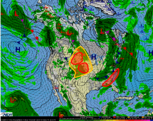
Scattered to numerous thunderstorms are possible Wednesday across the Northern and Central Plains. Scattered severe thunderstorms are possible for the coastal Carolinas and Southern Georgia.
Coastal Carolinas and Southern Georgia:Scattered strong to severe thunderstorms can be expected across this area during the afternoon and evening hours along and ahead of a slow moving cold front. The primary hazards will be hail and severe wind gusts.
Northern and Central Plains: Thunderstorms are ongoing this morning across portions of Kansas and Nebraska. The evolution of these storms will have a significant impact on how the late day severe weather threat evolves. Current indications are that an approaching disturbance will result in significant thunderstorm development across the area this afternoon and evening with an increasing severe weather threat as the day progresses.The primary threats will be severe winds and hail along with a low to moderate risk for tornadoes. Farther to the north scattered strong to severe thunderstorms capable of producing severe winds and hail will develop across eastern Montana into the western Dakotas during the late afternoon and evening hours ahead of an approaching cold front.


