National Weather Summary for Monday, June 22, 2015
by WeatherOps, on Jun 22, 2015 4:47:08 AM
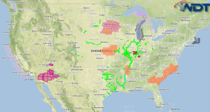
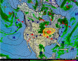
Scattered strong to severe thunderstorms are likely Monday across the Great Lakes. Strong to severe thunderstorms are likely across the Upper Midwest.
On Monday, a primary shortwave trough is forecast to move across Lake superior during the day, providing upper-level support for strong thunderstorm development. Steep mid-level lapse rates are forecast with rich moisture and strong buoyancy anticipated across the area. With daytime heating ahead of a cold front forecast to sweep through the region, a very unstable environment will be in place leading to severe thunderstorm development across the region. At this time, supercell thunderstorms are forecast to begin developing during the afternoon. With low-level shear across southern Wisconsin and northeastern Illinois, tornadoes will be possible with the potential for some tornadoes to be strong across the area. Damaging winds in excess of 70 mph and large hail in excess of 2.0 inches will be additional hazards possible within the developing thunderstorms along with frequent lightning and heavy rain.


