National Weather Summary for Wednesday, June 17, 2015
by WeatherOps, on Jun 17, 2015 5:10:03 AM
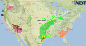
Heavy rainfall is possible Wednesday for portions of Eastern Texas and Oklahoma. Isolated severe thunderstorms are possible across the High Plains. Strong to severe thunderstorms are possible across the Ohio Valley.
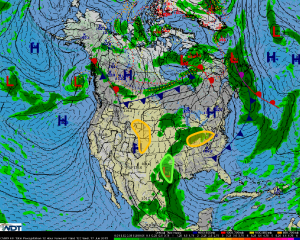
Eastern Texas and Oklahoma: The remnants of Tropical Depression Bill is forecast to interact with a trailing frontal boundary extended across central and northeastern Oklahoma on Wednesday, leading to heavy to excessive rainfall across the region. Total rainfall accumulation is forecast to range between 2 to 6 inches of rain with locally higher amounts possible, with flash flooding as the primary concern.
High Plains: Isolated strong to severe thunderstorm are forecast to develop during the afternoon across the northern High Plains on Wednesday. Weak southeasterly flow at the surface is forecast to maintain dewpoint values across the region providing moisture necessary for thunderstorm development into Wednesday. Daytime heating into the afternoon hours with moderate flow aloft will create a favorably unstable environment for severe thunderstorm development in the afternoon with storms progressing to the southeast into the evening and early overnight hours. Primary hazards associated with any developing thunderstorm include large hail, damaging winds, frequent lightning, and heavy rain.
Ohio Valley: Ongoing precipitation is forecast during the morning hours on Wednesday, with this area of precipitation potentially created outflow boundaries across the area. Into the afternoon hours, with daytime heating and moisture remaining across the region, moderate instability is forecast to interact with the aforementioned outflow boundaries as well as with a lifting warm front. As a result, clusters of showers and thunderstorms are forecast to develop with embedded thunderstorms having the potential to become severe. Primary hazards include damaging winds, hail, frequent lightning, and heavy rain.


