National Weather Summary for Monday, June 8, 2015
by WeatherOps, on Jun 8, 2015 4:55:12 AM
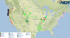
Particularly hazardous thunderstorms are possible Monday from the Ohio and Tennessee Valleys through the Delmarva Peninsula. Hazardous thunderstorms are possible from the South Central High Plains through the Ozarks. Heavy rainfall is possible across the Eastern US.
Ongoing thunderstorms across the Ohio and Tennessee Valleys through the Delmarva peninsula along a frontal boundary will continue through the day. These storms should reintensify during the day however uncertainty exists in regards to destabilization. Supercells are possible with clusters and line segments expected. Damaging winds will be the main concern, but large hail and tornadoes will be possible.
Upslope flow and a frontal boundary will fuel the potential for afternoon and evening thunderstorms for the Southern High Plains through the Ozarks. Large hail and damaging winds will be the primary threats.
Showers and thunderstorms moving across the Eastern US will allow for moderate to heavy rainfall across the eastern US. Localized flooding and flash flooding will be possible with rainfall amounts in excess of 2 inches.


