National Weather Summary for Wednesday, April 8, 2015
by WeatherOps, on Apr 8, 2015 9:50:26 AM
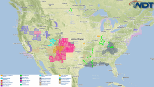
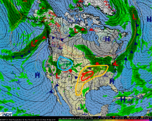
There will be an enhanced to moderate risk for severe thunderstorms Wednesday across the Southern and Central Plains, as well as the Missouri Valley. There is a conditional to slight risk for severe thunderstorms across the Midwest and Ohio Valley. Moderate snow is likely over the Northern Rockies.
Thunderstorms will likely develop across the Southern and Central Plains and the Missouri Valley today. Isolated strong thunderstorms will be near the Kansas and Oklahoma border. As thunderstorms develop, large hail, damaging winds, and tornadoes will be possible. Thunderstorms will continue into the evening further to the northeast with severe weather possible into the overnight hours.
A lingering frontal boundary across the Midwest and Ohio Valley will allow for thunderstorm development during the day with enough strength for strong to severe thunderstorms, The main threats will be hail and damaging winds, but an isolated tornado cannot be ruled out. Storms may persist overnight across the Ohio Valley.
An area of low pressure propagating eastward will allow showers and thunderstorms over Northern California will shift into the Northern Rockies with moderate to heavy snow expected. 4-8 inches of snow will be possible in the highest elevations with 2-4 inches more widespread.


