National Weather Summary for Friday, January 23, 2015
by WeatherOps, on Jan 23, 2015 9:44:30 AM
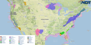
Showers and thunderstorms with heavy rainfall are likely Friday along the Gulf Coast and Southeast; flash flooding will be possible. Across the Southeast coast and into the Florida Panhandle, a few severe thunderstorms with damaging winds will be possible. Across the Tennessee Valley and into the Appalachians, rain, snow, and sleet will be possible; freezing rain is possible for the higher elevations.
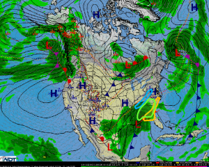
An area of low pressure will lift northeastward from the Gulf Coast into the Southeast and Mid Atlantic allowing for showers and thunderstorms with heavy rainfall. 2-3 inches of rain will be possible in addition to flash flooding.
A few severe thunderstorms will be possible across the Florida Panhandle into the Southeast Coastal areas with the main threats being damaging winds, small hail, and a few tornadoes.
Across the Tennessee Valley into the Appalachians, a rain/snow/sleet mix will be possible, becoming rain by afternoon. By evening, rain will transition back to snow. 1-2 inches of snow will be possible. Across the Appalachians, light freezing rain and sleet will be possible; accumulations will be under a tenth of an inch, but elevated surfaces may see up to a quarter of an inch; localized power outages will be possible. Moderate to heavy snow will occur across the mountains of western Virginia into southern Maryland where 2-5 inches of snow are expected.
A clipper system and cold front will bring some light snow to the Upper Great Lakes through Friday; only allowing for light amounts of snow. No major impacts are expected.


