Hazardous Weather Outlook for Saturday, January 17, 2015
by WeatherOps, on Jan 16, 2015 3:47:13 PM
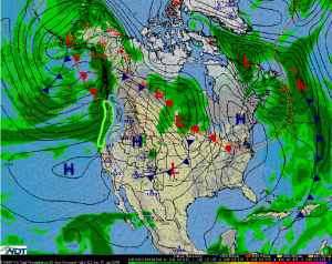
Moderate to heavy snow will continue across the Pacific Northwest on Saturday; some light icing will be possible. Heavy rain will be possible along the coastal areas along the Pacific Northwest.
Pacific Northwest: Another low pressure disturbance will approach the Pacific Coast late Friday evening and into Saturday morning. Precipitation is expected to develop across the coastal areas and spread eastward into the Coastal Range and Cascades on Saturday afternoon. Locally heavy rain west of the mountains and moderate to heavy snow will be possible through the ranges. Accumulations of 2-8 inches is expected, with heaviest accumulations up to 15 inches in areas of highest elevation. In addition, temperatures within valleys will likely hover at or slightly below freezing during the afternoon hours at the surface, keeping for a slight risk for icing. Accumulations at this time should remain generally under .25 of an inch.
As low pressure approaches from the west, heavy precipitation is expected to develop and spread eastward through the day on Saturday and into Sunday. Heavy rain, west of the mountains, with accumulations of 3-4 inches is anticipated. Locally heavier accumulations could occur.


