National Weather Summary for Friday, January 2, 2015
by WeatherOps, on Jan 2, 2015 10:00:41 AM
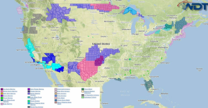
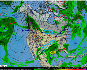
Another round of freezing rain and sleet is likely Friday for the Southern Plains and into Missouri. Snow showers will develop late in the day across the Upper Midwest. Isolated strong thunderstorms are possible for portions of Southeast Texas and Louisiana.
A band of precipitation stretching from Midland, Texas northeastward into Northwest Arkansas will lift northward through the morning with freezing rain and sleet likely through the morning. Areas from Midland to Wichita Falls will experience the longest duration of rain and sub freezing temperatures with ice accumulations to a quarter of an inch with locally higher amounts. A second round will develop late tonight as an area of low pressure over the Four Corners region begins to move eastward. Moderate to heavy snow will be possible for much of West Central Texas with 3-6 inches of snow possible. A second wave of sleet and freezing rain will be possible tonight across Northwest Texas into West Central Oklahoma and Missouri. A glaze to a tenth of an inch of ice will be possible through Saturday morning.
A series of disturbances along the Canadian border will allow for snow showers across North Dakota and Minnesota. Heavy snow with 4-6 inches will be possible tonight.
Showers and thunderstorms, with a few strong thunderstorms will be possible for Southeast Texas and Louisiana. Gusty winds to 45 mph will be possible.


