National Weather Summary for Tuesday, December 23, 2014
by WeatherOps, on Dec 23, 2014 9:52:09 AM
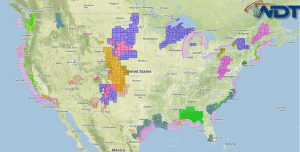
Strong to severe thunderstorms are possible Tuesday along the Gulf Coast; damaging winds and tornadoes will be possible in addition to heavy rain and flash flooding. Moderate to heavy snow will be possible for the Upper Mississippi Valley and Plains. Heavy snow will continue for the Cascades.
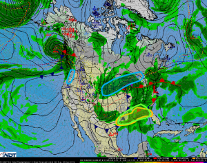
A cold front will approach the Gulf Coast today. As this occurs, an upper level disturbance will move through the region and moisture will be drawn northward ahead of the front. These features will allow widespread showers and thunderstorms. Some activity may be severe with lightning, gusty winds to 60 miles per hour, hail to 1.5 inches, and tornadoes. Heavy rain will be possible as well; 2-3 inches of rain will be common, but some areas could see in excess of 5 inches, allowing for flash flooding.
An intensifying area of low pressure and associated cold front will lift through the Upper Mississippi Valley and Northern Plains. Moderate to heavy snow will be possible from southern Minnesota into Wisconsin, and the Upper Peninsula of Michigan. 3-6 inches of snow will be possible in most areas, with lighter snow amounts of 1-3 inches will be possible across Nebraska and South Dakota.
An approaching frontal boundary from the Pacific will generate heavy snow for elevations above 8000 feet in the Cascades. 8-12 inches of snow will be possible.


