by WeatherOps, on Nov 13, 2014 9:48:05 AM

by WeatherOps, on Nov 13, 2014 9:48:05 AM
Moderate to heavy snow is likely Thursday for portions of the Coastal Range, Great Basin, and Rockies. Some icing is possible along and east of the Coastal Range.
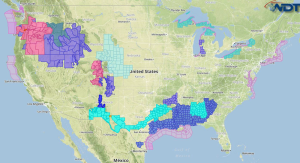
Current NWS Advisories/Watches/Warnings in iMapPro:

An area of low pressure will advance further inland across the Pacific Northwest and additional precipitation will spread eastward from the Great Basin into the Central Rockies. Moderate to heavy snow will be possible in the highest elevations with 3-6 inches possible, with locally higher amounts. Some icing will be possible through the Coastal Range in Northern Oregon and Southern Washington. Up to a quarter of an inch of ice is possible.
Lingering snow showers will continue through the Northern Great Lakes into Canada, but accumulations will remain under 6 inches. Across the Gulf of Mexico, thunderstorms will build through the day. Accumulations will remain below an inch with strong northerly winds.
This is where you give the visitor a brief introduction to both this blog and your company. Keep it short. More →