National Weather Summary for Monday, October 13, 2014
by WeatherOps, on Oct 13, 2014 9:55:33 AM
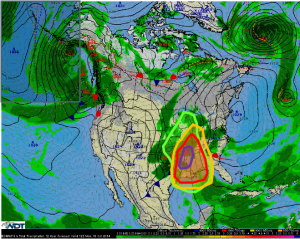
Severe thunderstorms with the potential for damaging winds and tornadoes will be possible today for portions of the Mid and Southern Mississippi Valley. Severe thunderstorms are likely from Illinois and Indiana to the Gulf Coast, as well as from Eastern Texas to the Alabama/Georgia border. Late night thunderstorm activity is possible from Southern Michigan through the Florida Panhandle. Heavy rain and flooding is possible from the Great Lakes to the Gulf of Mexico.
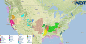
Current NWS Advisories/Watches/Warnings in iMapPro:

A line of thunderstorms ahead of a cold front will continue to move eastward into the Mississippi Valley and Gulf of Mexico, bringing strong to severe thunderstorms to a large portion of the country. As the low lifts into the Mid Mississippi Valley, it will increase thunderstorm coverage across the country.
A strong squall line moving through Texas, Arkansas, and Southern Missouri will continue to push eastward. With this activity, damaging winds over 70 miles per hour and embedded tornadoes will be the main concerns, with a lesser risk for hail.
The greatest risk for severe weather weather will be across portions of the Mid and Southern Mississippi Valley. Ongoing thunderstorms should intensify late this morning and into the early afternoon. Any cells ahead of the line will have the potential for large hail, damaging winds over 70 miles per hour, ad tornadoes.
From the Great Lakes to the Gulf of Mexico, thunderstorms and flooding will be possible. 1-2 inches of rain will be possible with 3-4 inches in portions of the Southern US. Isolated higher amounts and flash flooding are expected.


