by WeatherOps, on Oct 10, 2014 9:26:21 AM

by WeatherOps, on Oct 10, 2014 9:26:21 AM
Isolated strong thunderstorms are possible today for portions of the Arklatex into the Tennessee Valley. Heavy rain is possible from the Missouri/Arkansas border into West Central Texas.
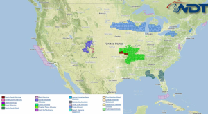
Current NWS Advisories/Watches/Warnings in iMapPro:

While significant severe weather is not expected, a cold front moving into Texas will pose a slight risk for thunderstorms capable of small hail and gusty winds to 45 miles per hour. Further east, the front will remain more stationary across the Arklatex into Tennessee. Scattered shower and thunderstorm activity will be possible through the day with isolated threats for small hail and winds. Ongoing activity from overnight will likely continue into the morning and afternoon. Rainfall to 2 inches and a risk for flooding and runoff possible.
This is where you give the visitor a brief introduction to both this blog and your company. Keep it short. More →