by WeatherOps, on Oct 6, 2014 9:44:56 AM

by WeatherOps, on Oct 6, 2014 9:44:56 AM
Strong to severe thunderstorms are possible today from the Lower Mississippi Valley to the Ohio Valley.
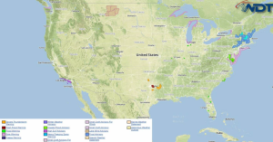
Current NWS Advisories/Watches/Warnings in iMapPro:

A large scale trough persists across the eastern US. The nose of the upper level jet will move into the Mid Mississippi Valley by late afternoon and move into the Ohio River Valley after dark. Instability in addition to moisture return will move northeastward into Kentucky along a lingering stationary boundary. Strong vertical shear and forcing will allow for the development of scattered strong to severe thunderstorms from Eastern Arkansas into Kentucky and to the border of Ohio and Pennsylvania.
The best chance for severe thunderstorms will be possible from Arkansas/Tennessee into Western Kentucky. Hail to 1.5", wind gusts to 55 mph, and a few tornadoes will be possible. While impacts may not be widespread, hail to 1" and winds to 45 miles per hour will be possible for portions of the Arklatex region into the Ohio Valley.
This is where you give the visitor a brief introduction to both this blog and your company. Keep it short. More →