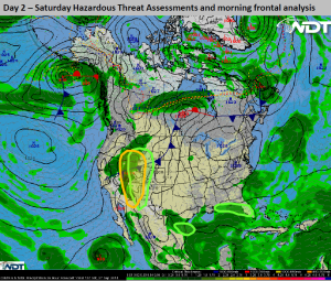
Hazardous Weather Outlook for Saturday, September 27, 2014
by WeatherOps, on Sep 26, 2014 3:52:06 PM
There is a slight risk for strong to isolated severe thunderstorms Saturday for the Four Corners region. Heavy rain will continue for the Great Basin. Heavy rain will be possible for the Northern High Plains associated with showers and general thunderstorms.
Great Basin & Desert Southwest: Broad upper low will expand into the Four Corners region on Saturday with thunderstorms, some severe, expected across the mountains. Isolated hail to 1.0 inch, winds gusting up 60 mph, and a few tornadoes will be the primary threat with the stronger storms.
Intermoutain West & Four Corners:
Slow moving upper-level low pressure system and associated cold front will maintain showers and thunderstorms across the region on Saturday. Heavy rainfall with the stronger storms may pose a risk for flash flooding in some areas.
Extreme South Texas: Showers and thunderstorms may linger across south-central Texas through the morning hours on Saturday as low pressure dissipates further inland. An already saturated surface will pose a slight risk for minor flooding and local runoff.
Southeast Gulf Coast: A stalled frontal boundary will remain just offshore, and a weak area of low pressure is likely to form along this front and track northward. While the heaviest rainfall threat is expected to remain over the waters of the northern Gulf of Mexico, some flash flooding will be possible along the immediate coastal areas.


