National Weather Summary for Tuesday, February 4, 2014
by WeatherOps, on Feb 4, 2014 9:29:09 AM
Snow, sleet, and freezing rain will move across portions of the Plains through the remainder of the morning and snow will expand into portions of Nebraska, Iowa, and Missouri this afternoon. Later tonight, snow will move into portions of the Midwest and Ohio River Valley. Scattered thunderstorms will move into the Lower Mississippi River Valley tonight.
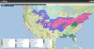
Current NWS Advisories/Watches/Warnings from iMapPro:

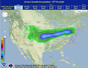
With the jet stream over the Central Plains, active weather will continue for the next three days. Some of the precipitation has come to an end over portions of Oklahoma due to drier air working into the region. Some additional snow is possible through the morning, but should come to an end across Oklahoma by the afternoon. Later tonight, snow will expand into the Midwest and Northeast where 2-5 inches of snow will be possible. The heaviest of the snow will be across portions of Oklahoma, Kansas, and Missouri where 5-10 inches, with locally higher amounts will be possible.
Sleet and freezing rain are continuing across portions of Arkansas. Up to a tenth of an inch of ice is possible on elevated surfaces, but ice accumulations are not expected to exceed a quarter of an inch. The potential for freezing rain will lift to the northeast throughout the day with ice accumulations possible from the Missouri Bootheel, along the Ohio River, and into Pennsylvania, West Virginia, and Maryland.
Thunderstorms will also continue into the Lower Mississippi Valley this afternoon, but no significant impacts are expected.
WDT preferred forecast for 24 hour snow accumulation through 6AM CST Wednesday


