


by David Moran, on Aug 7, 2018 11:19:43 AM
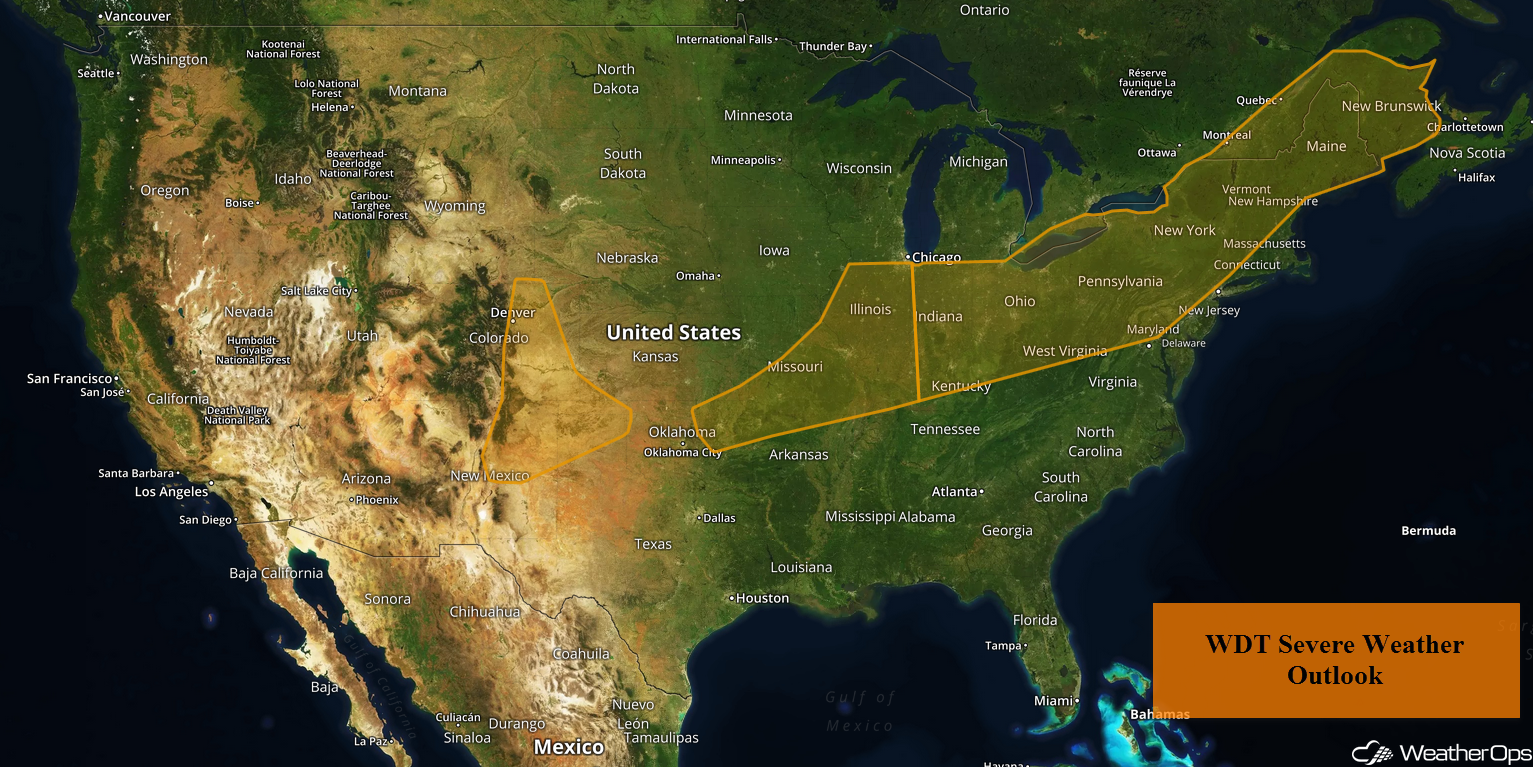
A cold front will be the focus for thunderstorm development from the Central US into the Northeast on Tuesday. Thunderstorms may develop across the High Plains along a stalled front. Some of this activity will pose a risk for excessive rainfall. As a slow moving cold front moves southward, there will be a potential for excessive rainfall from the Southern Plains into the Ozarks.
- Thunderstorms from the Central US into the Northeast on Tuesday
- Risk for Thunderstorms Tuesday across the High Plains
- Excessive Rainfall for the High Plains on Tuesday
- Potential for Excessive Rainfall Tuesday from the Southern Plains into the Ozarks
- Thunderstorm Potential for the Mid Atlantic and Central Appalachians on Wednesday
- Excessive Rainfall Wednesday for the Central Appalachians
- Thunderstorms for the High Plains Wednesday
- Risk for Excessive Rainfall Wednesday and Thursday across the Southwest
- Potential for Excessive Rainfall from the Southern Plains into the Lower Mississippi Valley Wednesday into Thursday
- Tropical Update
US Hazards
Thunderstorms from the Central US into the Northeast on Tuesday
A few clusters of showers and embedded thunderstorms are ongoing across the Central US along a slow moving cold front. Additional activity may develop during the afternoon and early evening. Damaging winds and hail will be the primary hazards with these storms.
Major Cities in Region: Des Moines, IA, Chicago, IL, Indianapolis, IN, Detroit, MI, Pittsburgh, PA, Buffalo, NY, Burlington, VT, Augusta, ME
Thunderstorm Risk for Tuesday
Risk for Thunderstorms Tuesday across the High Plains
A stalled front along the lee side of the Rockies will allow for the development of widely scattered showers and thunderstorms in the higher terrain by mid to late afternoon. Strong to severe thunderstorms will intensify as they move out of the higher terrain southeastward across southeast Colorado and the High Plains. Large hail and damaging winds will be the primary hazards, but an isolated tornado or two cannot be ruled out.
Major Cities in Region: Albuquerque, NM, Denver, CO, Colorado Springs, CO, Goodland, KS, Guymon, OK, Dodge City, KS
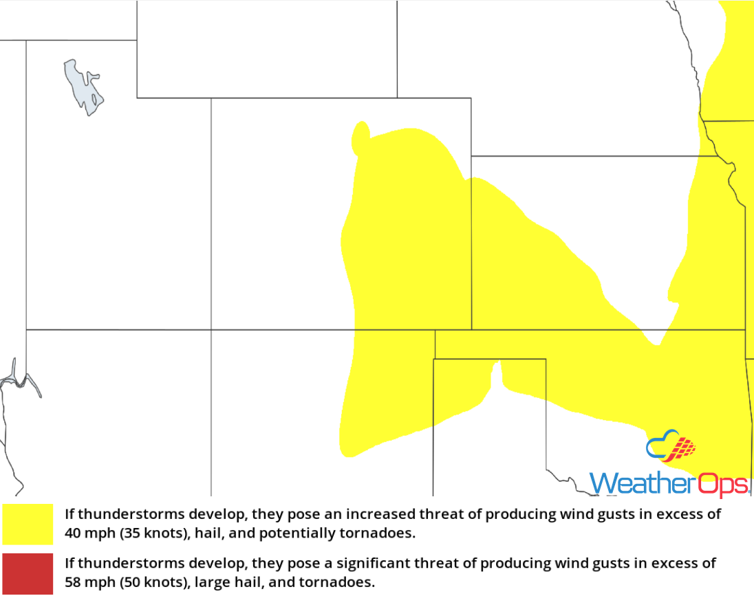
Thunderstorm Risk for Tuesday
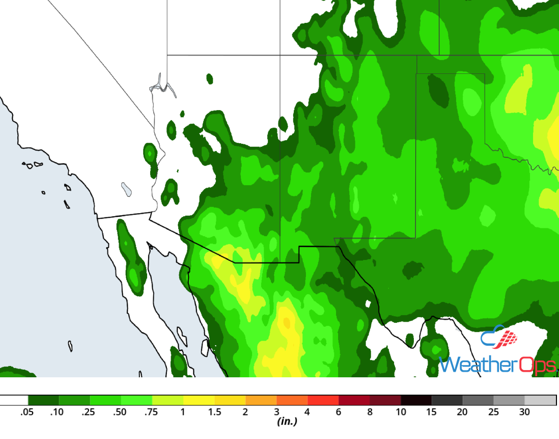
Excessive Rainfall for the High Plains on Tuesday
In addition to the thunderstorms described above, there will be a risk for heavy to excessive rainfall. Rainfall totals of 1-3 inches are forecast, contributing to a risk for localized flash flooding.
Major Cities in Region: Colorado Springs, CO, Pueblo, CO
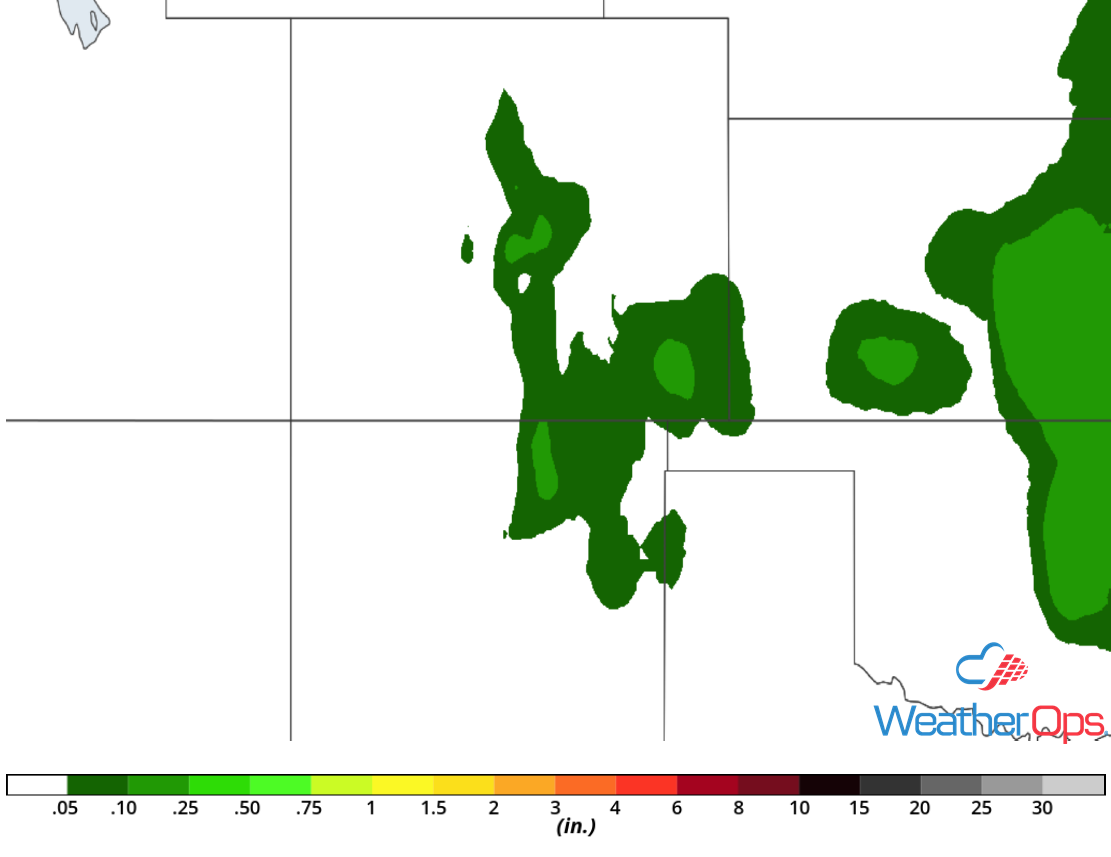
Rainfall Accumulation for Tuesday
Potential for Excessive Rainfall Tuesday from the Southern Plains into the Ozarks
Multiple clusters of thunderstorms are likely to move east-southeastward ahead of a slow moving cold front on Tuesday. High moisture content will allow thunderstorms that develop to produce rainfall rates in excess of 1-2 inches per hour. Given that some areas may receive multiple rounds of thunderstorms, rainfall totals may exceed 3 inches. This will contribute to a risk for isolated flash flooding.
Major Cities in Region: Tulsa, OK, Joplin, MO, Springfield, MO
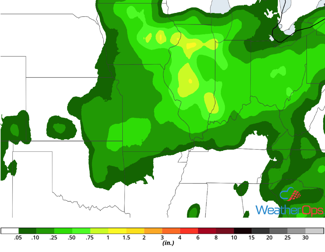
Rainfall Accumulation for Tuesday
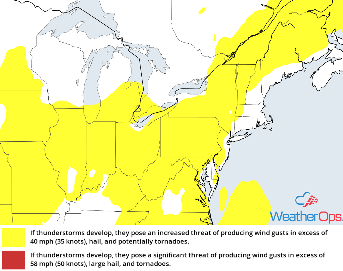
Thunderstorm Potential for the Mid Atlantic and Central Appalachians on Wednesday
Isolated showers and cloud cover associated with a slowing cold front will impact the region Wednesday morning. By the afternoon, an upper level trough will promote strengthening winds within the mid-levels of the atmosphere. Daytime heating and these increased winds will support the development of widely scattered storms along with a few strong storms capable of producing damaging winds.
Major Cities in Region: Charleston, WV, Pittsburgh, PA, Richmond, VA, Washington, DC, Philadelphia, PA, New York, NY
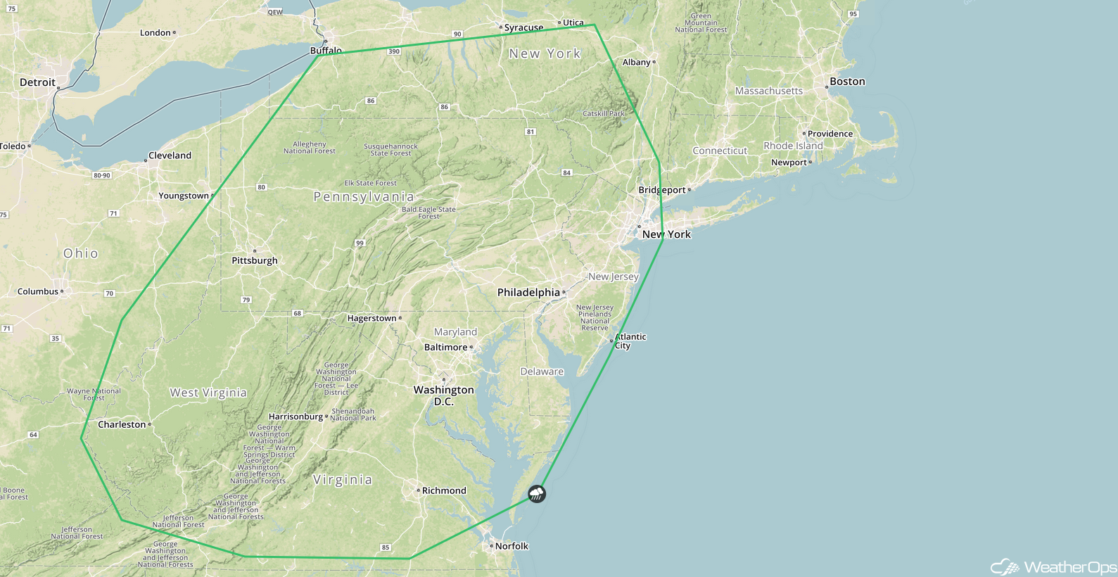
SPC Convective Outlook for Wednesday
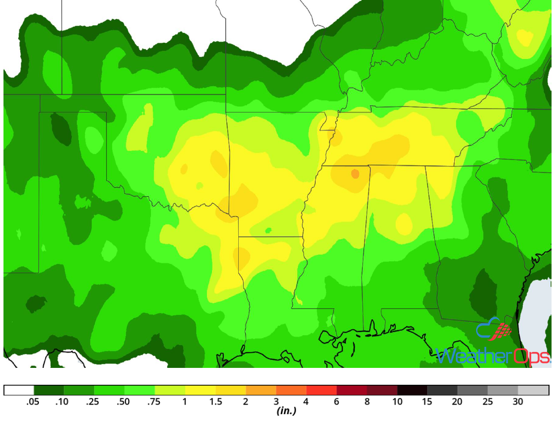
Excessive Rainfall Wednesday for the Central Appalachians
In addition to the severe weather potential described above, there will be a risk for excessive rainfall. Rainfall totals of 1-2 inches with locally higher amounts in excess of 3 inches are expected.
Major Cities in Region: Columbus, OH, Charleston, WV
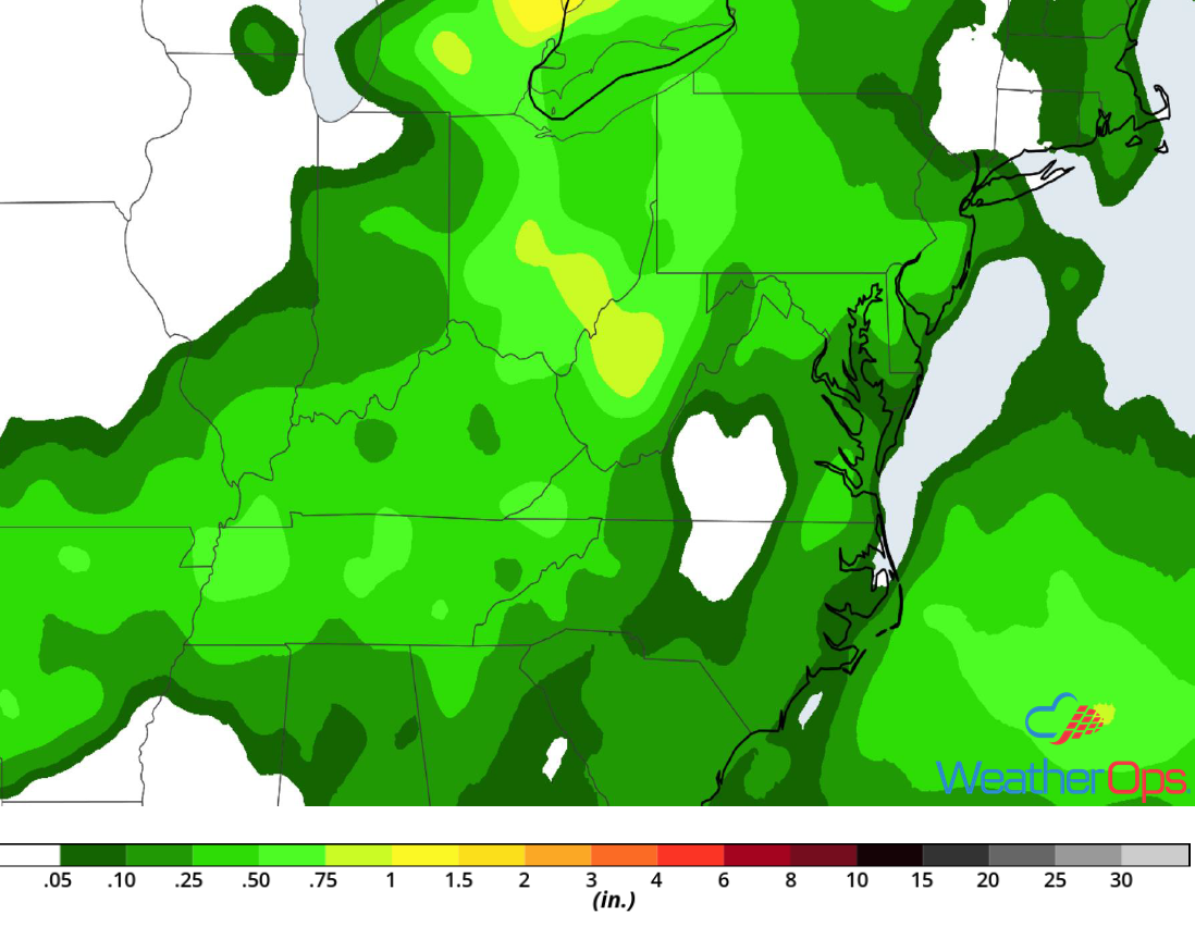
Rainfall Accumulation for Wednesday
Thunderstorms for the High Plains Wednesday
A few thunderstorm clusters may be ongoing across the area late Tuesday night into early Wednesday. While there may be one or two strong storms, a greater potential will exist Wednesday afternoon and evening. An upper level low will move into the region during the afternoon. With instability and strong wind shear in place, damaging winds and large hail will be the primary hazards with the stronger storms that develop.
Major Cities in Region: Santa Fe, NM, Colorado Springs, CO, Amarillo, TX, Guymon, OK
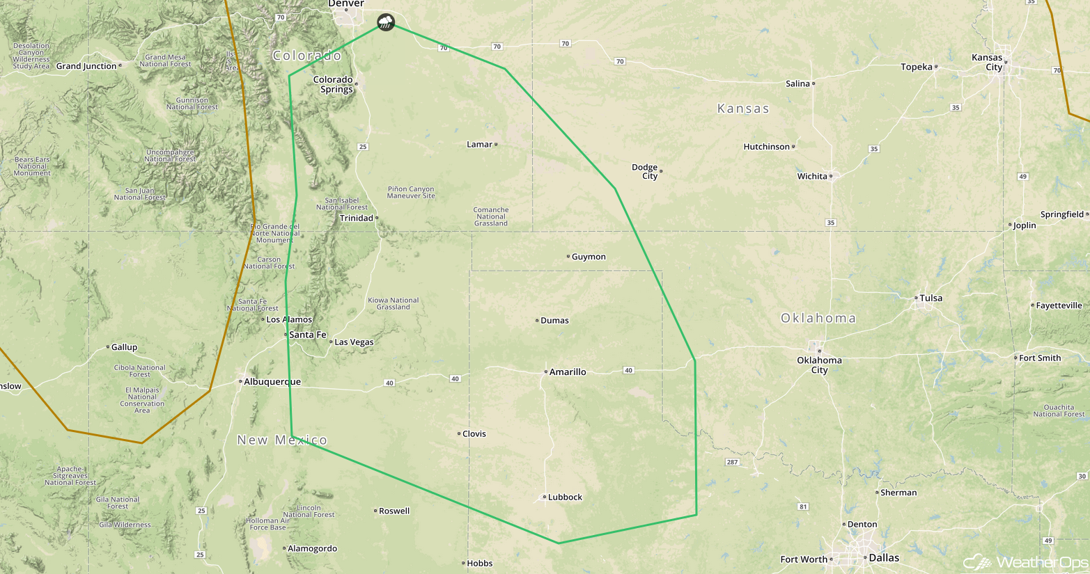
SPC Convective Outlook for Wednesday
Risk for Excessive Rainfall Wednesday and Thursday across the Southwest
A slow-moving cold front along the lee side of the Rockies and an active monsoon pattern will promote the development of thunderstorms from southeast Colorado southwestward across much of New Mexico and Arizona. Storms further east will move southward whereas storms further west will move westward. Two day rainfall totals may exceed an inch, resulting in a risk for flash flooding.
Major Cities in Region: Phoenix, AZ, Tucson, AZ, Truth or Consequences, NM, Roswell, NM
Rainfall Accumulation through Thursday
Potential for Excessive Rainfall from the Southern Plains into the Lower Mississippi Valley Wednesday into Thursday
A cold front will stall from north Texas and Oklahoma eastward into the Mississippi and Tennessee Valleys on Wednesday, This front will promote scattered thunderstorm development Wednesday into Thursday. Given the plentiful moisture along and to the south of the front, heavy rainfall is likely. Two day rainfall totals of 1-2 inches with locally higher amounts in excess of 3 inches are forecast.
Major Cities in Region: Dallas, TX, Texarkana, AR, Memphis, TN, Nashville, TN
Rainfall Accumulation through Thursday
Tropical Update
Subtropical Storm Debby has developed and is 1160 miles west of the Azores. Debby is moving northward 16 mph. This general motion is expected to continue over the next 24 hours with a decrease in forward speed. The forecast is to turn toward the northeast thereafter. Maximum sustained winds are at 40 mph with higher gusts. Debby is forecast to dissipate within a few days.
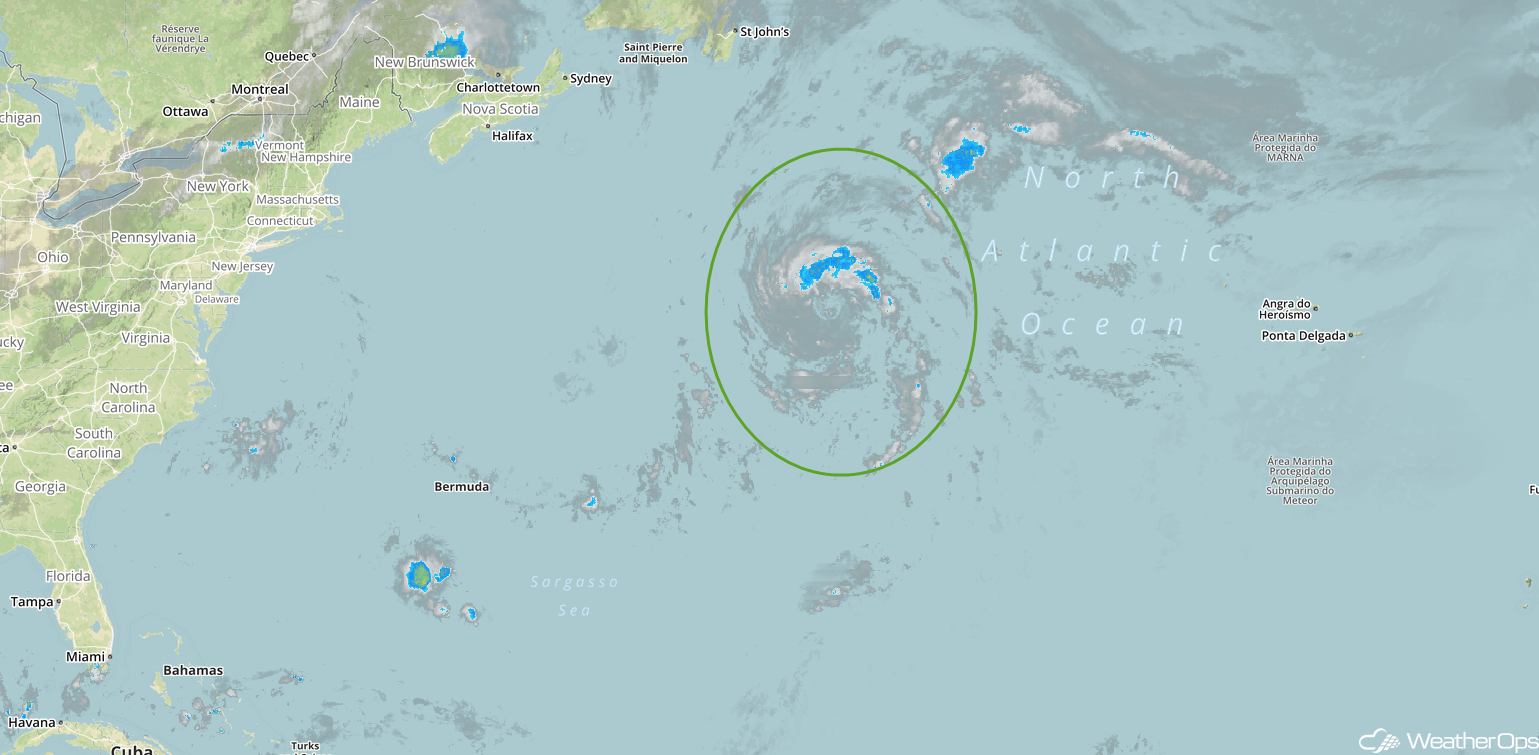
Enhanced Infrared Satellite
A Look Ahead
Showers and thunderstorms will continue from east Texas into the Southeast on Friday along and ahead of the cold front described above. Some lighter activity may persist into Saturday. By Sunday, showers and thunderstorms will move into the Ohio Valley and Mid Atlantic. Heavy rain may develop across western portions of Texas and Oklahoma on Monday.
